File:Holy Alliance.png
跳转到导航
跳转到搜索
没有更高的分辨率。
Holy_Alliance.png (262 × 197像素,文件大小:4 KB,MIME类型:image/png)
说明
说明
添加一行文字以描述该文件所表现的内容
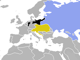
Map of Holy Alliance of 1815

|
File:Map of the Holy Alliance (1840).svg是此文件的矢量版本。 如果此文件质量不低于原点阵图,就应该将这个PNG格式文件替换为此文件。
File:Holy Alliance.png → File:Map of the Holy Alliance (1840).svg
更多信息请参阅Help:SVG/zh。 |
.svg) |
| 描述 | Map of Europe, highlighting the Holy Alliance of 1815 | ||
| 日期 | (UTC) | ||
| 来源 | Cropped and colourised from Image:BlankMap-World-1840.png | ||
| 作者 | OwenBlacker | ||
| 授权 (二次使用本文件) |
|
文件历史
点击某个日期/时间查看对应时刻的文件。
| 日期/时间 | 缩略图 | 大小 | 用户 | 备注 | |
|---|---|---|---|---|---|
| 当前 | 2009年8月2日 (日) 15:01 | | 262 × 197(4 KB) | Berillium(留言 | 贡献) | Reverted to version as of 14:59, 17 November 2007 merges |
| 2009年8月2日 (日) 01:04 |  | 262 × 197(6 KB) | Buonaparte69~commonswiki(留言 | 贡献) | Russia change to traditional 19th-century colour of green. | |
| 2007年11月17日 (六) 14:59 |  | 262 × 197(4 KB) | OwenBlacker(留言 | 贡献) | Correction: I'd forgotten to colourise the Rhenish exclave of Prussia | |
| 2007年10月18日 (四) 21:19 |  | 262 × 197(4 KB) | OwenBlacker(留言 | 贡献) | {{Information |Description=Map of Europe, highlighting the Holy Alliance of 1815 |Source=Cropped and colourised from Image:BlankMap-World-1840.png |Date=~~~~~ |Author=~~~ |other_versions= |Licencing={{PD-user-w|en|Engli |
您不可以覆盖此文件。
文件用途
以下页面使用本文件:
全域文件用途
以下其他wiki使用此文件:
- en.wikipedia.org上的用途