File:Hopi reservation partion & Navajo Reservation.JPG
Aller à la navigation
Aller à la recherche

Taille de cet aperçu : 729 × 600 pixels. Autres résolutions : 292 × 240 pixels | 584 × 480 pixels | 934 × 768 pixels | 1 245 × 1 024 pixels | 1 900 × 1 563 pixels.
Fichier d’origine (1 900 × 1 563 pixels, taille du fichier : 376 kio, type MIME : image/jpeg)
Légendes
Légendes
Ajoutez en une ligne la description de ce que représente ce fichier
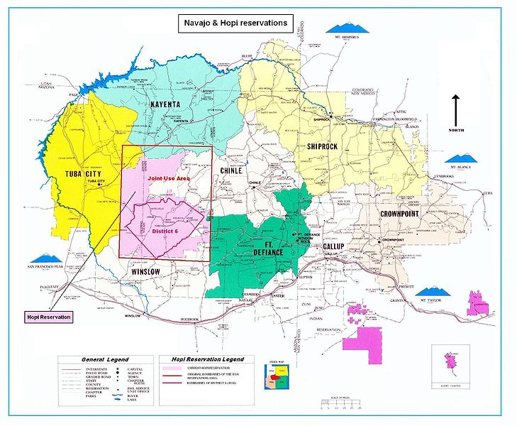
Map of the Hopi reservation in Navajo Nation, showing 1882 boundaries, 1936 District 6, and the 1962 Joint Use Area.
| Description |
Map of the Hopi reservation in Navajo Nation. The map shows in particular:
|
|||||||||
| Date | (UTC) | |||||||||
| Source | ||||||||||
| Créé par |
|
|||||||||
| Données géotemporelles | ||||||||||
| Rectangle englobant |
|
|||||||||
| Géoréférencement | ||||||||||

|
Cette image (de type carte) devrait être recréée dans un format vectoriel, en tant que fichier SVG. Cela offrirait plusieurs avantages : voir Commons:Media for cleanup pour plus d'informations. Si une version SVG de cette image est déjà disponible, merci de bien vouloir l'envoyer. Après cela, remplacez ce modèle par {{vector version available|nouveau nom d'image.svg}}.
|


| Cette image a été retouchée, ce qui signifie qu'elle a été modifiée par ordinateur et est différente de l'image d'origine. Liste des modifications : Boundaries of Hopi reservation end his partition. L'image d'origine se trouve ici : Navajo-Nation-Map-PHS.jpg:
|
| This image is in the public domain in the United States because it contains materials that originally came from the U.S. Public Health Service, taken or made as part of an employee's official duties. As works of the U.S. federal government, all Public Health Service images are in the public domain in the United States. | .svg) |
Journal des téléversements d’origine[modifier]
This image is a derivative work of the following images:
- File:Navajo-Nation-Map-PHS.jpg licensed with PD-USGov
- 2007-07-14T19:22:34Z Bejnar 1900x1563 (1576169 Bytes) {{Information |Description=Map of the Navajo Nation |Source=[http://www.ihs.gov/FacilitiesServices/AreaOffices/Navajo/naihs-nation-map.asp "Navajo Nation Map" Navajo Area Indian Health Service, Public Health Service] |Date=2
Téléversé avec derivativeFX
Historique du fichier
Cliquer sur une date et heure pour voir le fichier tel qu'il était à ce moment-là.
| Date et heure | Vignette | Dimensions | Utilisateur | Commentaire | |
|---|---|---|---|---|---|
| actuel | 12 avril 2010 à 19:41 | | 1 900 × 1 563 (376 kio) | Mario1952 (d | contributions) | Color of image border Category:Maps of Native American tribal territories |
| 5 avril 2010 à 15:19 |  | 1 900 × 1 563 (393 kio) | Mario1952 (d | contributions) | {{Information |Description=Map of the Navajo Nation |Source=*File:Navajo-Nation-Map-PHS.jpg |Date=2010-04-05 15:18 (UTC) |Author=*File:Navajo-Nation-Map-PHS.jpg: compiled by Aces Products under contract for the Indian Health Service, US Public |
Vous ne pouvez pas remplacer ce fichier.
Utilisations locales du fichier
Aucune page n’utilise ce fichier.
Utilisations du fichier sur d’autres wikis
Les autres wikis suivants utilisent ce fichier :
- Utilisation sur ca.wikipedia.org
- Utilisation sur en.wikipedia.org
- Utilisation sur fr.wikipedia.org
- Utilisation sur it.wikipedia.org
- Utilisation sur oc.wikipedia.org