File:Houston Ship Channel Barbours Cut.jpg
跳转到导航
跳转到搜索

本预览的尺寸:800 × 534像素。 其他分辨率:320 × 214像素 | 640 × 427像素 | 1,024 × 683像素 | 1,500 × 1,001像素。
原始文件 (1,500 × 1,001像素,文件大小:693 KB,MIME类型:image/jpeg)
说明
说明
添加一行文字以描述该文件所表现的内容
| 描述 |
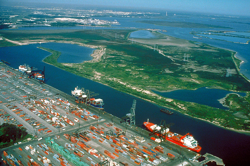
English: Aerial view of the Barbour's Cut area on the Houston Ship Channel in Houston, Texas, USA. This area is a large container terminal. This photograph appears to have been taken before the Fred Hartman Bridge was built, or when the bridge was under construction. In a present-day photograph, the bridge should be clearly visible at top right.
Coordinates: 29°40′54.98″N 94°59′54.37″W / 29.6819389°N 94.9984361°W |
|||
| 图中地点 | Houston, Texas, USA | |||
| 日期 | Probably pre-1995 | |||
| 来源 |
U.S. Army Corps of Engineers Digital Visual Library Image page Image description page Digital Visual Library home page |
|||
| 作者 | U.S. Army Corps of Engineers, photographer not specified or unknown | |||
| 授权 (二次使用本文件) |
|
文件历史
点击某个日期/时间查看对应时刻的文件。
| 日期/时间 | 缩略图 | 大小 | 用户 | 备注 | |
|---|---|---|---|---|---|
| 当前 | 2007年5月10日 (四) 01:22 | | 1,500 × 1,001(693 KB) | DanMS(留言 | 贡献) | {{Information | Description = {{en|Aerial view of the Barbour's Cut area on the Houston Ship Channel in Houston, Texas, USA. This area is a large container terminal. This photograph appears to have been taken before the Fred Hartman Bridge was built, o |
您不可以覆盖此文件。
文件用途
全域文件用途
以下其他wiki使用此文件:
- ar.wikipedia.org上的用途
- bn.wikipedia.org上的用途
- de.wikipedia.org上的用途
- en.wikipedia.org上的用途
- es.wikipedia.org上的用途
- eu.wikipedia.org上的用途
- fi.wikipedia.org上的用途
- fr.wikipedia.org上的用途
- gu.wikipedia.org上的用途
- hu.wikipedia.org上的用途
- it.wikipedia.org上的用途
- ja.wikipedia.org上的用途
- lt.wikipedia.org上的用途
- ml.wikipedia.org上的用途
- nl.wikipedia.org上的用途
- no.wikipedia.org上的用途
- pl.wikipedia.org上的用途
- pnb.wikipedia.org上的用途
- pt.wikipedia.org上的用途
- ru.wikipedia.org上的用途
- te.wikipedia.org上的用途
- tr.wikipedia.org上的用途
- uk.wikipedia.org上的用途
- ur.wikipedia.org上的用途
- uz.wikipedia.org上的用途
- vi.wikipedia.org上的用途
- www.wikidata.org上的用途
查看此文件的更多全域用途。