File:Huaraz, Perú.jpg
Jump to navigation
Jump to search

Size of this preview: 600 × 600 pixels. Other resolutions: 240 × 240 pixels | 480 × 480 pixels | 768 × 768 pixels | 1,024 × 1,024 pixels | 2,292 × 2,292 pixels.
Original file (2,292 × 2,292 pixels, file size: 2.57 MB, MIME type: image/jpeg)
Captions
Captions
Add a one-line explanation of what this file represents
Summary
[edit]
| Description |
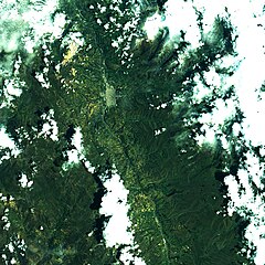
Português: Huaraz, Perú, sábado passado. Uma das maiores cidades dos Andes Peruanos, a 3.000m de altitude, sua área urbana aparece em salpicado no centro da imagem. Está às margens do Rio Santa que cruza a imagem de S a N. Em verde claro agricultura, em verde escuro páramo. Neve em branco, nuvens também, e suas sombras em preto. No alto à dir., em azul, a Laguna Malaca, a 4.600m no Parque Nacional Huascarán. No alto à esq., em amarelo, mineração de ouro a céu aberto na Mina Pierina, entre 3.800 e 4.200m / Huaraz, Peru, last saturday. One of Peru´s Andes largest towns, it is almost at 10,000 ft. Its urban area appears in saltpepper at image center, beside Santa River, crossing image from S to N. Agriculture in light green. Páramo, alpine tundra, in dark green. Snow in white, as well as clouds, and its shadows in black. At image right top, in blue, Malaca Lake, at 15,000 ft on Huascarán National Park. At image left top, in yellow, Pierina Mine, open pit gold mining between 12,000 and 14,000 ft.
Imagem / Image CBERS4 MUX Huaraz, Perú. Coordenadas do centro da imagem / Image center: 9°31'41.3"S 77°31'55.7"W Data / Date: 04-01-2020 / 2020-04-01 RGB765 Cena / Scene: 190 / 111 Autor / Author: Oton Barros (DSR/OBT/INPE) Imagem em HD / HD Image Visite-nos em www.dsr.inpe.br |
| Date | |
| Source | https://www.flickr.com/photos/153282474@N02/49345028441/ |
| Author | Coordenação-Geral de Observação da Terra/INPE |
Licensing
[edit]
This file is licensed under the Creative Commons Attribution-Share Alike 2.0 Generic license.
- You are free:
- to share – to copy, distribute and transmit the work
- to remix – to adapt the work
- Under the following conditions:
- attribution – You must give appropriate credit, provide a link to the license, and indicate if changes were made. You may do so in any reasonable manner, but not in any way that suggests the licensor endorses you or your use.
- share alike – If you remix, transform, or build upon the material, you must distribute your contributions under the same or compatible license as the original.
| This image was originally posted to Flickr by Coordenação-Geral de Observação da Terra/INPE at https://flickr.com/photos/153282474@N02/49345028441. It was reviewed on 9 April 2020 by FlickreviewR 2 and was confirmed to be licensed under the terms of the cc-by-sa-2.0. |
File history
Click on a date/time to view the file as it appeared at that time.
| Date/Time | Thumbnail | Dimensions | User | Comment | |
|---|---|---|---|---|---|
| current | 10:12, 9 April 2020 | | 2,292 × 2,292 (2.57 MB) | Jo-Jo Eumerus (talk | contribs) | Uploaded a work by Coordenação-Geral de Observação da Terra/INPE from https://www.flickr.com/photos/153282474@N02/49345028441/ with UploadWizard |
You cannot overwrite this file.
File usage on Commons
The following page uses this file:
- File:Huaraz, Perú (49345028441).jpg (file redirect)
.jpg&redirect=no)