File:Hulun Lake NASA.jpg
Jump to navigation
Jump to search

Size of this preview: 800 × 571 pixels. Other resolutions: 320 × 228 pixels | 640 × 457 pixels | 1,034 × 738 pixels.
Original file (1,034 × 738 pixels, file size: 184 KB, MIME type: image/jpeg)
Captions
Captions
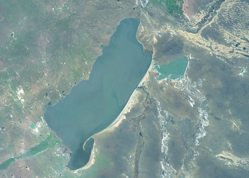
Hulun Lake (Dalai Nor) on northeast China, near the borders of Russia and Mongolia. Basin of the Amur River
Summary[edit]
| Description |
Русский: Также Хулуньчи, Хулуньху или Хулун-Нур, одно из крупнейших озёр Китая. С юго-западной стороны в озеро впадает река Керулен, с востока — Орчун-Гол. С севера тонкой ниткой видна Мутная протока, которая связывает озеро с рекой Аргунь: при высоком уровне в реке Аргунь вода по Мутной протоке поступает в озеро. Если уровень в озере выше, то течёт в обратном направлении. Часть вод Аргуни сбрасывается в озеро по специальному каналу (не виден). Аргунь извивается к северу от озера.
中文:阿穆爾河流域
English: One of the largest lakes of China. In the southwest, the flowing River Crulen is visible, in the east - the River Orchen. In the north, a narrow natural channel Xinkai River (used to be Dalaneluoumu) connects the lake with the Argun River (tributary of the Amur). A new canal has also been built, but it is not visible |
| Date | Unknown date |
| Source | Screenshot from NASA World Wind software, Blue Marble & Landsat layer |
| Author | NASA |
| Object location | | View this and other nearby images on: OpenStreetMap |
|---|
Licensing[edit]
| This image is in the public domain because it is a screenshot from NASA’s globe software World Wind using a public domain layer, such as Blue Marble, MODIS, Landsat, SRTM, USGS or GLOBE.
|
 |
File history
Click on a date/time to view the file as it appeared at that time.
| Date/Time | Thumbnail | Dimensions | User | Comment | |
|---|---|---|---|---|---|
| current | 15:30, 15 February 2022 | | 1,034 × 738 (184 KB) | Proeksad (talk | contribs) | Uploaded a work by NASA from Screenshot from NASA World Wind software, Blue Marble & Landsat layer with UploadWizard |
You cannot overwrite this file.
File usage on Commons
There are no pages that use this file.
File usage on other wikis
The following other wikis use this file:
- Usage on ru.wikipedia.org