File:Huntington Library collection Rancho Sausal Redondo US survey plat map.jpg

Original file (6,202 × 5,285 pixels, file size: 5.1 MB, MIME type: image/jpeg)
Captions
Captions
Summary[edit]
| Description |
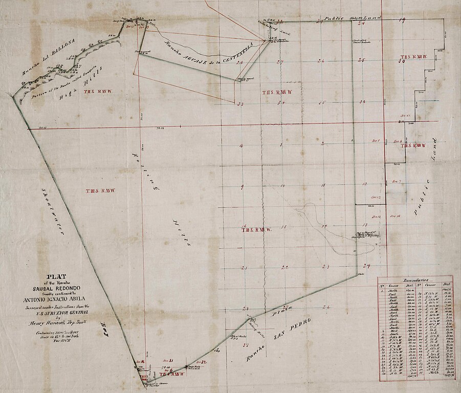
English: Huntington Library collection Rancho Sausal Redondo US survey plat map |
| Date | |
| Source |
Title Plat of the Rancho Sausal Redondo. Creator Hancock, Henry, 1822-1883, surveyor. Date Searchable 1855; 1856; 1857; 1858; 1859; 1860; 1861; 1862; 1863; 1864; 1865 Date undated Call Number SR_Map_0258 Physical Description 1 ms. map ; 18 x 22 in., on sheet 24 x 23 1/4 in., ink on tracing cloth Scale 1 : 40 chains Location depicted Sausal, Rancho Redondo Beach El Segundo Inglewood Description Bordered by ranchos San Pedro, La Ballona, Aguaje de la Centinela; Shoalwater Bay & Public lands. Finally confirmed to Antonio Ignacio Abila Containing 31,600 46/100 Acres. Numbered sections with bearings, distances, color highlighting, minor topographical details: portion of the Rancho called Guaspita. Inset with table of boundary data. Subjects Avila, Antonio. California -- History -- 1850-1950. El Segundo (Calif.) historical maps. (aat) Inglewood (Calif.) Los Angeles County (Calif.) -- Maps. Ranches -- California, Southern -- Maps. Real property -- Maps. Redondo Beach (Calif.) Surveying -- California, Southern -- History. Physical Collection Solano-Reeve collection Rights For information on use of Digital Library materials, please see Library Rights and Permissions: https://www.huntington.org/library-rights-permissions Digital Collection Maps, Huntington Digital Library Digitization Specifications High Res Unique Digital Identifier 313126 IIIF Manifest https://hdl.huntington.org/iiif/info/p15150coll4/11649/manifest.json IIIF Image https://hdl.huntington.org/digital/iiif/p15150coll4/11649/full/full/0/default.jpg |
| Author | Henry Hancock |
Licensing[edit]
This work is in the public domain in the United States because it was published (or registered with the U.S. Copyright Office) before January 1, 1929.
Public domain works must be out of copyright in both the United States and in the source country of the work in order to be hosted on the Commons. If the work is not a U.S. work, the file must have an additional copyright tag indicating the copyright status in the source country.
Note: This tag should not be used for sound recordings. |
File history
Click on a date/time to view the file as it appeared at that time.
| Date/Time | Thumbnail | Dimensions | User | Comment | |
|---|---|---|---|---|---|
| current | 02:27, 28 March 2023 | | 6,202 × 5,285 (5.1 MB) | Jengod (talk | contribs) | Uploaded a work by Henry Hancock from Title Plat of the Rancho Sausal Redondo. Creator Hancock, Henry, 1822-1883, surveyor. Date Searchable 1855; 1856; 1857; 1858; 1859; 1860; 1861; 1862; 1863; 1864; 1865 Date undated Call Number SR_Map_0258 Physical Description 1 ms. map ; 18 x 22 in., on sheet 24 x 23 1/4 in., ink on tracing cloth Scale 1 : 40 chains Location depicted Sausal, Rancho Redondo Beach El Segundo Inglewood Description Bordered by ranchos San Pedro, La Ballona, Aguaje de la Centin... |
You cannot overwrite this file.
File usage on Commons
There are no pages that use this file.
File usage on other wikis
The following other wikis use this file:
- Usage on en.wikipedia.org