File:Huntley Station, Tonawanda, New York (29358753473).jpg
Jump to navigation
Jump to search

Size of this preview: 800 × 600 pixels. Other resolutions: 320 × 240 pixels | 640 × 480 pixels | 1,024 × 768 pixels | 1,280 × 960 pixels | 2,560 × 1,920 pixels | 4,000 × 3,000 pixels.
Original file (4,000 × 3,000 pixels, file size: 3.05 MB, MIME type: image/jpeg)
Captions
Captions
Add a one-line explanation of what this file represents
Summary[edit]
.jpg&action=edit§ion=1)
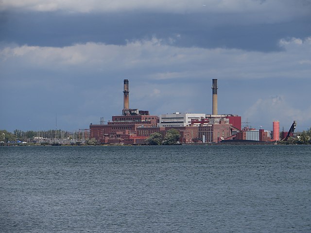
| Description | The former Charles R. Huntley Generating Station in Tonawanda, New York, as seen in September 2016. Installed in 1916 by the Buffalo General Electric Company and at first known as the "River Station", this was a coal-fired power plant built to supplement the hydroelectric station at Niagara Falls during a time when electricity was rapidly becoming de rigueur for middle-class households, and demand for energy was skyrocketing at a pace that one can imagine was hard to keep up with. The three steam turbines it boasted at the outset, each capable of generating 20 megawatts of power, were fed by coal that arrived principally via the New York Central Railroad, from whose main tracks parallel to Military Road a branch extended here. There was also once a small lighthouse nearby that guided lake freighters loaded with coal to the plant. Renamed the Charles R. Huntley Station in 1926 after the recently deceased president of the Buffalo General Electric Company, the plant's capacity was expanded with a new turbine added in each of the years 1919, 1926, 1928, and 1930, eventually topping out at 760 megawatts of electricity. The plant continued in operation under a chain of successor companies, and in the middle 20th century the plume of coal smoke emanating from its stacks would regularly reach Williamsville some 10 miles to the east; despite continuing efforts to remedy the situation with installation of emission controls in the smokestacks, it was still the fifth-largest single source of air pollution in New York State as of 1999. Huntley was one of the last remaining coal-fired power plants in New York in 2005, when - due to low natural gas prices - its then-owner NRG Energy began a staggered shutdown of its generators, a process that ended when the last two were decommissioned in 2015. The property has been for sale since then. |
| Date | |
| Source | Huntley Station, Tonawanda, New York |
| Author | Ken Lund from Reno, Nevada, USA |
| Camera location | | View this and other nearby images on: OpenStreetMap |
|---|
.jpg¶ms=042.942338_N_-078.926214_E_globe:Earth_type:camera_source:Flickr_&language=en)
Licensing[edit]
.jpg&action=edit§ion=2)
This file is licensed under the Creative Commons Attribution-Share Alike 2.0 Generic license.
- You are free:
- to share – to copy, distribute and transmit the work
- to remix – to adapt the work
- Under the following conditions:
- attribution – You must give appropriate credit, provide a link to the license, and indicate if changes were made. You may do so in any reasonable manner, but not in any way that suggests the licensor endorses you or your use.
- share alike – If you remix, transform, or build upon the material, you must distribute your contributions under the same or compatible license as the original.
| This image was originally posted to Flickr by Ken Lund at https://flickr.com/photos/75683070@N00/29358753473. It was reviewed on 10 March 2022 by FlickreviewR 2 and was confirmed to be licensed under the terms of the cc-by-sa-2.0. |
File history
Click on a date/time to view the file as it appeared at that time.
| Date/Time | Thumbnail | Dimensions | User | Comment | |
|---|---|---|---|---|---|
| current | 19:20, 10 March 2022 | | 4,000 × 3,000 (3.05 MB) | Mindmatrix (talk | contribs) | Transferred from Flickr via #flickr2commons |
You cannot overwrite this file.
File usage on Commons
There are no pages that use this file.
.jpg&oldid=734371993)