File:Hurricane Fabian 02 sept 2003.jpg
跳转到导航
跳转到搜索

本预览的尺寸:458 × 599像素。 其他分辨率:183 × 240像素 | 367 × 480像素 | 587 × 768像素 | 783 × 1,024像素 | 1,566 × 2,048像素 | 5,200 × 6,800像素。
原始文件 (5,200 × 6,800像素,文件大小:5.19 MB,MIME类型:image/jpeg)
说明
说明
添加一行文字以描述该文件所表现的内容
摘要
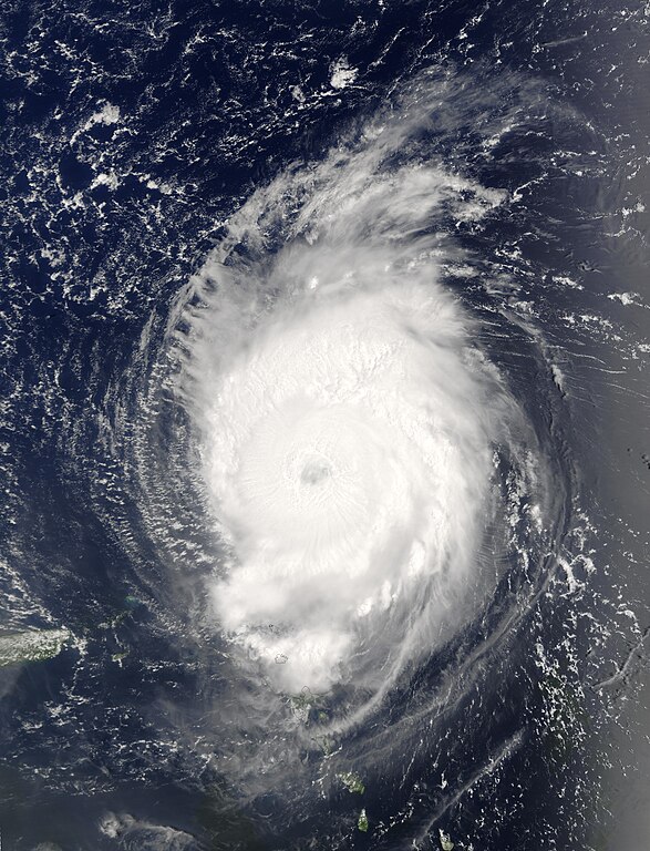
[编辑]| 描述 | The MODIS instrument onboard NASA's Terra spacecraft captured this bird's-eye view of Hurricane Fabian in the Atlantic Ocean. In this image Fabian is located about 190 miles north-northeast of Barbuda in the northern Leeward Islands. Fabian is a Category 4 storm on the Saffir-Simpson Scale and is packing sustained winds of 140 mph with higher gusts. The National Hurricane Center expects Fabian to continue on a west-northwest path at 10 mph for the next 24 hours. | |||||
| 日期 | ||||||
| 来源 | http://visibleearth.nasa.gov/view_rec.php?id=5736 | |||||
| 作者 | Jacques Descloitres, MODIS Rapid Response Team, NASA/GSFC | |||||
| 授权 (二次使用本文件) |
|
|||||
| 其他版本 | Image:Hurricane fabian 2003.jpg |

文件历史
点击某个日期/时间查看对应时刻的文件。
| 日期/时间 | 缩略图 | 大小 | 用户 | 备注 | |
|---|---|---|---|---|---|
| 当前 | 2006年9月29日 (五) 15:45 | | 5,200 × 6,800(5.19 MB) | Good kitty(留言 | 贡献) | == Summary == {{Information |Description=The MODIS instrument onboard NASA's Terra spacecraft captured this bird's-eye view of Hurricane Fabian in the Atlantic Ocean. In this image Fabian is located about 190 miles north-northeast of Barbuda in the northe |
您不可以覆盖此文件。
文件用途
以下2个页面使用本文件:
全域文件用途
以下其他wiki使用此文件:
- ca.wikipedia.org上的用途
- en.wikipedia.org上的用途
- eo.wikipedia.org上的用途
- fr.wikipedia.org上的用途
- simple.wikipedia.org上的用途
- tl.wikipedia.org上的用途
- www.wikidata.org上的用途
- zh.wikipedia.org上的用途