File:Hurricane Fefa.JPG
Jump to navigation
Jump to search
No higher resolution available.
Hurricane_Fefa.JPG (497 × 475 pixels, file size: 28 KB, MIME type: image/jpeg)
Captions
Captions
Add a one-line explanation of what this file represents
Summary
[edit]| Description |
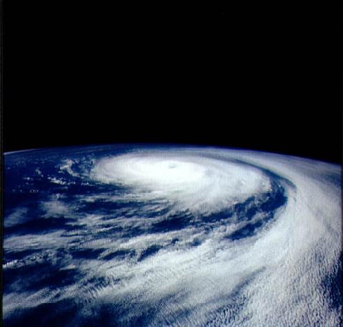
English: This oblique view of Hurricane Fefa shows the full extent of this storm with a cloud gyre several hundred miles in diameter and an elevated segment around the eye. The elevated segment bordering the eye indicates a tightly formed gyre with high internal wind speeds. At the time of this exposure, Fefa was located between the California coast and Hawaii. Fefa eventually dissipated at sea, failing to make landfall and thus did no property damage. |
|||||
| Date | ||||||
| Source | here | |||||
| Author | NASA | |||||
| Permission (Reusing this file) |
|

File history
Click on a date/time to view the file as it appeared at that time.
| Date/Time | Thumbnail | Dimensions | User | Comment | |
|---|---|---|---|---|---|
| current | 22:43, 22 December 2006 | | 497 × 475 (28 KB) | Juan andrés (talk | contribs) | {{Information |Description= This oblique view of Hurricane Fefa shows the full extent of this storm with a cloud gyre several hundred miles in diameter and an elevated segment around the eye. The elevated segment bordering the eye indicates a tightly form |
You cannot overwrite this file.
File usage on Commons
There are no pages that use this file.
File usage on other wikis
The following other wikis use this file:
- Usage on en.wikipedia.org