File:Hurricane Paula 2010-10-12 1620Z.jpg
跳至導覽
跳至搜尋
預覽大小:600 × 600 像素。 其他解析度:240 × 240 像素 | 480 × 480 像素 | 768 × 768 像素 | 1,024 × 1,024 像素 | 2,048 × 2,048 像素 | 5,600 × 5,600 像素。
原始檔案 (5,600 × 5,600 像素,檔案大小:8.06 MB,MIME 類型:image/jpeg)
說明
說明
添加單行說明來描述出檔案所代表的內容
摘要
[編輯]
| 描述 |
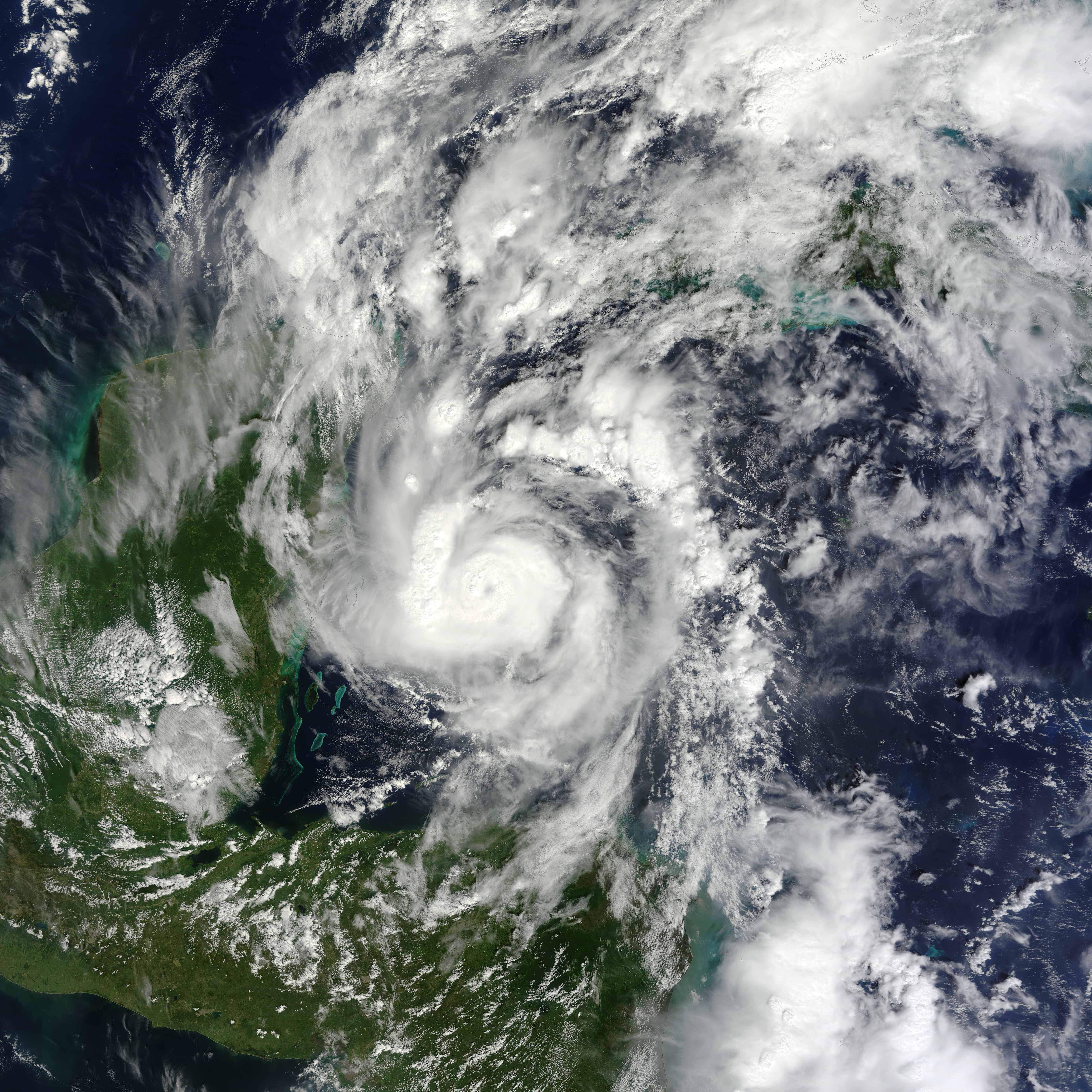
English: Small but powerful, Hurricane Paula packed winds of 100 miles (160 kilometers) per hour on October 12, 2010. At 12:45 p.m. Central Daylight Time (CDT), the U.S. National Hurricane Center (NHC) reported that Paula was a Category 2 hurricane, located roughly 140 miles (220 kilometers) south-southeast of Cozumel, Mexico, and was traveling slowly toward the north-northwest.
The Moderate Resolution Imaging Spectroradiometer (MODIS) on NASA’s Terra satellite captured this natural-color image of Hurricane Paula at 11:20 a.m. CDT (16:20 UTC) on October 12 while over the Caribbean Sea, just off the coasts of Mexico, Belize, and Honduras. Coiled around a distinct eye, the storm’s most intense clouds spanned roughly 200 kilometers (125 miles). By October 14, 2010, Paula had weakened to a tropical storm. At 10:00 a.m. CDT on October 14, the NHC reported that Paula had winds of 70 miles (110 kilometers) per hour. Though less intense than it had been two days earlier, Paula still posed hazards. A tropical storm warning was in effect for parts of Cuba, and a tropical storm watch was in effect for parts of the Florida Keys. The NHC warned of high winds and heavy rains—amounting to 10 inches (25 centimeters) in isolated areas. |
| 日期 | |
| 來源 | [1] |
| 作者 | NASA image by Jeff Schmaltz, MODIS Rapid Response Team at NASA GSFC. Caption by Michon Scott. |
授權條款
[編輯]
| 本作品由NASA創作,屬於公有領域。根據NASA的版權政策:“NASA的創作除非另有聲明否則不受版權保護。”(參見:Template:PD-USGov/zh,NASA版權政策或JPL圖像使用政策) | ||
 |
警告:
|
檔案歷史
點選日期/時間以檢視該時間的檔案版本。
| 日期/時間 | 縮圖 | 尺寸 | 用戶 | 備註 | |
|---|---|---|---|---|---|
| 目前 | 2013年6月28日 (五) 03:33 | | 5,600 × 5,600(8.06 MB) | HurricaneSpin(對話 | 貢獻) | cropped |
| 2010年10月12日 (二) 22:56 |  | 5,600 × 7,200(6.19 MB) | HurricaneSpin(對話 | 貢獻) | {{Information |Description={{en|1=Hurricane Paula.}} |Source=[http://rapidfire.sci.gsfc.nasa.gov/gallery/?2010285-1012/Paula.A2010285.1620.2km.jpg] |Author=NASA/MODIS Rapid Response System |Date=2010-10-12 |Permission=See below |other_versions= }} [[Cate |
無法覆蓋此檔案。
檔案用途
下列頁面有用到此檔案:
全域檔案使用狀況
以下其他 wiki 使用了這個檔案:
- de.wikipedia.org 的使用狀況
- en.wikipedia.org 的使用狀況
- en.wikinews.org 的使用狀況
- es.wikipedia.org 的使用狀況
- fr.wikipedia.org 的使用狀況
- ko.wikipedia.org 的使用狀況
- nl.wikipedia.org 的使用狀況
- pt.wikipedia.org 的使用狀況
- simple.wikipedia.org 的使用狀況
- www.wikidata.org 的使用狀況
- zh.wikipedia.org 的使用狀況