File:Hurricane ernesto 20060827.jpg
原始文件 (5,600 × 5,600像素,文件大小:4.15 MB,MIME类型:image/jpeg)
说明
说明
摘要[编辑]
| 描述 |
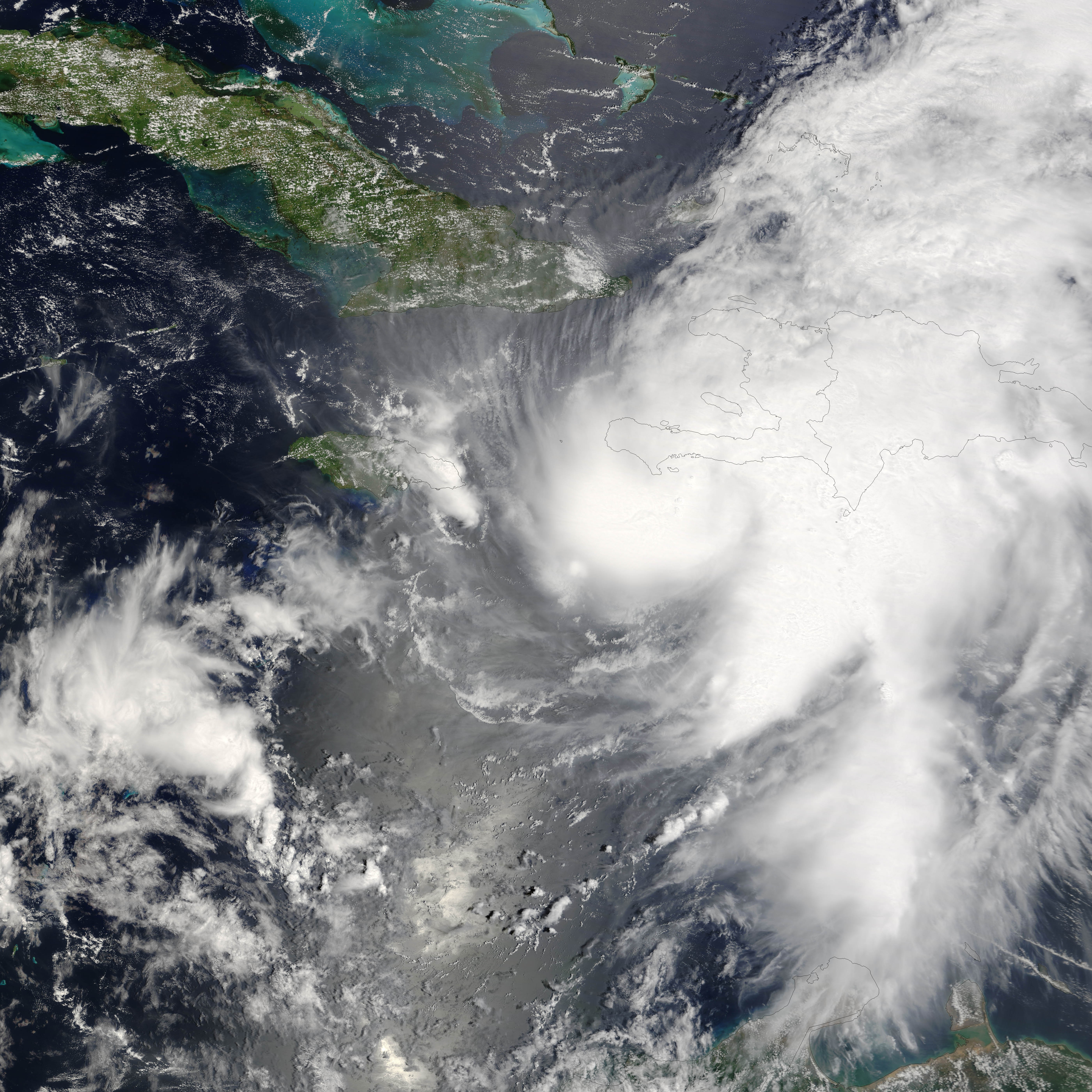
Hurricane Ernesto formed in the eastern Caribbean Sea on August 24, 2006. Within a day, it had become organized enough to be classified as a tropical storm and get named as the fifth storm of the 2006 Atlantic Season, Tropical Storm Ernesto. Ernesto built in power gradually as it moves westward and slightly north through the Caribbean Sea, just reaching hurricane strength as it neared Hispaniola (The island on which the nations of Haiti and Dominican Republic are located.) on August 27. This made it the first storm of the 2006 Atlantic season to reach hurricane strength. However, the interactions of the storm with land robbed Ernesto of enough power to sink it back to storm status again, where it is anticipated it will remain until at least after it crosses Cuba, forecast to have happened on August 28. If predictions made on August 28 hold true, the storm will travel most of the length of Cuba, then cross the Straits of Florida, possibly regaining enough power to become a hurricane again before coming ashore again in southern Florida. This photo-like image was acquired by the Moderate Resolution Imaging Spectroradiometer (MODIS) on the Terra satellite on August 27 2006, at 11:50 a.m. local time (15:50 UTC). Hurricane Ernesto at the time of this image was a well-developed storm system, but its interactions with Hispaniola had started to distort the hurricane enough to rob it of a well-defined eye. According to the University of Hawaii’s Tropical Storm information center, Ernesto had sustained peak winds of around 110 kilometers per hour (65 miles per hour) at the time Aqua MODIS acquired these data. The high-resolution image provided above is provided at the full MODIS spatial resolution (level of detail) of 250 meters per pixel. The MODIS Rapid Response System provides this image at additional resolutions. |
|||||
| 日期 | ||||||
| 来源 | http://earthobservatory.nasa.gov/NaturalHazards/natural_hazards_v2.php3?img_id=13813 | |||||
| 作者 | NASA image by Jeff Schmaltz, MODIS Rapid Response Team, Goddard Space Flight Center. | |||||
| 授权 (二次使用本文件) |
|
|||||
| 其他版本 |
Image:Ernesto 27 aug 2006 1550Z.jpg Uncropped Image:05LERNESTO 2006.jpg Grayscale version from NRL Monterey site |

文件历史
点击某个日期/时间查看对应时刻的文件。
| 日期/时间 | 缩略图 | 大小 | 用户 | 备注 | |
|---|---|---|---|---|---|
| 当前 | 2006年8月28日 (一) 16:45 | | 5,600 × 5,600(4.15 MB) | Good kitty(留言 | 贡献) | == Summary == {{Information |Description=Hurricane Ernesto formed in the eastern Caribbean Sea on August 24, 2006. Within a day, it had become organized enough to be classified as a tropical storm and get named as the fifth storm of the 2006 Atlantic Seas |
您不可以覆盖此文件。
文件用途
以下页面使用本文件:
全域文件用途
以下其他wiki使用此文件:
- de.wikipedia.org上的用途
- de.wikinews.org上的用途
- en.wikipedia.org上的用途
- en.wikinews.org上的用途
- es.wikipedia.org上的用途
- fr.wikipedia.org上的用途
- ko.wikipedia.org上的用途
- nl.wikipedia.org上的用途
- simple.wikipedia.org上的用途
- sv.wikipedia.org上的用途
- zh.wikipedia.org上的用途