File:IMG Teletckoe lake.jpg
Jump to navigation
Jump to search
Size of this preview: 399 × 599 pixels. Other resolutions: 160 × 240 pixels | 437 × 656 pixels.
Original file (437 × 656 pixels, file size: 128 KB, MIME type: image/jpeg)
Captions
Captions
Add a one-line explanation of what this file represents
Summary
[edit]
| Description |
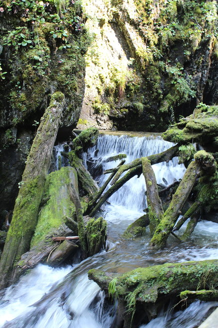
Русский: Водопад Чедор: Телецкое озеро, в приустьевой части р. Бол. Корбу, Яйлю, Турочакский район, Алтай
|
|||
| Date | Taken on 5 August 2017 | |||
| Source | Own work | |||
| Author | Mrss.victory |
| Camera location | | View this and other nearby images on: OpenStreetMap |
|---|
Licensing
[edit]
I, the copyright holder of this work, hereby publish it under the following license:
This file is licensed under the Creative Commons Attribution-Share Alike 4.0 International license.
- You are free:
- to share – to copy, distribute and transmit the work
- to remix – to adapt the work
- Under the following conditions:
- attribution – You must give appropriate credit, provide a link to the license, and indicate if changes were made. You may do so in any reasonable manner, but not in any way that suggests the licensor endorses you or your use.
- share alike – If you remix, transform, or build upon the material, you must distribute your contributions under the same or compatible license as the original.
This image was uploaded as part of Wiki Loves Earth 2018.
|
 |
File history
Click on a date/time to view the file as it appeared at that time.
| Date/Time | Thumbnail | Dimensions | User | Comment | |
|---|---|---|---|---|---|
| current | 05:53, 16 May 2018 | | 437 × 656 (128 KB) | Mrss.victory (talk | contribs) | User created page with UploadWizard |
You cannot overwrite this file.
File usage on Commons
There are no pages that use this file.