File:ION LRT map.svg
Jump to navigation
Jump to search

Size of this PNG preview of this SVG file: 649 × 558 pixels. Other resolutions: 279 × 240 pixels | 558 × 480 pixels | 893 × 768 pixels | 1,191 × 1,024 pixels | 2,382 × 2,048 pixels.
Original file (SVG file, nominally 649 × 558 pixels, file size: 678 KB)
Captions
Captions
Add a one-line explanation of what this file represents
Summary
[edit]
| Description |
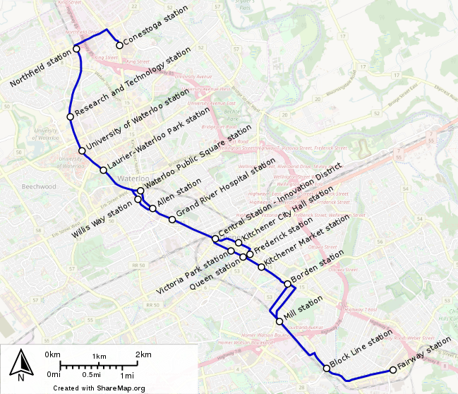
English: Map of the ION LRT. The tracks were exported from the OSM database to sharemap.org where it was exported to SVG. Because of poor track quality I rebuild all tracks by hand again
Deutsch: Liniennetzplan des ION LRTs. Die Tracks wurden aus der OSM Datenbank nach sharemap.org exportiert, wo sie als SVG exportiert wurden. Wegen schlechter Trackqualität wurden sämtlichen Tracks per Hand erneut gezogen. |
| Date | |
| Source | Own work, sharemap |
| Author | Nobelium |
| This work contains information from OpenStreetMap, which is made available under the Open Database License (ODbL).
The ODbL does not require any particular license for maps produced from ODbL data. Prior to 1 August 2020, map tiles produced by the OpenStreetMap Foundation were licensed under the CC-BY-SA-2.0 license. Maps produced by other people may be subject to other licences. |
Licensing
[edit]
This file is licensed under the Creative Commons Attribution-Share Alike 4.0 International license.
- You are free:
- to share – to copy, distribute and transmit the work
- to remix – to adapt the work
- Under the following conditions:
- attribution – You must give appropriate credit, provide a link to the license, and indicate if changes were made. You may do so in any reasonable manner, but not in any way that suggests the licensor endorses you or your use.
- share alike – If you remix, transform, or build upon the material, you must distribute your contributions under the same or compatible license as the original.
File history
Click on a date/time to view the file as it appeared at that time.
| Date/Time | Thumbnail | Dimensions | User | Comment | |
|---|---|---|---|---|---|
| current | 20:42, 13 April 2017 | | 649 × 558 (678 KB) | Nobelium (talk | contribs) | increased font size |
| 19:03, 4 April 2017 |  | 591 × 521 (674 KB) | Nobelium (talk | contribs) | {{Information |Description ={{en|1=Map of the ION LRT. The tracks were exported from the OSM database to [http://sharemap.org/public/ION sharemap.org] where it was exported to SVG. Because of poor track quality I rebuild all tracks by hand again}}... |
You cannot overwrite this file.
File usage on Commons
The following 3 pages use this file:
File usage on other wikis
The following other wikis use this file:
- Usage on en.wikipedia.org
- Usage on en.wikivoyage.org
- Usage on eo.wikipedia.org
- Usage on fr.wikipedia.org
- Usage on ja.wikipedia.org
- Usage on www.wikidata.org
- Usage on zh.wikipedia.org