File:Iceland's Mid-Atlantic Ridge during snow.jpg
跳转到导航
跳转到搜索

本预览的尺寸:800 × 483像素。 其他分辨率:320 × 193像素 | 640 × 387像素 | 1,024 × 619像素 | 1,280 × 773像素 | 2,560 × 1,546像素 | 5,975 × 3,609像素。
原始文件 (5,975 × 3,609像素,文件大小:12.02 MB,MIME类型:image/jpeg)
说明
说明
添加一行文字以描述该文件所表现的内容
摘要
[编辑]| 描述 |
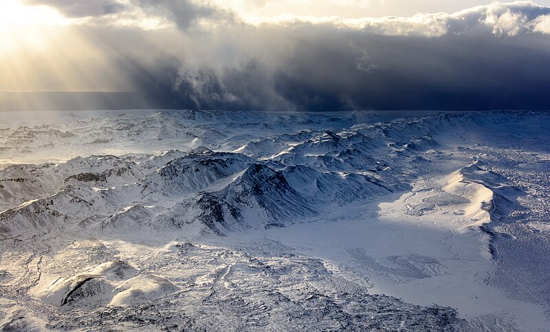
English: A shot taken from a plane over Iceland's south-western part of the mountain range caused by the Mid-Atlantic Ridge (Reykjanes Ridge). The shot is pointing towards the south-east (taken from above the sea).
Español: Foto aérea de la cadena montañosa de la península de Reykjanes en el suroeste de Islandia. La cadena montañosa es una continuación de la dorsal mesoatlántica (Reykjanes Ridge). La foto apunta hacia el sureste.
Українська: Аерознімок південно-західної частини гірського хребта Ісландії, як продовження Серединно-Атлантичного хребта (хр. Рейк'янес). |
|||
| 日期 | 摄于2018年2月6日, 14:38:59 | |||
| 来源 | 自己的作品 | |||
| 作者 |
|

| 相机位置 | | 在以下服务上查看本图像和附近其他图像: OpenStreetMap |
|---|
评价
[编辑]
This image was selected as picture of the day on Wikimedia Commons for 14 September 2022. It was captioned as follows: English: A shot taken from a plane over Iceland's south-western part of the mountain range caused by the Mid-Atlantic Ridge (Reykjanes Ridge). Other languages:
Čeština: Letecký snímek části pohoří v jihozápadní části Islandu, které je zároveň součástí geologického útvaru Středoatlantského hřbetu. Deutsch: Blick aus einem Flugzeug auf den isländischen Reykjanesrücken, Teil des Mittelatlantischer Rücken. English: A shot taken from a plane over Iceland's south-western part of the mountain range caused by the Mid-Atlantic Ridge (Reykjanes Ridge). Español: Foto aérea de la cadena montañosa de la península de Reykjanes en el suroeste de Islandia. La cadena montañosa es una continuación de la dorsal mesoatlántica (Reykjanes Ridge). La foto apunta hacia el sureste (tomada desde arriba del mar). Français : La dorsale médio-atlantique vue d'Islande. Cette chaîne de montagne est essentiellement marine : ses pics les plus élevés forment des îles à la surface de l'océan Atlantique. Magyar: Repülőgépről készült felvétel Izland délnyugati része felett, a Közép-Atlanti-hátság (Reykjanesi hátság) okozta hegyvonulatról Nederlands: Luchtfoto van het IJslandse schiereiland Reykjanes. IJsland is een deel van de Mid-Atlantische Rug dat boven water uitsteekt. Português: Foto aérea da cordilheira da península de Reykjanes no sudoeste da Islândia. A cadeia montanhosa é uma continuação da dorsal mesoatlântica. Македонски: Прелет над венецот Рејкјанес во Исланд предизвикан од Средноатлантскиот Гребен. Українська: Аерознімок південно-західної частини гірського хребта Ісландії, як продовження Серединно-Атлантичного хребта (хр. Рейк'янес). |
|
|
许可协议
[编辑]
本文件采用知识共享署名-相同方式共享 4.0 国际许可协议授权。
署名: Bar Harel
- 您可以自由地:
- 共享 – 复制、发行并传播本作品
- 修改 – 改编作品
- 惟须遵守下列条件:
- 署名 – 您必须对作品进行署名,提供授权条款的链接,并说明是否对原始内容进行了更改。您可以用任何合理的方式来署名,但不得以任何方式表明许可人认可您或您的使用。
- 相同方式共享 – 如果您再混合、转换或者基于本作品进行创作,您必须以与原先许可协议相同或相兼容的许可协议分发您贡献的作品。
文件历史
点击某个日期/时间查看对应时刻的文件。
| 日期/时间 | 缩略图 | 大小 | 用户 | 备注 | |
|---|---|---|---|---|---|
| 当前 | 2018年6月16日 (六) 12:05 | | 5,975 × 3,609(12.02 MB) | Bharel(留言 | 贡献) | less NR |
| 2018年6月16日 (六) 11:43 |  | 5,975 × 3,609(11.9 MB) | Bharel(留言 | 贡献) | I need an IPS screen for dust spots. Resampled spots, reduced noise filter for bottom to preserve detail, added noise filter for top. | |
| 2018年6月16日 (六) 00:32 |  | 5,975 × 3,609(11.71 MB) | Bharel(留言 | 贡献) | sRGB | |
| 2018年6月16日 (六) 00:19 |  | 5,975 × 3,609(11.2 MB) | Bharel(留言 | 贡献) | Changed colorspace to AdobeRGB due to posterization | |
| 2018年6月15日 (五) 22:41 |  | 5,975 × 3,609(10.91 MB) | Bharel(留言 | 贡献) | Removed blob | |
| 2018年6月15日 (五) 22:31 |  | 5,975 × 3,609(10.92 MB) | Bharel(留言 | 贡献) | Super tiny denoise filter, hopefully won't hurt the overall quality and sharpness. | |
| 2018年6月15日 (五) 16:14 |  | 5,975 × 3,609(11.72 MB) | Bharel(留言 | 贡献) | User created page with UploadWizard |
您不可以覆盖此文件。
文件用途
以下35个页面使用本文件:
- User:Andrew J.Kurbiko/POTD/2022
- User:Eatcha/POTY-2018-Round-1-Results
- User:Geagea/Israel/2018 June 16
- User talk:Bharel
- Commons:Featured picture candidates/File:Iceland's Mid-Atlantic Ridge during snow.jpg
- Commons:Featured picture candidates/Log/June 2018
- Commons:Featured pictures/Places/Natural/Iceland
- Commons:Featured pictures/chronological/2018-A
- Commons:Picture of the Year/2018/Candidates
- Commons:Picture of the Year/2018/R1/Gallery/2018-A
- Commons:Picture of the Year/2018/R1/Gallery/ALL
- Commons:Picture of the Year/2018/R1/Gallery/M06
- Commons:Picture of the Year/2018/R1/Gallery/Nature views
- Commons:Picture of the Year/2018/R1/v/Iceland's Mid-Atlantic Ridge during snow.jpg
- Commons:Quality images/Subject/Places/Natural structures/archive 2018
- Commons:Quality images candidates/Archives June 18 2018
- File:Iceland's snowy mountains.jpg(文件重定向)
- Template:Potd/2022-09
- Template:Potd/2022-09-14
- Template:Potd/2022-09-14 (cs)
- Template:Potd/2022-09-14 (de)
- Template:Potd/2022-09-14 (en)
- Template:Potd/2022-09-14 (es)
- Template:Potd/2022-09-14 (fr)
- Template:Potd/2022-09-14 (hu)
- Template:Potd/2022-09-14 (mk)
- Template:Potd/2022-09-14 (myv)
- Template:Potd/2022-09-14 (nl)
- Template:Potd/2022-09-14 (pt)
- Template:Potd/2022-09-14 (pt-br)
- Template:Potd/2022-09-14 (uk)
全域文件用途
以下其他wiki使用此文件:
- alt.wikipedia.org上的用途
- av.wikipedia.org上的用途
- be-tarask.wikipedia.org上的用途
- bn.wikipedia.org上的用途
- cv.wikipedia.org上的用途
- en.wikipedia.org上的用途
- fr.wikipedia.org上的用途
- he.wikipedia.org上的用途
- hu.wikipedia.org上的用途
- jv.wikipedia.org上的用途
- kk.wikipedia.org上的用途
- ko.wikipedia.org上的用途
- lbe.wikipedia.org上的用途
- lez.wikipedia.org上的用途
- mhr.wikipedia.org上的用途
- mk.wikipedia.org上的用途
- os.wikipedia.org上的用途
- pt.wikipedia.org上的用途
- ru.wikipedia.org上的用途
- sah.wikipedia.org上的用途
- uk.wikipedia.org上的用途
- uz.wikipedia.org上的用途
- vep.wikipedia.org上的用途
- zh.wikipedia.org上的用途