File:Idrisids-eng.PNG
跳至導覽
跳至搜尋
預覽大小:800 × 512 像素。 其他解析度:320 × 205 像素 | 640 × 409 像素 | 1,113 × 712 像素。
原始檔案 (1,113 × 712 像素,檔案大小:47 KB,MIME 類型:image/png)
說明
說明
添加單行說明來描述出檔案所代表的內容
| 描述 | |
| 來源 | 自己的作品 |
| 作者 | Omar-Toons |
| 授權許可 (重用此檔案) |
此檔案採用創用CC 姓名標示 1.0 通用版授權條款。
|
| 其他版本 |
.gif)
檔案歷史
點選日期/時間以檢視該時間的檔案版本。
| 日期/時間 | 縮圖 | 尺寸 | 用戶 | 備註 | |
|---|---|---|---|---|---|
| 目前 | 2014年10月17日 (五) 21:36 | | 1,113 × 712(47 KB) | Omar-toons(對話 | 貢獻) | min. ch. |
| 2014年10月2日 (四) 16:20 |  | 1,113 × 712(47 KB) | Omar-toons(對話 | 貢獻) | Reverted to version as of 16:44, 25 December 2011 | |
| 2014年7月9日 (三) 23:18 |  | 3,006 × 1,949(500 KB) | Nastoshka(對話 | 貢獻) | New map, extracted from the svg version. | |
| 2011年12月25日 (日) 16:44 |  | 1,113 × 712(47 KB) | Omar-Toons(對話 | 貢獻) | col. + crop | |
| 2011年8月26日 (五) 03:23 |  | 1,276 × 854(54 KB) | Omar-Toons(對話 | 貢獻) | last reference added (acc. to) | |
| 2010年5月18日 (二) 13:12 |  | 1,276 × 854(54 KB) | Omar-Toons(對話 | 貢獻) | missed "e" 's | |
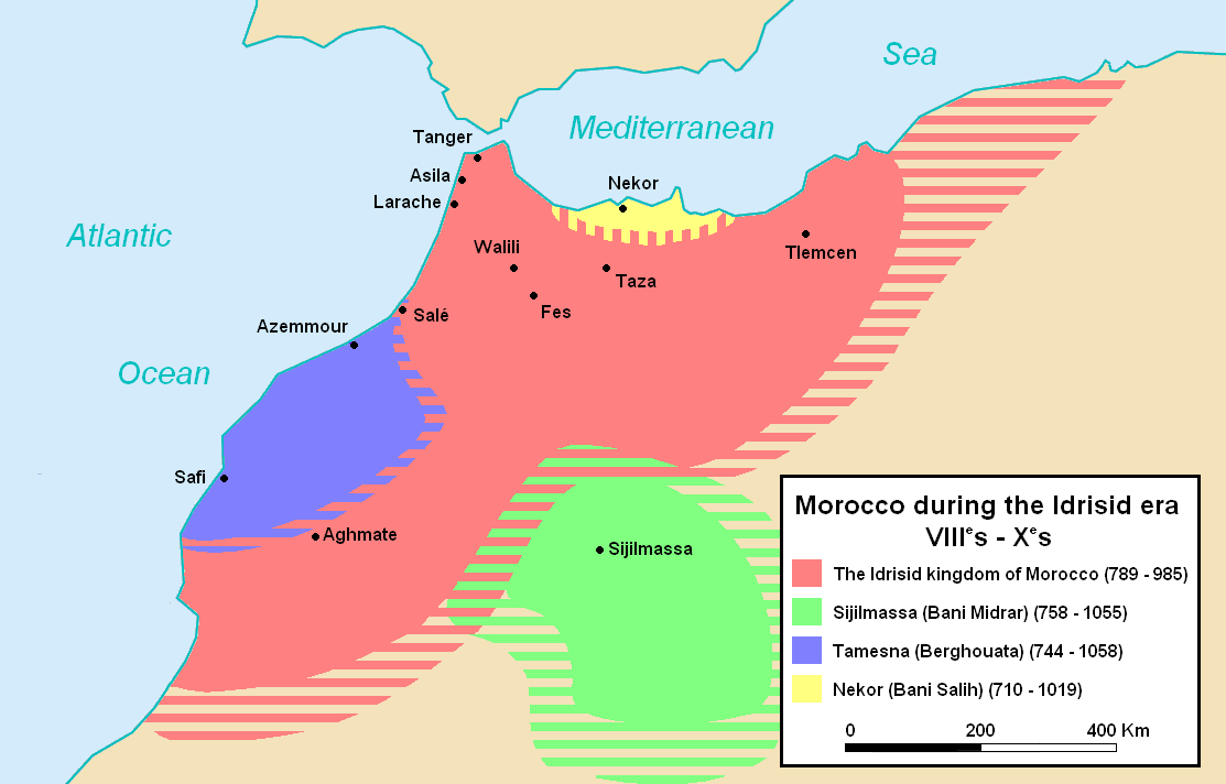
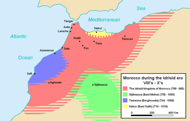
| 2010年5月18日 (二) 13:10 |  | 1,276 × 854(54 KB) | Omar-Toons(對話 | 貢獻) | {{Information |Description={{en|1=Map of Morocco during the idrissid era. Refs: Euratlas maps [http://www.euratlas.net/history/europe/800/fr_800_sud-ouest.html][http://www.euratlas.net/history/europe/900/fr_900_sud-ouest.html] and Shepherd's works [http |
無法覆蓋此檔案。
檔案用途
下列3個頁面有用到此檔案:
全域檔案使用狀況
以下其他 wiki 使用了這個檔案:
- an.wikipedia.org 的使用狀況
- ar.wikipedia.org 的使用狀況
- arz.wikipedia.org 的使用狀況
- ast.wikipedia.org 的使用狀況
- az.wikipedia.org 的使用狀況
- ba.wikipedia.org 的使用狀況
- bn.wikipedia.org 的使用狀況
- bs.wikipedia.org 的使用狀況
- ca.wikipedia.org 的使用狀況
- cs.wikipedia.org 的使用狀況
- de.wikipedia.org 的使用狀況
- el.wikipedia.org 的使用狀況
- en.wikipedia.org 的使用狀況
- et.wikipedia.org 的使用狀況
- eu.wikipedia.org 的使用狀況
- fa.wikipedia.org 的使用狀況
- fi.wikipedia.org 的使用狀況
- ha.wikipedia.org 的使用狀況
- hr.wikipedia.org 的使用狀況
- hu.wikipedia.org 的使用狀況
- id.wikipedia.org 的使用狀況
- it.wikipedia.org 的使用狀況
- ja.wikipedia.org 的使用狀況
- ka.wikipedia.org 的使用狀況
- ko.wikipedia.org 的使用狀況
- ml.wikipedia.org 的使用狀況
- mt.wikipedia.org 的使用狀況
檢視此檔案的更多全域使用狀況。