File:Ifpo 22237 Syrie, gouvernorat d'Idlib, district de Harim, Tall Aqibrin, vue aérienne oblique.jpg
Jump to navigation
Jump to search

Size of this preview: 799 × 599 pixels. Other resolutions: 320 × 240 pixels | 640 × 480 pixels | 1,024 × 768 pixels | 1,280 × 960 pixels | 2,098 × 1,574 pixels.
Original file (2,098 × 1,574 pixels, file size: 475 KB, MIME type: image/jpeg)
Captions
Captions
Add a one-line explanation of what this file represents
| Photographer |
|
|||||||||||
| Description |
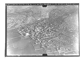
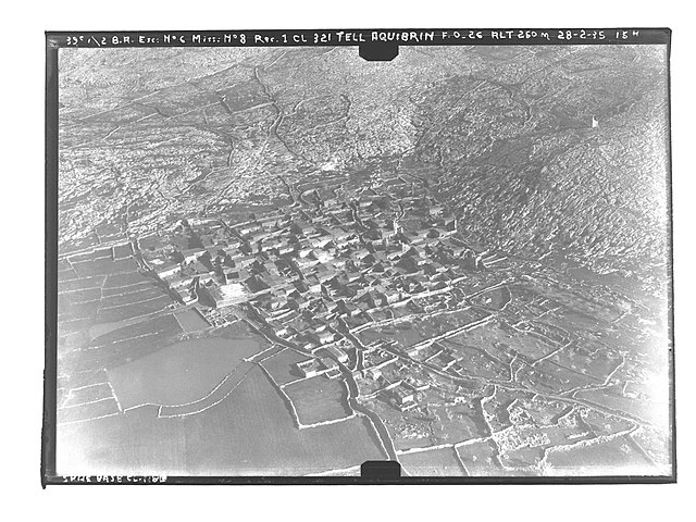
Français : Syrie, gouvernorat d'Idlib, district de Harim, Tall Aqibrin, vue aérienne oblique |
|||||||||||
| Date |
Taken on 28 February 1935 16 March 2020, 10:55:40 (upload date) |
|||||||||||
| Medium | dry plate | |||||||||||
| Dimensions | height: 13 cm (5.1 in); width: 18 cm (7 in) | |||||||||||
| Collection |
|
|||||||||||
| Accession number |
hal-02508890 Ifpo-22237 |
|||||||||||
| Object history | French army | |||||||||||
| Credit line |
Français : Institut français du Proche-Orient (Ifpo) ; ALIPH – Alliance internationale pour la protection du patrimoine dans les zones en conflit |
|||||||||||
| Source |
https://hal.archives-ouvertes.fr/hal-02508890 https://hal.archives-ouvertes.fr/hal-02508890/document |
|||||||||||
| Permission (Reusing this file) |
|
|||||||||||
| Mots-clés | Français : District de Harim,Archéologie,Syrie,Photographie aérienne oblique,Vue aérienne,Photographie aérienne,Gouvernorat d'Idlib,Tell Aaqibrîne,Tell Akabrine,Tall `Aqibrīn,Tall Aqibrin,Tell Aqibrin,Tell Aquibrin,Tal Alkarama,Tell Elkaramé,Tall al-Karāmah,Tell al-Kerameh,Tall al-Karāmah ʿAqibryn,Nahiyah Al-Dana,Canton d'Al-Dana |
|||||||||||
| Camera location | | View this and other nearby images on: OpenStreetMap |
|---|
File history
Click on a date/time to view the file as it appeared at that time.
| Date/Time | Thumbnail | Dimensions | User | Comment | |
|---|---|---|---|---|---|
| current | 21:05, 18 April 2021 | | 2,098 × 1,574 (475 KB) | Don-vip (talk | contribs) | pattypan 20.04 |
You cannot overwrite this file.
File usage on Commons
The following page uses this file:
File usage on other wikis
The following other wikis use this file:
- Usage on en.wikipedia.org