File:Iglesia de la Flagelación 03.JPG

Original file (2,736 × 3,648 pixels, file size: 2.09 MB, MIME type: image/jpeg)
Captions
Captions
Summary[edit]
| Description |
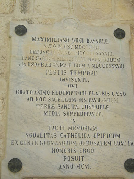
עברית: קפלה בעיר העתיקה בירושלים, שנמצאת בתחנה השנייה ב"דרך הייסורים". הקפלה מנציחה את השפלתו של ישו בידי החיילים הרומאים.
Maximilian's report of his journey, published in 1839, does not mention the site of the Flagellation at all, cf. p. 207-225 Deutsch: Maximilian, dem Herzog in Bayern / geboren am 4. Dezember 1808, / verstorben am 15. November 1888, / der diese heilige Stadt Jerusalem / vom 9. bis zum 15. Mai 1838 / zur Zeit der Pest / besuchte, / und / aus Dankbarkeit gegenüber dem mit Geißeln geschlagenen Erlöser / zur Wiederherstellung dieser Kapelle / der Kustodie des Heiligen Landes / Mittel zur Verfügung stellte, / hat zur / Erinnerung daran / die katholische Handwerkerzunft / die sich aus dem deutschen Volk in Jerusalem zusammenfand / ihm zu Ehren / dies errichtet / im Jahre 1900. |
||||
| Date | |||||
| Source | Own work | ||||
| Author | Remux |
| Camera location | | View this and other nearby images on: OpenStreetMap |
|---|
Licensing[edit]
- You are free:
- to share – to copy, distribute and transmit the work
- to remix – to adapt the work
- Under the following conditions:
- attribution – You must give appropriate credit, provide a link to the license, and indicate if changes were made. You may do so in any reasonable manner, but not in any way that suggests the licensor endorses you or your use.
- share alike – If you remix, transform, or build upon the material, you must distribute your contributions under the same or compatible license as the original.

|
This image was uploaded as part of Wiki Loves Monuments 2013.
|
 |
File history
Click on a date/time to view the file as it appeared at that time.
| Date/Time | Thumbnail | Dimensions | User | Comment | |
|---|---|---|---|---|---|
| current | 05:03, 18 September 2013 | | 2,736 × 3,648 (2.09 MB) | Remux (talk | contribs) | User created page with UploadWizard |
You cannot overwrite this file.
File usage on Commons
The following page uses this file:
File usage on other wikis
The following other wikis use this file:
- Usage on de.wikipedia.org