File:Iles Eparses-CIA WFB Map.png
Naviqasiyaya keç
Axtarışa keç

Sınaq göstərişi ölçüsü: 468 × 600 piksel. Digər ölçülər: 187 × 240 piksel | 569 × 729 piksel.
Faylın orijinalı (569 × 729 piksel, fayl həcmi: 27 KB, MIME növü: image/png)
Captions
Captions
Add a one-line explanation of what this file represents
Xülasə[redaktə]
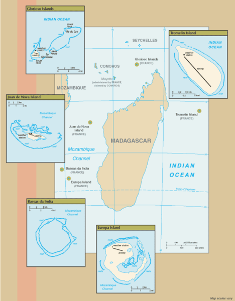
New map of Iles Eparses from 7 Sept 06 rev. of the World Factbook: https://www.cia.gov/cia/publications/factbook/geos/zz.html archive copy at the Wayback Machine
Lisenziya[redaktə]
This image is in the public domain because it contains materials that originally came from the United States Central Intelligence Agency's World Factbook.
|
 |
Faylın tarixçəsi
Faylın əvvəlki versiyasını görmək üçün gün/tarix bölməsindəki tarixlərə klikləyin.
| Tarix/Vaxt | Kiçik şəkil | Ölçülər | İstifadəçi | Şərh | |
|---|---|---|---|---|---|
| indiki | 16:07, 8 sentyabr 2006 | | 569 × 729 (27 KB) | Hoshie (müzakirə | töhfələr) | ==Summary== New map of Iles Eparses from 7 Sept 06 rev. of the World Factbook: [https://www.cia.gov/cia/publications/factbook/geos/zz.html https://www.cia.gov/cia/publications/factbook/geos/zz.html] ==Licensing== {{PD-USGov-CIA-WF}} |
Siz bu faylı yenidən yükləyə bilməzsiniz.
Fayl keçidləri
Aşağıdakı səhifə bu faylı istifadə edir:
Faylın qlobal istifadəsi
Bu fayl aşağıdakı vikilərdə istifadə olunur:
- az.wikipedia.org layihəsində istifadəsi
- en.wikipedia.org layihəsində istifadəsi
- es.wikipedia.org layihəsində istifadəsi
- fa.wikipedia.org layihəsində istifadəsi
- fr.wikipedia.org layihəsində istifadəsi
- fr.wiktionary.org layihəsində istifadəsi
- gcr.wikipedia.org layihəsində istifadəsi
- hi.wikipedia.org layihəsində istifadəsi
- id.wikipedia.org layihəsində istifadəsi
- ka.wikipedia.org layihəsində istifadəsi
- ko.wikipedia.org layihəsində istifadəsi
- lv.wikipedia.org layihəsində istifadəsi
- mg.wikipedia.org layihəsində istifadəsi
- pnb.wikipedia.org layihəsində istifadəsi
- simple.wikipedia.org layihəsində istifadəsi
- sr.wikipedia.org layihəsində istifadəsi
- sv.wikipedia.org layihəsində istifadəsi
- uk.wikipedia.org layihəsində istifadəsi
- ur.wikipedia.org layihəsində istifadəsi
- zh.wikipedia.org layihəsində istifadəsi