File:Improbable Geyser erupting (14 August 2010) 10.jpg

Original file (3,008 × 2,000 pixels, file size: 2.86 MB, MIME type: image/jpeg)
Captions
Captions
Summary
[edit]_10.jpg&action=edit§ion=1)
| Description |
English: The temperature scale is in degrees Fahrenheit.
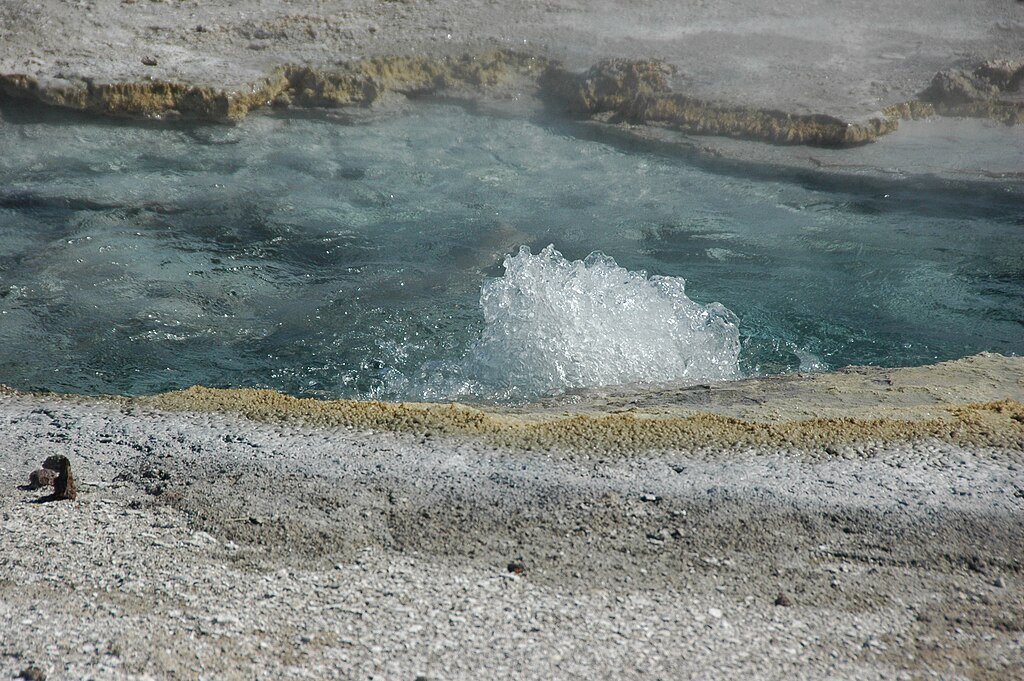
Improbable Geyser is currently a perpetual spouter in the southern Geyser Hill Group of Yellowstone's Upper Geyser Basin. It is located 14 meters southwest of Big Anemone Geyser. Improbable Geyser erupts from a pool about 3 to 4 meters in diameter. A continuous, irregularly-scalloped geyserite border decorated with small nodules encircles Improbable Geyser’s pool on its northern, eastern, and southeastern sides. Geyserite is a friable to solid chemical sedimentary rock composed of opal (hydrous silica, a.k.a. opaline silica: SiO2•nH2O), It forms by precipitation of hydrous silica from hot spring water. Geyserite is the dominant material at & around Yellowstone hot springs and geysers (the Mammoth Hot Springs area is a major exception to this). The silica in the geyserite is ultimately derived from leaching of subsurface, late Cenozoic-aged rhyolitic rocks by superheated groundwater. Rhyolite is an abundant rock at Yellowstone. The southwestern side of Improbable Geyser’s pool lacks a border and has irregularly-distributed, small mounds of geyserite. This borderless portion of the feature represents the start of its overflow channel. Eruption runoff drains to the southwest and west into the Firehole River. Improbable Geyser currently engages in low to moderately low perpetual spouting behavior from a vent in the northwestern part of the pool. This feature first had eruptions in fall 2005. Slightly violent vent enlargement events resulted in geyserite debris occurring around the geyser. A runoff channel from the geyser to the Firehole River first developed at this time. Reported activity of Improbable Geyser during October and November 2005 involved eruption columns up to an estimated 20 feet high. |
| Date | |
| Source | https://www.flickr.com/photos/47445767@N05/13417930584/ |
| Author | James St. John |
Licensing
[edit]_10.jpg&action=edit§ion=2)
- You are free:
- to share – to copy, distribute and transmit the work
- to remix – to adapt the work
- Under the following conditions:
- attribution – You must give appropriate credit, provide a link to the license, and indicate if changes were made. You may do so in any reasonable manner, but not in any way that suggests the licensor endorses you or your use.
| This image was originally posted to Flickr by James St. John at https://flickr.com/photos/47445767@N05/13417930584. It was reviewed on 28 February 2023 by FlickreviewR 2 and was confirmed to be licensed under the terms of the cc-by-2.0. |
File history
Click on a date/time to view the file as it appeared at that time.
| Date/Time | Thumbnail | Dimensions | User | Comment | |
|---|---|---|---|---|---|
| current | 20:23, 28 February 2023 | | 3,008 × 2,000 (2.86 MB) | Ser Amantio di Nicolao (talk | contribs) | Uploaded a work by James St. John from https://www.flickr.com/photos/47445767@N05/13417930584/ with UploadWizard |
You cannot overwrite this file.
File usage on Commons
There are no pages that use this file.
_10.jpg&oldid=891198678)