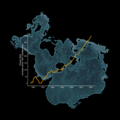
File:Increase in Ocean Heat since 1957 Map - Spilhaus Projection (SVS5111 - OceanHeatGraph).png
From Wikimedia Commons, the free media repository
Jump to navigation
Jump to search

Size of this preview: 750 × 600 pixels. Other resolutions: 300 × 240 pixels | 600 × 480 pixels | 960 × 768 pixels | 1,280 × 1,024 pixels | 1,800 × 1,440 pixels.
Original file (1,800 × 1,440 pixels, file size: 71 KB, MIME type: image/png)
File information
Structured data
Captions
Captions
A graph of ocean heat content changes since 1957. Each data point represents a five-year average.
Summary[edit]
| DescriptionIncrease in Ocean Heat since 1957 Map - Spilhaus Projection (SVS5111 - OceanHeatGraph).png |
English: A graph of ocean heat content changes since 1957. Each data point represents a five-year average. |
| Date | 16 June 2023 (upload date) |
| Source | Increase in Ocean Heat since 1957 Map - Spilhaus Projection |
| Author | NASA's Scientific Visualization Studio - Michala Garrison, Mark SubbaRao, Ian Jones, Laurence Schuler |
| Other versions |
|
| Keywords InfoField | Earth Science; Ocean Temperature; Oceans; Earth Information Center |
Licensing[edit]
| Public domainPublic domainfalsefalse |
| This file is in the public domain in the United States because it was solely created by NASA. NASA copyright policy states that "NASA material is not protected by copyright unless noted". (See Template:PD-USGov, NASA copyright policy page or JPL Image Use Policy.) |  | |
 |
Warnings:
|
File history
Click on a date/time to view the file as it appeared at that time.
| Date/Time | Thumbnail | Dimensions | User | Comment | |
|---|---|---|---|---|---|
| current | 10:19, 6 September 2023 |  | 1,800 × 1,440 (71 KB) | OptimusPrimeBot (talk | contribs) | #Spacemedia - Upload of https://svs.gsfc.nasa.gov/vis/a000000/a005100/a005111/OceanHeatGraph.png via Commons:Spacemedia |
You cannot overwrite this file.
File usage on Commons
The following 2 pages use this file:
Metadata
This file contains additional information such as Exif metadata which may have been added by the digital camera, scanner, or software program used to create or digitize it. If the file has been modified from its original state, some details such as the timestamp may not fully reflect those of the original file. The timestamp is only as accurate as the clock in the camera, and it may be completely wrong.
| Software used | |
|---|---|
| Horizontal resolution | 70.87 dpc |
| Vertical resolution | 70.87 dpc |
Structured data
Items portrayed in this file
depicts
image/png
1,440 pixel
1,800 pixel
72,558 byte
0114fda87274a191575f035c564fe401d5152448
16 June 2023
2jv5o2i7toysb832fcr5qa4ndetpiyrb7tf66uwmarin6pfkws
Hidden categories:

