File:Index map Series L792.jpg
ナビゲーションに移動
検索に移動

このプレビューのサイズ: 410 × 599 ピクセル。 その他の解像度: 164 × 240 ピクセル | 328 × 480 ピクセル | 526 × 768 ピクセル | 701 × 1,024 ピクセル | 2,200 × 3,214 ピクセル。
元のファイル (2,200 × 3,214 ピクセル、ファイルサイズ: 967キロバイト、MIME タイプ: image/jpeg)
キャプション
キャプション
このファイルの内容を1行で記述してください
概要
[編集]
| 解説 |
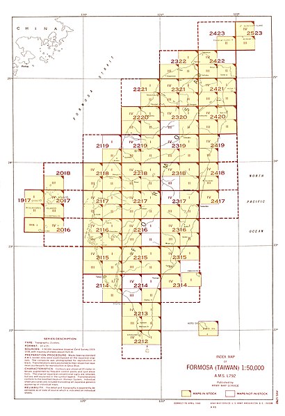
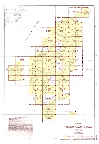
English: Index Map for AMS Series L792 (Note: Although in this index map map sheet 2214 I is not shown as a map in stock, the map was published in December 1944 and would have existed at the time this index map was created.) |
| 日付 | |
| 原典 | Courtesy of the University of Texas Libraries, The University of Texas at Austin. |
| 作者 | Army Map Serivce, Corps of Engineers |
ライセンス
[編集]
This image or file is a work of a U.S. Army Corps of Engineers soldier or employee, taken or made as part of that person's official duties. As a work of the U.S. federal government, the image is in the public domain.
|
| 注釈 | この画像には注釈がついています: コモンズで注釈を見る |
ファイルの履歴
過去の版のファイルを表示するには、その版の日時をクリックしてください。
| 日付と時刻 | サムネイル | 寸法 | 利用者 | コメント | |
|---|---|---|---|---|---|
| 現在の版 | 2019年10月20日 (日) 07:48 | | 2,200 × 3,214(967キロバイト) | Geographyinitiative(トーク | 投稿記録) | User created page with UploadWizard |
このファイルは上書きできません。
ファイルの使用状況
以下の 19 ページがこのファイルを使用しています:
- File:Txu-pclmaps-oclc-6550512-byobi-to-2212-iv.jpg
- File:Txu-pclmaps-oclc-6550512-gaian-1917-i.jpg
- File:Txu-pclmaps-oclc-6550512-garan-bi-2212-i.jpg
- File:Txu-pclmaps-oclc-6550512-hana-shima-1917-ii.jpg
- File:Txu-pclmaps-oclc-6550512-kitsubai-to-2018-iii.jpg
- File:Txu-pclmaps-oclc-6550512-kosei-to-2017-iii.jpg
- File:Txu-pclmaps-oclc-6550512-koshun-2213-iii.jpg
- File:Txu-pclmaps-oclc-6550512-koto-sho-2413-iii.jpg
- File:Txu-pclmaps-oclc-6550512-mako-2017-iv.jpg
- File:Txu-pclmaps-oclc-6550512-o-shima-1916-i.jpg
- File:Txu-pclmaps-oclc-6550512-shinka-2116-ii.jpg
- File:Txu-pclmaps-oclc-6550512-tansui-2322-i.jpg
- File:Txu-pclmaps-oclc-6550512-to-kichi-to-2016-iv.jpg
- File:Txu-pclmaps-oclc-6550514-hoka-sho-2523-iv.jpg
- File:Txu-pclmaps-oclc-6550514-kahei-sho-2423-ii.jpg
- File:Txu-pclmaps-oclc-6550514-menka-sho-2523-iii.jpg
- File:Txu-pclmaps-oclc-6550514-rato-2421-ii.jpg
- File:Txu-pclmaps-oclc-6550514-toi-2421-i.jpg
- Category:Formosa (Taiwan) 1:50,000 AMS Series L792