File:India Karnataka location map.svg
跳至導覽
跳至搜尋

此 SVG 檔案的 PNG 預覽的大小:423 × 600 像素。 其他解析度:169 × 240 像素 | 338 × 480 像素 | 542 × 768 像素 | 722 × 1,024 像素 | 1,445 × 2,048 像素 | 898 × 1,273 像素。
原始檔案 (SVG 檔案,表面大小:898 × 1,273 像素,檔案大小:759 KB)
說明
說明
添加單行說明來描述出檔案所代表的內容
| 描述 |
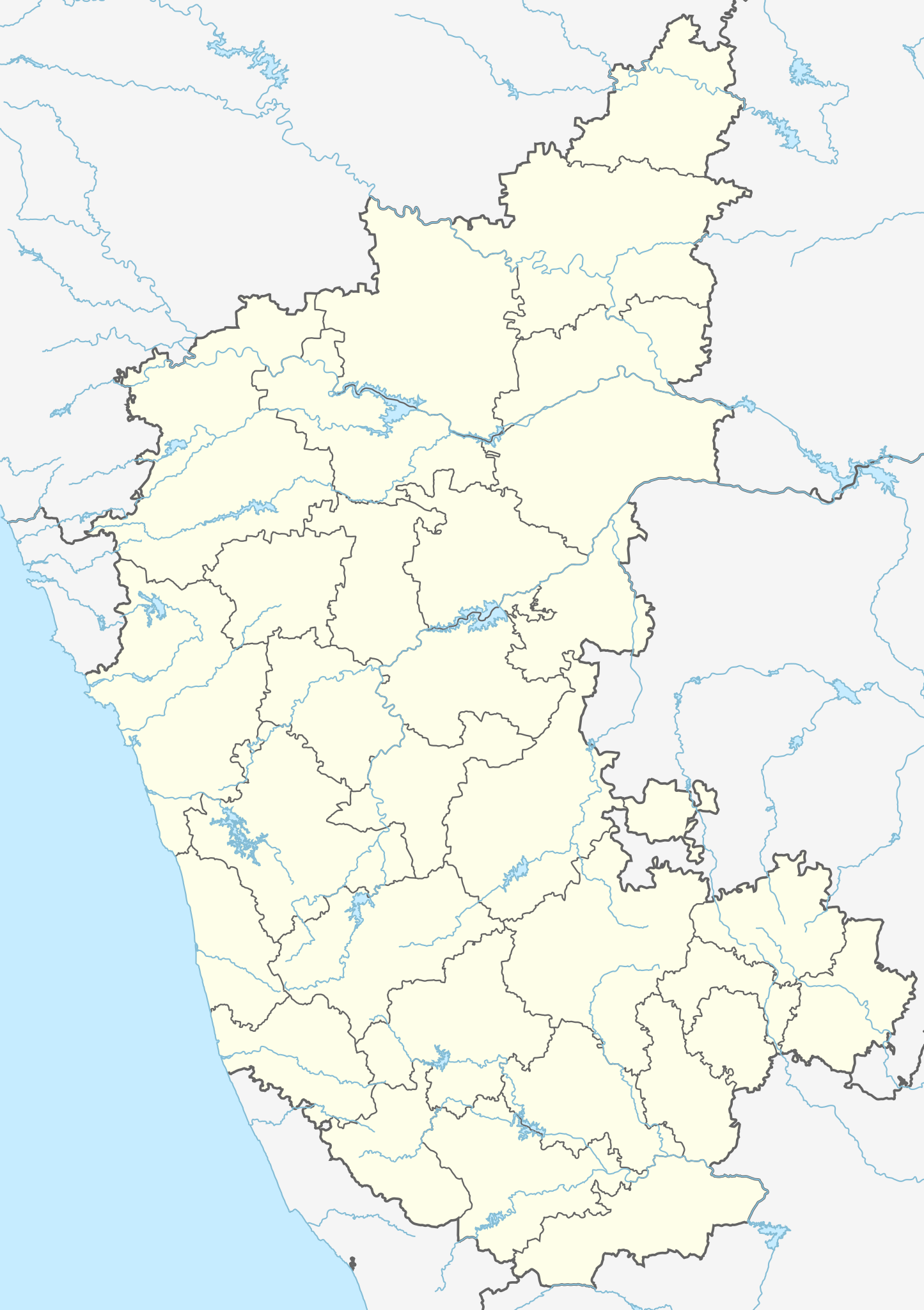
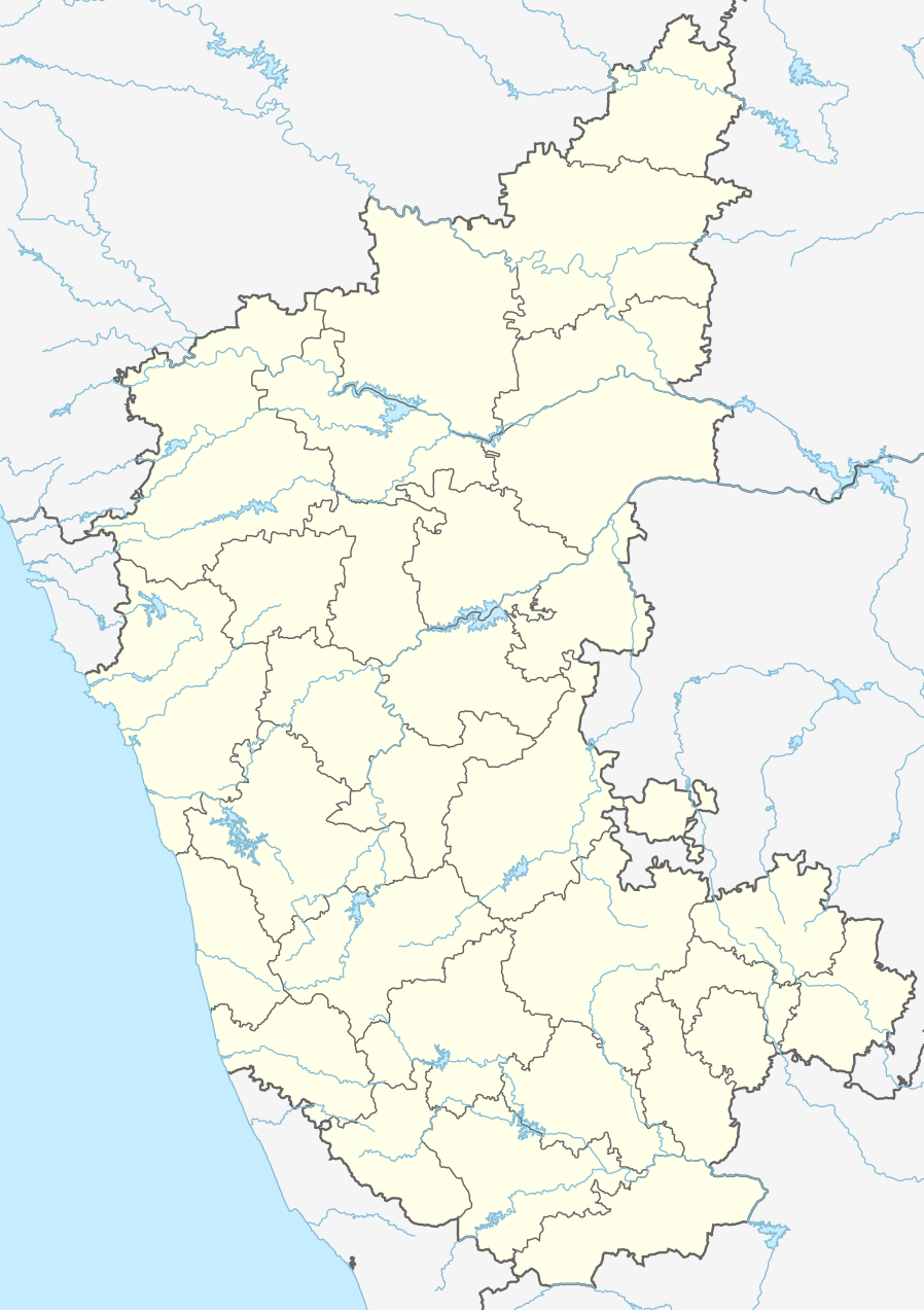
Location map of Karnataka Geographic limits of the map:
|
| 日期 | (UTC) |
| 來源 | |
| 作者 |
|
| 其他版本 |
此檔案衍生的作品: |
| 這是一張修飾過的圖片,即本圖片是用軟體修改過後的版本,修改的方式或內容有:Created 3 new districts Chikkaballapur, Ramanagara and Yadgir. Changed conventions per WP:WPMAP。原版圖片來源:Karnataka locator map.svg。修改者:Nayvik。
|
此檔案採用創用CC 姓名標示-相同方式分享 3.0 未在地化版本授權條款。
- 您可以自由:
- 分享 – 複製、發佈和傳播本作品
- 重新修改 – 創作演繹作品
- 惟需遵照下列條件:
- 姓名標示 – 您必須指名出正確的製作者,和提供授權條款的連結,以及表示是否有對內容上做出變更。您可以用任何合理的方式來行動,但不得以任何方式表明授權條款是對您許可或是由您所使用。
- 相同方式分享 – 如果您利用本素材進行再混合、轉換或創作,您必須基於如同原先的相同或兼容的條款,來分布您的貢獻成品。
原始上傳日誌
[編輯]
This image is a derivative work of the following images:
- File:Karnataka_locator_map.svg licensed with Cc-by-sa-3.0
- 2007-05-06T13:55:02Z Planemad 1630x2356 (231773 Bytes) {{WikiProject_India_Maps |Title=Karnataka locator Map |Description=Map of [[w:Karnataka]] with road and rail lines |Source= [http://aquarium.lipetsk.ru/discovery/India2004/karnataka-map.jpg Karnataka Map], [http://www.indianr
Uploaded with derivativeFX
檔案歷史
點選日期/時間以檢視該時間的檔案版本。
| 日期/時間 | 縮圖 | 尺寸 | 使用者 | 備註 | |
|---|---|---|---|---|---|
| 目前 | 2023年6月16日 (五) 03:10 | | 898 × 1,273(759 KB) | C1MM(留言 | 貢獻) | c Vijayanagara district |
| 2021年8月13日 (五) 04:41 |  | 851 × 1,211(582 KB) | C1MM(留言 | 貢獻) | Added more rivers | |
| 2021年7月16日 (五) 03:33 |  | 851 × 1,211(561 KB) | C1MM(留言 | 貢獻) | Added more accurate district boundaries | |
| 2020年12月14日 (一) 23:41 |  | 1,634 × 2,367(341 KB) | C1MM(留言 | 貢獻) | Fixed boundaries of Vijayanagara district | |
| 2020年12月14日 (一) 22:10 |  | 1,634 × 2,367(345 KB) | C1MM(留言 | 貢獻) | Added boundaries of AP/Telangana and rivers | |
| 2020年12月13日 (日) 19:26 |  | 1,634 × 2,367(342 KB) | C1MM(留言 | 貢獻) | Fixed district boundaries of Ballari and added Vijayanagara district | |
| 2020年4月21日 (二) 03:53 |  | 1,634 × 2,367(289 KB) | C1MM(留言 | 貢獻) | Added rivers | |
| 2010年11月15日 (一) 15:50 |  | 1,630 × 2,356(207 KB) | Nayvik(留言 | 貢獻) | Changed background color | |
| 2010年11月15日 (一) 15:34 |  | 1,630 × 2,356(206 KB) | Nayvik(留言 | 貢獻) | {{Information |Description=Location map of Karnataka Geographic limits of the map: * 18.5°N * 11.0°N * 73.6°E * 78.7°E |Source=*File:Karnataka_locator_map.svg, [http://www.censusindia.gov.in/2011-Images/ADMINI2011.jpg Census In |
無法覆蓋此檔案。
檔案用途
下列77個頁面有用到此檔案:
- ಕರ್ನಾಟಕ
- File:Districts affected by Sept 2008 Hindu-Christian conflict.svg
- File:India Karnataka COVID-19 map.png
- File:India Karnataka COVID-19 map.svg
- File:Karnataka Bangalore Rural locator map.svg
- File:Karnataka Bangalore Urban locator map.svg
- File:Karnataka Belgaum locator map.svg
- File:Karnataka Bellary locator map.svg
- File:Karnataka Bidar locator map.svg
- File:Karnataka Bijapur locator map.svg
- File:Karnataka Chamarajanagar locator map.svg
- File:Karnataka Chikballapur locator map.svg
- File:Karnataka Chikmagalur locator map.svg
- File:Karnataka Chitradurga locator map.svg
- File:Karnataka DK locator map.svg
- File:Karnataka Davanagere locator map.svg
- File:Karnataka Dharwad locator map.svg
- File:Karnataka Gadag locator map.svg
- File:Karnataka Gulbarga locator map.svg
- File:Karnataka Hassan locator.svg
- File:Karnataka Haveri locator map.svg
- File:Karnataka Kodagu locator map.svg
- File:Karnataka Kolar locator map.svg
- File:Karnataka Koppal locator map.svg
- File:Karnataka Mandya locator map.svg
- File:Karnataka Mysore locator map.svg
- File:Karnataka Raichur locator map.svg
- File:Karnataka Ramanagara locator map.svg
- File:Karnataka Shimoga locator map.svg
- File:Karnataka State Highway 5.svg
- File:Karnataka Tumkur locator map.svg
- File:Karnataka UK locator map.svg
- File:Karnataka Udupi locator map.svg
- File:Karnataka Yadgir locator map.svg
- File:Karnataka divisions.svg
- Category:Airports in Karnataka
- Category:Archaeological sites in Karnataka
- Category:Bodies of water in Karnataka
- Category:Bridges in Karnataka
- Category:Buddhism in Karnataka
- Category:Buddhist temples in Karnataka
- Category:Bus stations in Karnataka
- Category:Dams in Karnataka
- Category:Deaths in Karnataka
- Category:Disasters and accidents in Karnataka
- Category:Engineers from Karnataka
- Category:Festivals of Karnataka
- Category:Film directors from Karnataka
- Category:Flora of Karnataka
- Category:Forts in Karnataka
- Category:Hill stations in Karnataka
- Category:Hills of Karnataka
- Category:Hindu temples in Karnataka
- Category:Hospitals in Karnataka
- Category:Jain temples in Karnataka
- Category:Karnataka
- Category:Lakes of Karnataka
- Category:Maps of Karnataka
- Category:Mountains of Karnataka
- Category:Municipal corporations in Karnataka
- Category:Museums in Karnataka
- Category:Newspapers of Karnataka
- Category:Palaces in Karnataka
- Category:Populated places in Karnataka
- Category:Postcards of Karnataka
- Category:Power plants in Karnataka
- Category:Rail transport in Karnataka
- Category:Railway junction stations in Karnataka
- Category:Railway stations in Karnataka
- Category:Reservoirs in Karnataka
- Category:Rivers of Karnataka
- Category:Roads in Karnataka
- Category:Screenwriters from Karnataka
- Category:Shiva temples in Karnataka
- Category:Temples in Karnataka
- Category:Visitor attractions in Karnataka
- Category:Waterfalls in Karnataka
全域檔案使用狀況
以下其他 wiki 使用了這個檔案:
- ar.wikipedia.org 的使用狀況
- as.wikipedia.org 的使用狀況
- azb.wikipedia.org 的使用狀況
- تومکور
- بنقلور
- عباسی، کارناتاکا
- اودقولام
- پیکلیهال
- اوداجی (هیندوستان)
- اوچیلا, اودوپی دیستریکت
- اوچاواد
- او خاناپور
- ویراهانوماکاناپالیا
- فاجیر (هیندوستان)
- پتالور (هیندوستان)
- پت آماپور
- ویراکامبا
- ویراپور
- وانور (هیندوستان)
- ساتیجری
- ساتانور, ماقادی
- ساتانور, بانقالور
- ساسالاتی
- سارقور
- ساراواد
- ساراپادی
- ساپتاساقار
- سانتور
- سانتکاسالاجر
- مایاکوندا
- ساناتی
- ماویناکر
- ماوالی
- ماتیواد
- کالادکا
- سانیکاتا
- کالکونت
- کالکری
- ماتماری
- سانقاناهالا
- کالجی (هیندوستان)
- سانقامشوارا, کالاقاتاجی
- ماتاداکوروباراهاتی
- ماستیهولی
- کالاسا, کوندقول
- ماسارکال
- ماسابینال
- سامس (هیندوستان)
- سامپیج
- سامپاج
檢視此檔案的更多全域使用狀況。