File:India Karnataka location map.svg
跳转到导航
跳转到搜索

此SVG文件的PNG预览的大小:423 × 600像素。 其他分辨率:169 × 240像素 | 338 × 480像素 | 542 × 768像素 | 722 × 1,024像素 | 1,445 × 2,048像素 | 898 × 1,273像素。
原始文件 (SVG文件,尺寸为898 × 1,273像素,文件大小:759 KB)
说明
说明
添加一行文字以描述该文件所表现的内容
| 描述 |
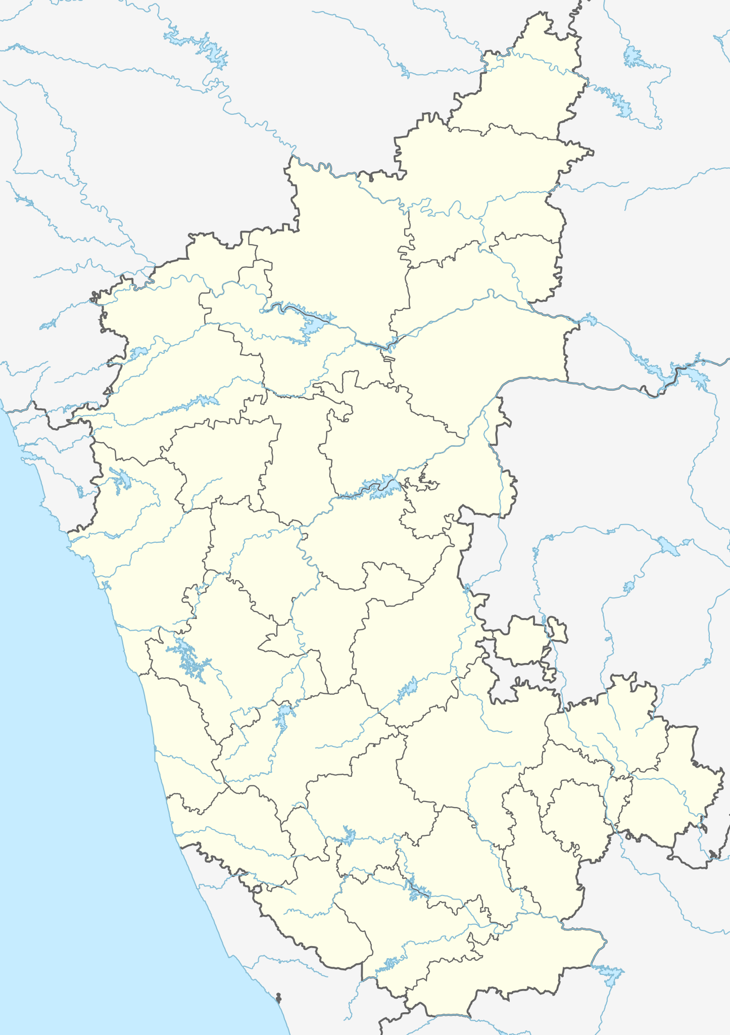
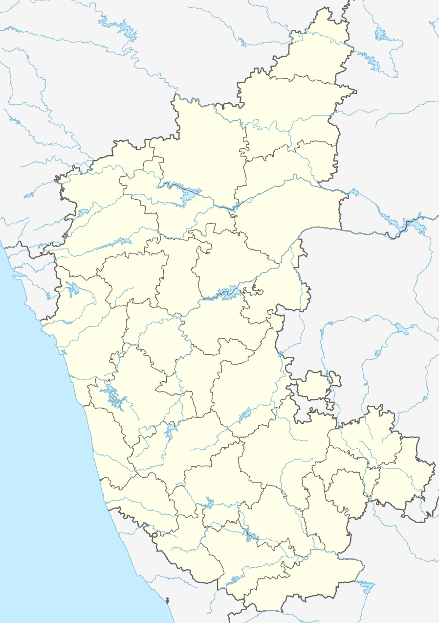
Location map of Karnataka Geographic limits of the map:
|
| 日期 | (UTC) |
| 来源 | |
| 作者 |
|
| 其他版本 |
Derivative works of this file: |
| 这是一张修改过的图片,这意味着它已在原版本的基础上通过软件进行了编辑,改动内容:Created 3 new districts Chikkaballapur, Ramanagara and Yadgir. Changed conventions per WP:WPMAP。其原始版本为:Karnataka locator map.svg。修改者:Nayvik。
|
本文件采用知识共享署名-相同方式共享 3.0 未本地化版本许可协议授权。
- 您可以自由地:
- 共享 – 复制、发行并传播本作品
- 修改 – 改编作品
- 惟须遵守下列条件:
- 署名 – 您必须对作品进行署名,提供授权条款的链接,并说明是否对原始内容进行了更改。您可以用任何合理的方式来署名,但不得以任何方式表明许可人认可您或您的使用。
- 相同方式共享 – 如果您再混合、转换或者基于本作品进行创作,您必须以与原先许可协议相同或相兼容的许可协议分发您贡献的作品。
原始上传日志
[编辑]
This image is a derivative work of the following images:
- File:Karnataka_locator_map.svg licensed with Cc-by-sa-3.0
- 2007-05-06T13:55:02Z Planemad 1630x2356 (231773 Bytes) {{WikiProject_India_Maps |Title=Karnataka locator Map |Description=Map of [[w:Karnataka]] with road and rail lines |Source= [http://aquarium.lipetsk.ru/discovery/India2004/karnataka-map.jpg Karnataka Map], [http://www.indianr
Uploaded with derivativeFX
文件历史
点击某个日期/时间查看对应时刻的文件。
| 日期/时间 | 缩略图 | 大小 | 用户 | 备注 | |
|---|---|---|---|---|---|
| 当前 | 2023年6月16日 (五) 03:10 | | 898 × 1,273(759 KB) | C1MM(留言 | 贡献) | c Vijayanagara district |
| 2021年8月13日 (五) 04:41 |  | 851 × 1,211(582 KB) | C1MM(留言 | 贡献) | Added more rivers | |
| 2021年7月16日 (五) 03:33 |  | 851 × 1,211(561 KB) | C1MM(留言 | 贡献) | Added more accurate district boundaries | |
| 2020年12月14日 (一) 23:41 |  | 1,634 × 2,367(341 KB) | C1MM(留言 | 贡献) | Fixed boundaries of Vijayanagara district | |
| 2020年12月14日 (一) 22:10 |  | 1,634 × 2,367(345 KB) | C1MM(留言 | 贡献) | Added boundaries of AP/Telangana and rivers | |
| 2020年12月13日 (日) 19:26 |  | 1,634 × 2,367(342 KB) | C1MM(留言 | 贡献) | Fixed district boundaries of Ballari and added Vijayanagara district | |
| 2020年4月21日 (二) 03:53 |  | 1,634 × 2,367(289 KB) | C1MM(留言 | 贡献) | Added rivers | |
| 2010年11月15日 (一) 15:50 |  | 1,630 × 2,356(207 KB) | Nayvik(留言 | 贡献) | Changed background color | |
| 2010年11月15日 (一) 15:34 |  | 1,630 × 2,356(206 KB) | Nayvik(留言 | 贡献) | {{Information |Description=Location map of Karnataka Geographic limits of the map: * 18.5°N * 11.0°N * 73.6°E * 78.7°E |Source=*File:Karnataka_locator_map.svg, [http://www.censusindia.gov.in/2011-Images/ADMINI2011.jpg Census In |
您不可以覆盖此文件。
文件用途
以下77个页面使用本文件:
- Karnataka
- File:Districts affected by Sept 2008 Hindu-Christian conflict.svg
- File:India Karnataka COVID-19 map.png
- File:India Karnataka COVID-19 map.svg
- File:Karnataka Bangalore Rural locator map.svg
- File:Karnataka Bangalore Urban locator map.svg
- File:Karnataka Belgaum locator map.svg
- File:Karnataka Bellary locator map.svg
- File:Karnataka Bidar locator map.svg
- File:Karnataka Bijapur locator map.svg
- File:Karnataka Chamarajanagar locator map.svg
- File:Karnataka Chikballapur locator map.svg
- File:Karnataka Chikmagalur locator map.svg
- File:Karnataka Chitradurga locator map.svg
- File:Karnataka DK locator map.svg
- File:Karnataka Davanagere locator map.svg
- File:Karnataka Dharwad locator map.svg
- File:Karnataka Gadag locator map.svg
- File:Karnataka Gulbarga locator map.svg
- File:Karnataka Hassan locator.svg
- File:Karnataka Haveri locator map.svg
- File:Karnataka Kodagu locator map.svg
- File:Karnataka Kolar locator map.svg
- File:Karnataka Koppal locator map.svg
- File:Karnataka Mandya locator map.svg
- File:Karnataka Mysore locator map.svg
- File:Karnataka Raichur locator map.svg
- File:Karnataka Ramanagara locator map.svg
- File:Karnataka Shimoga locator map.svg
- File:Karnataka State Highway 5.svg
- File:Karnataka Tumkur locator map.svg
- File:Karnataka UK locator map.svg
- File:Karnataka Udupi locator map.svg
- File:Karnataka Yadgir locator map.svg
- File:Karnataka divisions.svg
- Category:Airports in Karnataka
- Category:Archaeological sites in Karnataka
- Category:Bodies of water in Karnataka
- Category:Bridges in Karnataka
- Category:Buddhism in Karnataka
- Category:Buddhist temples in Karnataka
- Category:Bus stations in Karnataka
- Category:Dams in Karnataka
- Category:Deaths in Karnataka
- Category:Disasters and accidents in Karnataka
- Category:Engineers from Karnataka
- Category:Festivals of Karnataka
- Category:Film directors from Karnataka
- Category:Flora of Karnataka
- Category:Forts in Karnataka
- Category:Hill stations in Karnataka
- Category:Hills of Karnataka
- Category:Hindu temples in Karnataka
- Category:Hospitals in Karnataka
- Category:Jain temples in Karnataka
- Category:Karnataka
- Category:Lakes of Karnataka
- Category:Maps of Karnataka
- Category:Mountains of Karnataka
- Category:Municipal corporations in Karnataka
- Category:Museums in Karnataka
- Category:Newspapers of Karnataka
- Category:Palaces in Karnataka
- Category:Populated places in Karnataka
- Category:Postcards of Karnataka
- Category:Power plants in Karnataka
- Category:Rail transport in Karnataka
- Category:Railway junction stations in Karnataka
- Category:Railway stations in Karnataka
- Category:Reservoirs in Karnataka
- Category:Rivers of Karnataka
- Category:Roads in Karnataka
- Category:Screenwriters from Karnataka
- Category:Shiva temples in Karnataka
- Category:Temples in Karnataka
- Category:Visitor attractions in Karnataka
- Category:Waterfalls in Karnataka
全域文件用途
以下其他wiki使用此文件:
- ar.wikipedia.org上的用途
- as.wikipedia.org上的用途
- azb.wikipedia.org上的用途
- تومکور
- بنقلور
- عباسی، کارناتاکا
- اودقولام
- پیکلیهال
- اوداجی (هیندوستان)
- اوچیلا, اودوپی دیستریکت
- اوچاواد
- او خاناپور
- ویراهانوماکاناپالیا
- فاجیر (هیندوستان)
- پتالور (هیندوستان)
- پت آماپور
- ویراکامبا
- ویراپور
- وانور (هیندوستان)
- ساتیجری
- ساتانور, ماقادی
- ساتانور, بانقالور
- ساسالاتی
- سارقور
- ساراواد
- ساراپادی
- ساپتاساقار
- سانتور
- سانتکاسالاجر
- مایاکوندا
- ساناتی
- ماویناکر
- ماوالی
- ماتیواد
- کالادکا
- سانیکاتا
- کالکونت
- کالکری
- ماتماری
- سانقاناهالا
- کالجی (هیندوستان)
- سانقامشوارا, کالاقاتاجی
- ماتاداکوروباراهاتی
- ماستیهولی
- کالاسا, کوندقول
- ماسارکال
- ماسابینال
查看此文件的更多全域用途。