File:India disputed areas map.svg

原始文件 (SVG文件,尺寸为1,639 × 1,852像素,文件大小:978 KB)
说明
说明
摘要
[编辑]
| 标题 |
India map disputed areas |
| 描写 |
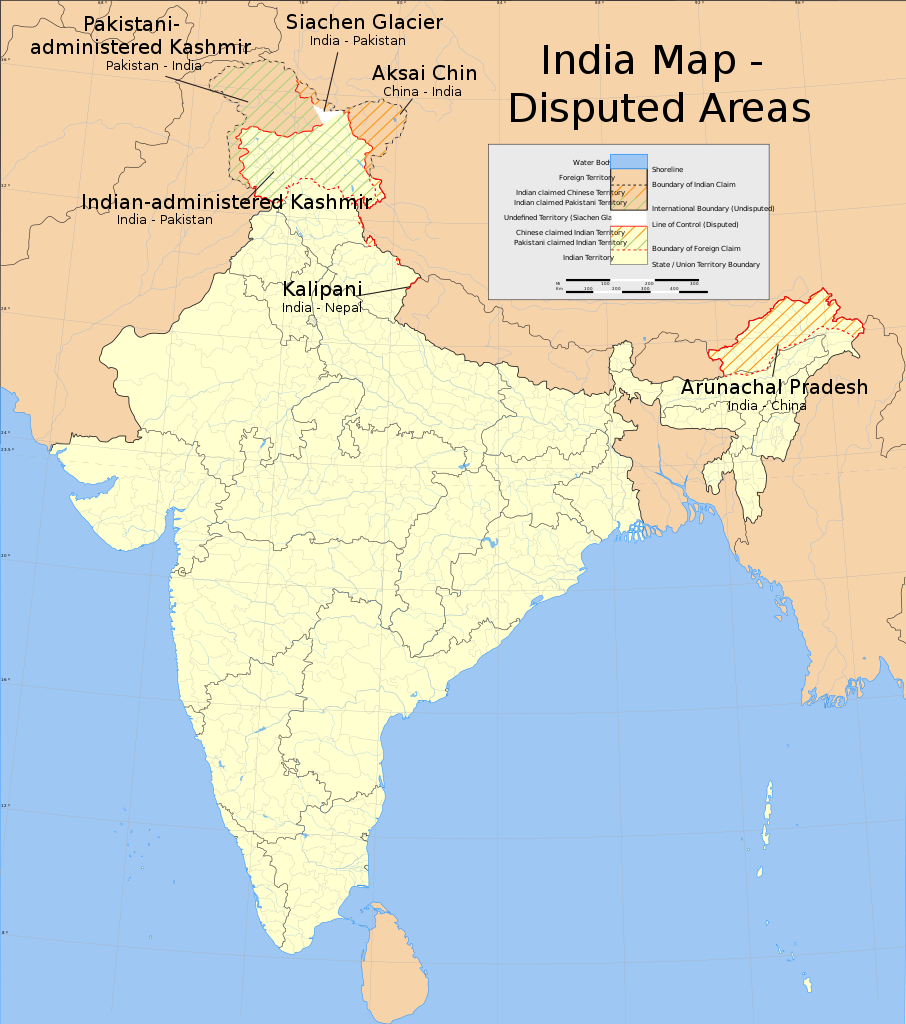
English: Map showing disputed areas of India. See also File:India Pakistan China Disputed Areas Map.png. |
| 地图图例 |
 |
| 日期 | |
| 来源 |
自己的作品 |
| 创作作者 | |
| 授权 (二次使用本文件) |
|
| Geotemporal data | |
| 描绘日期 | 20世纪下半期和21世纪 |
| 空间参照系统 | conic |
| 地理参考 | 如果不适当,请设置 warp_status = skip 为隐藏。 |
| Archival data | |
| 备注 | Part of WikiProject India Maps |
| SVG开发 | 本W3C无效的矢量图使用Adobe Illustrator创作。 |
Notes
[编辑]Depiction of India's borders
[编辑]- The territorial boundaries of India are shown as per the actual ground situation in accordance with international practices followed by the United Nations ([1], [2]) and the National Geographic Society ([3], [4])
- This map is meant to be for illustrative purpose only and is not authenticated by official government sources. Please check the list of sources and references used to create the map for a measure of accuracy and verifiability.
- The usage of these maps in India, Pakistan and China are governed by different laws that restrict depictions of boundaries other than what is officially recognized by the state. Please check local laws and modify the map accordingly before use.
Explanation of disputed boundaries
[编辑]

- Boundary of Indian claim : The territory India claims is legally theirs, but the claim is disputed by China and Pakistan.
- Line of Control/Line of Conflict : The de facto administrative boundary recognised by the international community. This UN ceasefire line is considered as a temporary solution to an ongoing conflict since the departure of the British Raj.
Borders of disputed regions
[编辑]The depicted extent of the former territory of the British Indian Empire, succeeded by Republic of India, may not be accepted by few countries as legal due to ongoing border disputes:
- The northern Himalayan region of the disputed territory Indian-administered Kashmir is claimed by India including (Pakistan-administered Kashmir) and the Chinese-occupied territory of (Ladakh plateau). Since 1972, it is divided between all three countries. See also Line of Control and Line of Actual Control.
- Siachen glacier (shown white) is an actively contested region between India and Pakistan. Since 1984, the region is under Indian control.
- The northeastern territory of Arunachal Pradesh is almost entirely claimed by China as part of its Tibetan territory.
- Minor areas of eastern Kashmir's Ladakh division, Himachal Pradesh and Uttarakhand on the Chinese frontier are claimed by China. These areas are under Indian control.
- A small area of Uttarakhand adjoining the Nepal border along the Sarda river is disputed between the two countries.
For a detailed map of all disputed regions in South Asia, see Image:India disputed areas map.svg
Internal borders
[编辑]The borders of the state of Meghalaya, Assam and Arunachal Pradesh are shown as interpreted from the North-Eastern Areas (Reorganisation) Act, 1971, but has yet to be verified.
Territorial waters
[编辑]The limit of the territorial waters of India extends to twelve nautical miles measured from the appropriate baseline. See this for more information.
许可协议
[编辑]
- 您可以自由地:
- 共享 – 复制、发行并传播本作品
- 修改 – 改编作品
- 惟须遵守下列条件:
- 署名 – 您必须对作品进行署名,提供授权条款的链接,并说明是否对原始内容进行了更改。您可以用任何合理的方式来署名,但不得以任何方式表明许可人认可您或您的使用。
- 相同方式共享 – 如果您再混合、转换或者基于本作品进行创作,您必须以与原先许可协议相同或相兼容的许可协议分发您贡献的作品。
文件历史
点击某个日期/时间查看对应时刻的文件。
| 日期/时间 | 缩略图 | 大小 | 用户 | 备注 | |
|---|---|---|---|---|---|
| 当前 | 2020年6月10日 (三) 11:51 | | 1,639 × 1,852(978 KB) | Uanfala(留言 | 贡献) | Quickly change the wording in Kashmir for neutrality and consistency |
| 2006年7月31日 (一) 12:55 |  | 1,639 × 1,852(978 KB) | Planemad(留言 | 贡献) | {{WikiProject_India_Maps |Title=India map disputed areas |Description=Map showing disputed areas of India. |Source=. |Date=July 31 2006 |Author=w:user:Planemad |Thumbdir=a/ab }} |
您不可以覆盖此文件。
文件用途
超过100个页面使用本文件。 下面的列表只显示使用本文件的前100个页面。完整列表可用。
- Atlas of India
- File:India Andhra Pradesh locator map (1956-2014).svg
- File:India Arunachal Pradesh locator map.svg
- File:India Assam locator map.svg
- File:India Awadh locator map.svg
- File:India Bagelkhand locator map.svg
- File:India Bihar locator map.svg
- File:India Bundelkhand locator map.svg
- File:India Carnatic locator map.svg
- File:India Central Travancore locator map.svg
- File:India Chhattisgarh locator map.svg
- File:India Chola Nadu locator map.svg
- File:India Circar locator map.svg
- File:India Coastal Andhra locator map.svg
- File:India Coromandel Coast locator map.svg
- File:India Delhi locator map.svg
- File:India Dhundhar locator map.svg
- File:India Goa locator map.svg
- File:India Godwar locator map.svg
- File:India Gujarat locator map.svg
- File:India Hadoti locator map.svg
- File:India Harit Pradesh locator map.svg
- File:India Haryana locator map.svg
- File:India Himachal Pradesh locator map.svg
- File:India Jammu and Kashmir locator map.svg
- File:India Jharkhand locator map.svg
- File:India Karnataka locator map.svg
- File:India Kerala locator map.svg
- File:India Khandesh locator map.svg
- File:India Kongu Nadu locator map.svg
- File:India Konkan locator map.svg
- File:India Kutch locator map.svg
- File:India Lakshadweep locator map.svg
- File:India Madhya Pradesh locator map.svg
- File:India Maharashtra locator map.svg
- File:India Malabar Coast locator map.svg
- File:India Malabar locator map.svg
- File:India Manipur locator map.svg
- File:India Marathwada locator map.svg
- File:India Marwar locator map.svg
- File:India Meghalaya locator map.svg
- File:India Mewar locator map.svg
- File:India Mewat locator map.svg
- File:India Mizoram locator map.svg
- File:India Nagaland locator map.svg
- File:India Naxal affected districts map.svg
- File:India Orissa locator map.svg
- File:India Pandya Nadu locator map.svg
- File:India Punjab locator map.svg
- File:India Purvanchal locator map.svg
- File:India Rajasthan locator map.svg
- File:India Rayalaseema locator map.svg
- File:India Saurashtra locator map.svg
- File:India Shekhawati locator map.svg
- File:India Sikkim locator map.svg
- File:India Tamil Nadu locator map.svg
- File:India Telangana locator map.svg
- File:India Thar locator map.svg
- File:India Travancore locator map.svg
- File:India Tripura locator map.svg
- File:India Uttar Pradesh locator map.svg
- File:India Uttarakhand locator map.svg
- File:India Uttaranchal locator map.svg
- File:India Vagad locator map.svg
- File:India Venad locator map.svg
- File:India Vidarbha locator map.svg
- File:India West Bengal locator map.svg
- File:India annual rainfall map.svg
- File:India annual rainfall map en.svg
- File:India average annual temperature map en.svg
- File:India climatic disaster risk map en.svg
- File:India climatic zone map en.svg
- File:India decadal growth rate map.svg
- File:India decadal growth rate map en.svg
- File:India disputed areas map.svg
- File:India earthquake zone map.svg
- File:India earthquake zone map en.svg
- File:India flood zone map.svg
- File:India literacy rate map.svg
- File:India literacy rate map en.svg
- File:India map blank.svg
- File:India map en.svg
- File:India physical map.svg
- File:India population density map.svg
- File:India population density map en.svg
- File:India rivers and lakes map.svg
- File:India roadway map.svg
- File:India roadway map with population density.svg
- File:India sex ratio map.svg
- File:India sex ratio map en.svg
- File:India simplified roadway map.svg
- File:India southwest summer monsoon onset map en.svg
- File:India states and union territories map.svg
- File:India states and union territories numbered map.svg
- File:India topographical roadway map.svg
- File:India wind zone map.svg
- File:India wind zone map en.svg
- File:Indian Kadamba Empire map.svg
- File:Indian Kanauj triangle map.svg
- File:Indian Mysore Kingdom 1784 map.svg
.svg)
查看连接到这个文件的更多链接。
全域文件用途
以下其他wiki使用此文件:
- en.wikipedia.org上的用途
- es.wikipedia.org上的用途
- fi.wikipedia.org上的用途
- fr.wikipedia.org上的用途
- ja.wikipedia.org上的用途
- kn.wikipedia.org上的用途
- ml.wikipedia.org上的用途
- mr.wikipedia.org上的用途
- or.wikipedia.org上的用途
- pa.wikipedia.org上的用途
- pnb.wikipedia.org上的用途
- ru.wikinews.org上的用途
- sh.wikipedia.org上的用途
- sr.wikipedia.org上的用途
- sv.wikipedia.org上的用途
- ta.wikipedia.org上的用途
- te.wikipedia.org上的用途
- ur.wikipedia.org上的用途
- vi.wikipedia.org上的用途
- www.wikidata.org上的用途
- zh.wikipedia.org上的用途