File:India physical map.svg

Archivo original (archivo SVG, nominalmente 1639 × 1852 píxeles, tamaño de archivo: 884 kB)
Leyendas
Leyendas
| Título |
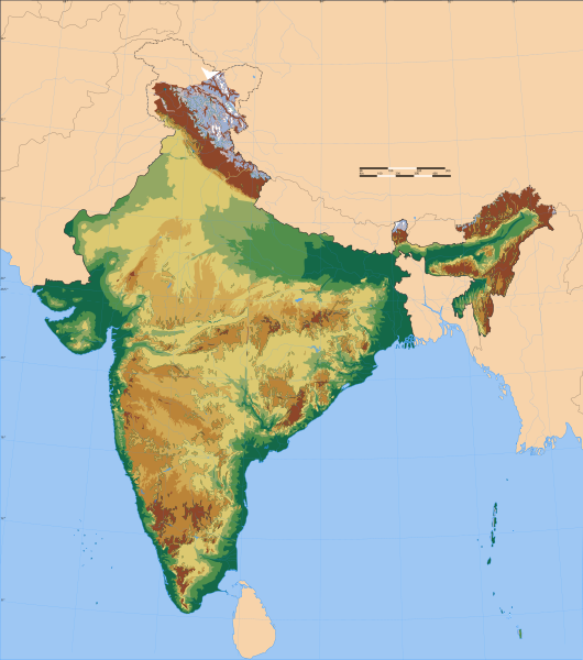
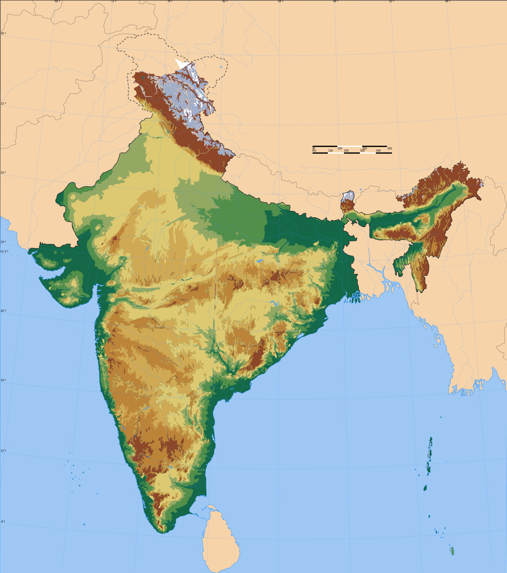
India physical map |
|||||||||
| Descripción |
Physical map of territory claimed by India |
|||||||||
| Map legend |
 |
|||||||||
| Fecha | ||||||||||
| Fuente |
Trabajo propio |
|||||||||
| Creador | ||||||||||
| Permiso (Reutilización de este archivo) |
Yo, el titular de los derechos de autor de esta obra, la publico en los términos de la siguiente licencia: Este archivo se encuentra bajo la licencia Creative Commons Genérica de Atribución/Compartir-Igual 3.0.
|
|||||||||
| Geotemporal data | ||||||||||
| Fecha representada | segunda mitad de siglo XX y siglo XXI | |||||||||
| Sistema de referencia espacial | conic | |||||||||
| Bounding box |
|
|||||||||
| Georeferencing | If inappropriate please set warp_status = skip to hide. | |||||||||
| Archival data | ||||||||||
| Notas | Part of WikiProject India Maps | |||||||||

Notes[editar]
Depiction of India's borders[editar]
- The territorial boundaries of India are shown as per the actual ground situation in accordance with international practices followed by the United Nations ([1], [2]) and the National Geographic Society ([3], [4])
- This map is meant to be for illustrative purpose only and is not authenticated by official government sources. Please check the list of sources and references used to create the map for a measure of accuracy and verifiability.
- The usage of these maps in India, Pakistan and China are governed by different laws that restrict depictions of boundaries other than what is officially recognized by the state. Please check local laws and modify the map accordingly before use.
Explanation of disputed boundaries[editar]


- Boundary of Indian claim : The territory India claims is legally theirs, but the claim is disputed by China and Pakistan.
- Line of Control/Line of Conflict : The de facto administrative boundary recognised by the international community. This UN ceasefire line is considered as a temporary solution to an ongoing conflict since the departure of the British Raj.
Borders of disputed regions[editar]
The depicted extent of the former territory of the British Indian Empire, succeeded by Republic of India, may not be accepted by few countries as legal due to ongoing border disputes:
- The northern Himalayan region of the disputed territory Indian-administered Kashmir is claimed by India including (Pakistan-administered Kashmir) and the Chinese-occupied territory of (Ladakh plateau). Since 1972, it is divided between all three countries. See also Line of Control and Line of Actual Control.
- Siachen glacier (shown white) is an actively contested region between India and Pakistan. Since 1984, the region is under Indian control.
- The northeastern territory of Arunachal Pradesh is almost entirely claimed by China as part of its Tibetan territory.
- Minor areas of eastern Kashmir's Ladakh division, Himachal Pradesh and Uttarakhand on the Chinese frontier are claimed by China. These areas are under Indian control.
- A small area of Uttarakhand adjoining the Nepal border along the Sarda river is disputed between the two countries.
For a detailed map of all disputed regions in South Asia, see Image:India disputed areas map.svg
Internal borders[editar]
The borders of the state of Meghalaya, Assam and Arunachal Pradesh are shown as interpreted from the North-Eastern Areas (Reorganisation) Act, 1971, but has yet to be verified.
Territorial waters[editar]
The limit of the territorial waters of India extends to twelve nautical miles measured from the appropriate baseline. See this for more information.
derivative works[editar]
Obras derivadas de ésta: India physical map he.svg
Historial del archivo
Haz clic sobre una fecha y hora para ver el archivo tal como apareció en ese momento.
| Fecha y hora | Miniatura | Dimensiones | Usuario | Comentario | |
|---|---|---|---|---|---|
| actual | 23:39 12 ene 2014 | | 1639 × 1852 (884 kB) | AnonMoos (discusión | contribs.) | remove Adobe cruft |
| 07:57 11 sep 2006 |  | 1639 × 1852 (922 kB) | Planemad (discusión | contribs.) | {{WikiProject_India_Maps |Title=India physical map |Description=Physical map of India |Source=. |Date=September 2006 |Author=w:user:Planemad |Thumbdir=CHANGE }} |
No puedes sobrescribir este archivo.
Usos del archivo
Las siguientes páginas usan este archivo:
Uso global del archivo
Las wikis siguientes utilizan este archivo:
- Uso en bg.wikipedia.org
- Uso en ca.wikipedia.org
- Uso en cs.wikipedia.org
- Uso en en.wikipedia.org
- Uso en eu.wikipedia.org
- Uso en fr.wikipedia.org
- Uso en he.wikipedia.org
- Uso en ja.wikipedia.org
- Uso en ku.wikipedia.org
- Uso en nl.wikipedia.org
- Uso en pl.wikipedia.org
- Uso en sq.wikipedia.org
- Uso en tg.wikipedia.org
- Uso en tum.wikipedia.org
- Uso en uk.wikipedia.org
- Обговорення:Бенгалуру
- Обговорення:Помста і закон
- Обговорення:Гоа
- Обговорення:Гіндукуш
- Обговорення:Каракорум
- Обговорення:Тхане
- Обговорення:Ассам
- Обговорення:Газіабад (місто)
- Обговорення:Музична кімната
- Обговорення:Гірська залізниця Нілґірі
- Обговорення:Дарджилінзька Гімалайська залізниця
- Обговорення:Залізниця Калка-Шімла
- Обговорення:Срініваса Рамануджан
- Обговорення:Ґгат
- Обговорення:Бутано-індійський кордон
- Обговорення:Громадянин (фільм)
- Обговорення:Ганді, мій батьку
- Обговорення:Дханбад
- Обговорення:Пакйонг
- Обговорення:Пудучеррі (місто)
- Обговорення:Махараштра
- Обговорення:Міста та містечка штату Махараштра
- Обговорення:Джаландхар
- Обговорення:Гваліор
- Обговорення:Атал Біхарі Ваджпаї
- Обговорення:Бодг-Ґая
- Обговорення:Гайдарабад (місто, Індія)
Ver más uso global de este archivo.