File:Indischer Ozean Beben2004.png
Jump to navigation
Jump to search

Size of this preview: 800 × 481 pixels. Other resolutions: 320 × 192 pixels | 640 × 385 pixels | 1,024 × 616 pixels | 1,500 × 902 pixels.
Original file (1,500 × 902 pixels, file size: 196 KB, MIME type: image/png)
Captions
Captions
Add a one-line explanation of what this file represents
Summary[edit]
| Description |
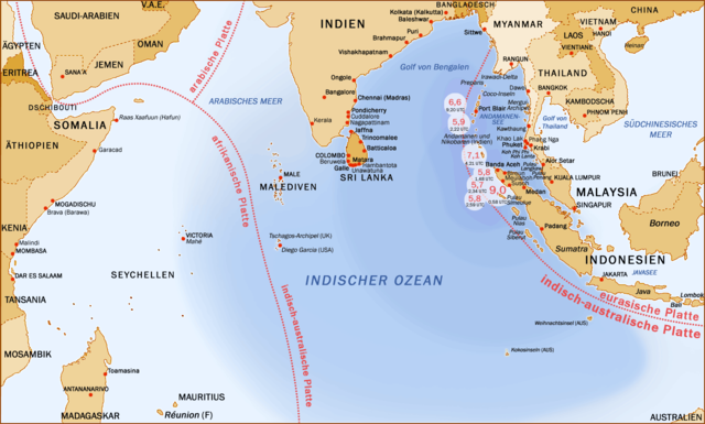
English: Earthquakes and aftershocks, Indian Ocean, 26.12.2009
Deutsch: Seebeben im Indischen Ozean am 26. Dezember 2004, Epizentren, schwere Nachbeben und betroffene Küsten.
Nederlands: Kaart van het gebied getroffen door de tsunami na zeebeving van 26 december 2004. |
| Date | 26 December 2004 (upload date) |
| Source | Transferred from de.wikipedia to Commons. |
| Author | Manfred Werner |
| Other versions |
 (translated, Dutch) |
Licensing[edit]

|
Permission is granted to copy, distribute and/or modify this document under the terms of the GNU Free Documentation License, Version 1.2 or any later version published by the Free Software Foundation; with no Invariant Sections, no Front-Cover Texts, and no Back-Cover Texts. A copy of the license is included in the section entitled GNU Free Documentation License. |
| This file is licensed under the Creative Commons Attribution-Share Alike 3.0 Unported license. | ||
| ||
| This licensing tag was added to this file as part of the GFDL licensing update. |
File history
Click on a date/time to view the file as it appeared at that time.
| Date/Time | Thumbnail | Dimensions | User | Comment | |
|---|---|---|---|---|---|
| current | 00:39, 1 January 2005 | | 1,500 × 902 (196 KB) | Tsui (talk | contribs) | updated |
| 22:19, 30 December 2004 |  | 1,500 × 902 (194 KB) | Tsui (talk | contribs) | updated (added other affected areas) | |
| 19:22, 29 December 2004 |  | 1,500 × 902 (192 KB) | Tsui (talk | contribs) | updated - aktualisiert | |
| 18:46, 28 December 2004 |  | 1,500 × 902 (189 KB) | Tsui (talk | contribs) | updated (aktualisierte Version: weitere betroffene Orte) | |
| 22:29, 27 December 2004 |  | 1,500 × 902 (176 KB) | Tsui (talk | contribs) | update | |
| 20:52, 27 December 2004 |  | 1,501 × 902 (173 KB) | Tsui (talk | contribs) | earthquake se-asia - updated map | |
| 04:36, 27 December 2004 |  | 1,293 × 861 (65 KB) | Dub (talk | contribs) | Edited. Strength of 8,9 changed into 9,0 | |
| 19:25, 26 December 2004 |  | 1,293 × 861 (77 KB) | Tsui (talk | contribs) | edited version (with aftershocks and UTC-times) | |
| 16:47, 26 December 2004 |  | 1,293 × 861 (83 KB) | Tsui (talk | contribs) | Earthquake Indian Ocean 26.12.2004 (Manfred Werner User:Tsui, GFDL,) |
You cannot overwrite this file.
File usage on Commons
The following 3 pages use this file:
File usage on other wikis
The following other wikis use this file:
- Usage on de.wikipedia.org
- Usage on de.wikinews.org
- Usage on de.wikiversity.org
- Usage on eo.wikipedia.org
- Usage on hu.wikipedia.org
- Usage on nn.wikipedia.org
- Usage on sv.wikipedia.org
- Usage on www.wikidata.org