File:Indo-European branches map.svg
跳至導覽
跳至搜尋

此 SVG 檔案的 PNG 預覽的大小:400 × 400 像素。 其他解析度:240 × 240 像素 | 480 × 480 像素 | 768 × 768 像素 | 1,024 × 1,024 像素 | 2,048 × 2,048 像素。
原始檔案 (SVG 檔案,表面大小:400 × 400 像素,檔案大小:749 KB)
說明
說明
添加單行說明來描述出檔案所代表的內容
摘要
[編輯]
| 描述 |
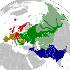
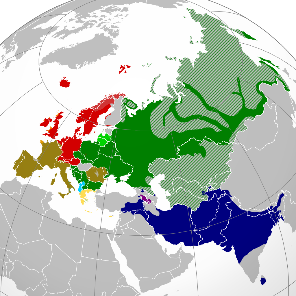
English: A map showing the approximate present-day distribution of the Indo-European branches within their homelands of Europe and Asia. The following legend is given in the chronological order of the earliest surviving written attestations of each branch:
Non-Indo-European languages
Dotted/striped areas indicate where multilingualism is common (more visible upon full enlargement of the map).Polski: Współczesne rozmieszczenie głównych gałęzi języków indoeuropejskich w Eurazji. Obszary kreskowane i kropkowane (lepiej widoczne w powiększeniu) oznaczają powszechną wielojęzyczność ich mieszkańców.
|
| 日期 | |
| 來源 |
English: Indo-European branches map.png
Polski: 我個人以下列物件為基礎來創作: Indo-European branches map.png 由 Hayden120; za: Approximate locations of Indo-European languages in contemporary Eurasia, Britannica Kids |
| 作者 |
English: Indo-European branches map.png: Hayden120
Polski: Alphathon |
.svg)
授權條款
[編輯]
我,本作品的著作權持有者,決定用以下授權條款發佈本作品:
此檔案採用創用CC 姓名標示-相同方式分享 3.0 未在地化版本授權條款。
- 您可以自由:
- 分享 – 複製、發佈和傳播本作品
- 重新修改 – 創作演繹作品
- 惟需遵照下列條件:
- 姓名標示 – 您必須指名出正確的製作者,和提供授權條款的連結,以及表示是否有對內容上做出變更。您可以用任何合理的方式來行動,但不得以任何方式表明授權條款是對您許可或是由您所使用。
- 相同方式分享 – 如果您利用本素材進行再混合、轉換或創作,您必須基於如同原先的相同或兼容的條款,來分布您的貢獻成品。

|
已授權您依據自由軟體基金會發行的無固定段落、封面文字和封底文字GNU自由文件授權條款1.2版或任意後續版本,對本檔進行複製、傳播和/或修改。該協議的副本列在GNU自由文件授權條款中。 |
您可以選擇您需要的授權條款。
檔案歷史
點選日期/時間以檢視該時間的檔案版本。
| 日期/時間 | 縮圖 | 尺寸 | 使用者 | 備註 | |
|---|---|---|---|---|---|
| 目前 | 2024年6月5日 (三) 16:20 | | 400 × 400(749 KB) | Golden(留言 | 貢獻) | update Karabakh |
| 2021年8月7日 (六) 17:12 |  | 400 × 400(749 KB) | Demetrios1993(留言 | 貢獻) | Reverted to version as of 12:41, 27 August 2016 (UTC) There seems to be an issue with my file, thus i am self-rv back to the previous version for the time being. | |
| 2021年8月7日 (六) 16:41 |  | 2,934 × 2,938(2.57 MB) | Demetrios1993(留言 | 貢獻) | Updated map; same as it is for the PNG version. | |
| 2016年8月27日 (六) 12:41 |  | 400 × 400(749 KB) | Rob984(留言 | 貢獻) | Georgia and Azerbaijan aren't majority multilingual any longer. Many, but not all, in older generations speak Russian from the Soviet era but now English is taught mainly in place of Russian. And we aren't showing Finland as multilingual in a Germanic... | |
| 2016年7月13日 (三) 05:44 |  | 400 × 400(753 KB) | Unghhg(留言 | 貢獻) | Reverted to version as of 03:51, 2 February 2016 (UTC) | |
| 2016年2月24日 (三) 14:50 |  | 400 × 400(755 KB) | Ercwlff(留言 | 貢獻) | for what reasons? | |
| 2016年2月2日 (二) 03:51 |  | 400 × 400(753 KB) | Turnless(留言 | 貢獻) | Reverted to version as of 17:01, 20 October 2015 (UTC) | |
| 2016年1月19日 (二) 17:10 |  | 400 × 400(755 KB) | Ercwlff(留言 | 貢獻) | fix Georgia | |
| 2015年10月20日 (二) 17:01 |  | 400 × 400(753 KB) | Alphathon(留言 | 貢獻) | Cropped | |
| 2015年10月20日 (二) 16:56 |  | 453 × 400(753 KB) | Alphathon(留言 | 貢獻) | {{Information |Description={{en|A map showing the approximate present-day distribution of the Indo-European branches within their homelands of Europe and Asia. The following legend is given in the chronological order of... |
無法覆蓋此檔案。
檔案用途
下列9個頁面有用到此檔案:
- User:Chumwa/OgreBot/Travel and communication maps/2016 August 21-31
- User:Chumwa/OgreBot/Travel and communication maps/2016 February 1-9
- User:Chumwa/OgreBot/Travel and communication maps/2016 February 20-29
- User:Chumwa/OgreBot/Travel and communication maps/2016 January 11-20
- User:Chumwa/OgreBot/Travel and communication maps/2016 July 11-20
- User:Chumwa/OgreBot/Travel and communication maps/2021 August 1-10
- User:Chumwa/OgreBot/Travel and communication maps/2024 June 1-10
- File:Indo-European branches map.png
- File:Indo-European steppe homeland map.svg
全域檔案使用狀況
以下其他 wiki 使用了這個檔案:
- af.wikipedia.org 的使用狀況
- am.wikipedia.org 的使用狀況
- ar.wikipedia.org 的使用狀況
- azb.wikipedia.org 的使用狀況
- az.wikipedia.org 的使用狀況
- bcl.wikipedia.org 的使用狀況
- bh.wikipedia.org 的使用狀況
- bn.wikipedia.org 的使用狀況
- bs.wikipedia.org 的使用狀況
- ca.wikipedia.org 的使用狀況
- ckb.wikipedia.org 的使用狀況
- cs.wikipedia.org 的使用狀況
- dty.wikipedia.org 的使用狀況
- en.wikipedia.org 的使用狀況
- Selonian language
- Semigallian language
- Bashkardi language
- List of Indo-European languages
- West Iberian languages
- Indogermanisches etymologisches Wörterbuch
- Aimaq dialect
- Alpha privative
- Southwestern Brittonic languages
- User:Irpen/sb
- Frahang-i Oim-evak
- Template:IndoEuropean-lang-stub
- Dzūkian dialect
- Encyclopedia of Indo-European Culture
- Grundriß der vergleichenden Grammatik der indogermanischen Sprachen
- *Kʷetwóres rule
- Digor Ossetian
- Iron Ossetian
- TITUS (project)
- Pisidian language
- Kamviri dialect
- Suri (flower)
- Sant Bhasha
- Tregami language
- Kalasha-ala
- Wasi-wari
- Borujerdi dialect
- Kamkata-vari language
- Mumviri dialect
- Vanji language
- Sivandi language
- Unified Cornish
- Semnani languages
- Sangsari language
檢視此檔案的更多全域使用狀況。