File:Indonesia, administrative divisions - pl - monochrome.svg
Jump to navigation
Jump to search

Size of this PNG preview of this SVG file: 800 × 367 pixels. Other resolutions: 320 × 147 pixels | 640 × 293 pixels | 1,024 × 469 pixels | 1,280 × 587 pixels | 2,560 × 1,173 pixels | 982 × 450 pixels.
Original file (SVG file, nominally 982 × 450 pixels, file size: 920 KB)
Captions
Captions
Add a one-line explanation of what this file represents
Summary[edit]
| Description |
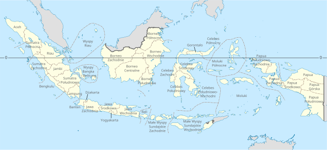
Polski: Prowincje Indonezji
English: Map of the provinces of Indonesia in Polish. |
| Date | |
| Source |
This file was derived from: Indonesia, administrative divisions - en - monochrome.svg: |
| Author |
This W3C-unspecified vector image was created with Inkscape . |
| Other versions |
|


Licensing[edit]
This file is licensed under the Creative Commons Attribution 3.0 Unported license.
- You are free:
- to share – to copy, distribute and transmit the work
- to remix – to adapt the work
- Under the following conditions:
- attribution – You must give appropriate credit, provide a link to the license, and indicate if changes were made. You may do so in any reasonable manner, but not in any way that suggests the licensor endorses you or your use.
File history
Click on a date/time to view the file as it appeared at that time.
| Date/Time | Thumbnail | Dimensions | User | Comment | |
|---|---|---|---|---|---|
| current | 19:16, 18 May 2023 | | 982 × 450 (920 KB) | SparrowhawkM (talk | contribs) | Uploaded a work by Sardon from *Indonesia, administrative divisions - en - monochrome.svg: *Indonesia, administrative divisions - mg - monochrome.svg: Sardon with UploadWizard |
You cannot overwrite this file.
File usage on Commons
The following 3 pages use this file:
File usage on other wikis
The following other wikis use this file:
- Usage on pl.wikipedia.org