File:Indus River and Manchhar Lake.jpg
পরিভ্রমণে চলুন
অনুসন্ধানে চলুন

এই প্রাকদর্শনের আকার: ১৯০ × ৫৯৯ পিক্সেল। অন্যান্য আকারসমূহ: ৭৬ × ২৪০ পিক্সেল | ১৫২ × ৪৮০ পিক্সেল | ২৪৩ × ৭৬৮ পিক্সেল | ৩২৪ × ১,০২৪ পিক্সেল | ২,৪০৭ × ৭,৫৯২ পিক্সেল।
মূল ফাইল (২,৪০৭ × ৭,৫৯২ পিক্সেল, ফাইলের আকার: ৩.২৩ মেগাবাইট, এমআইএমই ধরন: image/jpeg)
ক্যাপশনসমূহ
ক্যাপশন
এই ফাইল কি প্রতিনিধিত্ব করছে তার এক লাইন ব্যাখ্যা যোগ করুন
সারাংশ[সম্পাদনা]
| বিবরণ |
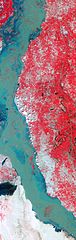
English: In this false-colour image, vegetation is red, and bare ground and settled areas vary in colour from gray to beige. Water ranges in colour from navy blue to teal. The greenish hue of the Indus River likely results from the flooded river’s heavy sediment load. Patches of red in the river hint at the scale of flooding; these areas are farmland submerged by the swollen Indus.
A network of canals connects the Indus to the nearby lake, which also appears flooded. Manchhar Lake (also spelled Manchar Lake) is Pakistan’s largest natural freshwater lake. Located immediately west of the city of Sehwan in the southern Pakistan province of Sindh, Manchhar Lake receives not only rainwater from a vast catchment area in western Sindh, but also fresh river water through the canals. Drainage water also feeds into Manchhar Lake through the Main Nara Valley Drain (not shown), which connects Manchhar to Hamal, another lake to the north. |
| তারিখ | |
| উৎস | NASA Earth Observatory |
| লেখক | Jesse Allen and Robert Simmon |
Image captured by the Advanced Spaceborne Thermal Emission and Reflection Radiometer (ASTER) on NASA’s Terra satellite. Data provided courtesy of the NASA/GSFC/METI/ERSDAC/JAROS, and U.S./Japan ASTER Science Team.
লাইসেন্স প্রদান[সম্পাদনা]
| এই ফাইলটি পাবলিক ডোমেইনে আছে কারণ এটি শুধুমাত্র নাসা কর্তৃক নির্মিত হয়েছিল। নাসার কপিরাইট নীতি হচ্ছে যে "নাসা কর্তৃক উল্লেখ না থাকলে নাসার উপাদান কপিরাইট দ্বারা সুরক্ষিত নয়"। (Template:PD-USGov, নাসার কপিরাইট নীতির পাতা অথবা জেপিএল চিত্র ব্যবহারের নীতি দেখুন।) | ||
 |
সতর্কবার্তা:
|
| Annotations | This image is annotated: View the annotations at Commons |
ফাইলের ইতিহাস
যেকোনো তারিখ/সময়ে ক্লিক করে দেখুন ফাইলটি তখন কী অবস্থায় ছিল।
| তারিখ/সময় | সংক্ষেপচিত্র | মাত্রা | ব্যবহারকারী | মন্তব্য | |
|---|---|---|---|---|---|
| বর্তমান | ০৯:৫৫, ১০ সেপ্টেম্বর ২০১০ | ২,৪০৭ × ৭,৫৯২ (৩.২৩ মেগাবাইট) | Originalwana (আলোচনা | অবদান) | {{Information |Description={{en|1=In this false-colour image, vegetation is red, and bare ground and settled areas vary in colour from gray to beige. Water ranges in colour from navy blue to teal. The greenish hue of the Indus River li |
আপনি এই ফাইলটি প্রতিস্থাপন করতে পারবেন না।
ফাইলের ব্যবহার
এই ফাইল ব্যবহার করে এমন কোনো পাতা নেই।
ফাইলের বৈশ্বিক ব্যবহার
নিচের অন্যান্য উইকিগুলো এই ফাইলটি ব্যবহার করে: