File:Inland Niger Delta 2007.jpg
跳转到导航
跳转到搜索
本预览的尺寸:691 × 599像素。 其他分辨率:277 × 240像素 | 554 × 480像素 | 886 × 768像素 | 1,024 × 888像素。
原始文件 (1,024 × 888像素,文件大小:167 KB,MIME类型:image/jpeg)
说明
说明
添加一行文字以描述该文件所表现的内容
摘要[编辑]
| 描述 |
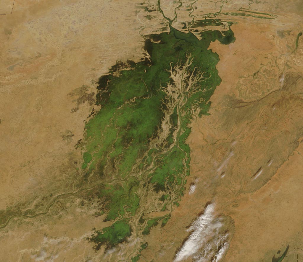
The MODIS on the Terra satellite took this picture of the Inland Niger Delta on November 11, 2007 shortly after the end of the rainy season when the landscape remained lush and green. This inland delta is a complex combination of river channels, lakes, swamps, and occasional areas of higher elevation. One such area of higher elevation is obvious in this image, and it forms a branching shape, like a tan tree pushing up toward the north. This wet oasis in the African Sahel provides habitat both for migrating birds and West African manatees. The fertile floodplains also provide much needed resources for the local people, who use the area for fishing, grazing livestock, and cultivating rice. |
| 日期 | |
| 来源 | http://modis.gsfc.nasa.gov/gallery/images/image11272007_250m.jpg |
| 作者 | Jeff Schmaltz, MODIS Land Rapid Response Team, NASA GSFC |
许可协议[编辑]
| 本文件完全由NASA创作,在美国属于公有领域。根据NASA的版权方针,NASA的材料除非另有声明否则不受版权保护。(参见Template:PD-USGov/zh、NASA版权方针页面或JPL图片使用方针。) | ||
 |
警告:
|
文件历史
点击某个日期/时间查看对应时刻的文件。
| 日期/时间 | 缩略图 | 大小 | 用户 | 备注 | |
|---|---|---|---|---|---|
| 当前 | 2007年11月30日 (五) 00:36 | | 1,024 × 888(167 KB) | Pmsyyz(留言 | 贡献) | {{Information |Description= en:Niger Inland Delta |Source= http://modis.gsfc.nasa.gov/gallery/images/image11272007_250m.jpg |Date= 2007-11-27 |Author= Jeff Schmaltz, MODIS Land Rapid Response Team, NASA GSFC |Permission= |other_versions= }} |
您不可以覆盖此文件。
文件用途
没有页面使用本文件。
全域文件用途
以下其他wiki使用此文件:
- ar.wikipedia.org上的用途
- ca.wikipedia.org上的用途
- cs.wikipedia.org上的用途
- de.wikipedia.org上的用途
- en.wikipedia.org上的用途
- eo.wikipedia.org上的用途
- es.wikipedia.org上的用途
- fr.wikipedia.org上的用途
- ig.wikipedia.org上的用途
- it.wikipedia.org上的用途
- ja.wikipedia.org上的用途
- lt.wikipedia.org上的用途
- nn.wikipedia.org上的用途
- pt.wikipedia.org上的用途
- vi.wikipedia.org上的用途
- www.wikidata.org上的用途
- zh.wikipedia.org上的用途