File:Io VGR South polar color mosaic.jpg
跳转到导航
跳转到搜索
本预览的尺寸:464 × 599像素。 其他分辨率:186 × 240像素 | 371 × 480像素 | 594 × 768像素 | 792 × 1,024像素 | 2,175 × 2,810像素。
原始文件 (2,175 × 2,810像素,文件大小:291 KB,MIME类型:image/jpeg)
说明
说明
添加一行文字以描述该文件所表现的内容
摘要
[编辑]| 描述 |
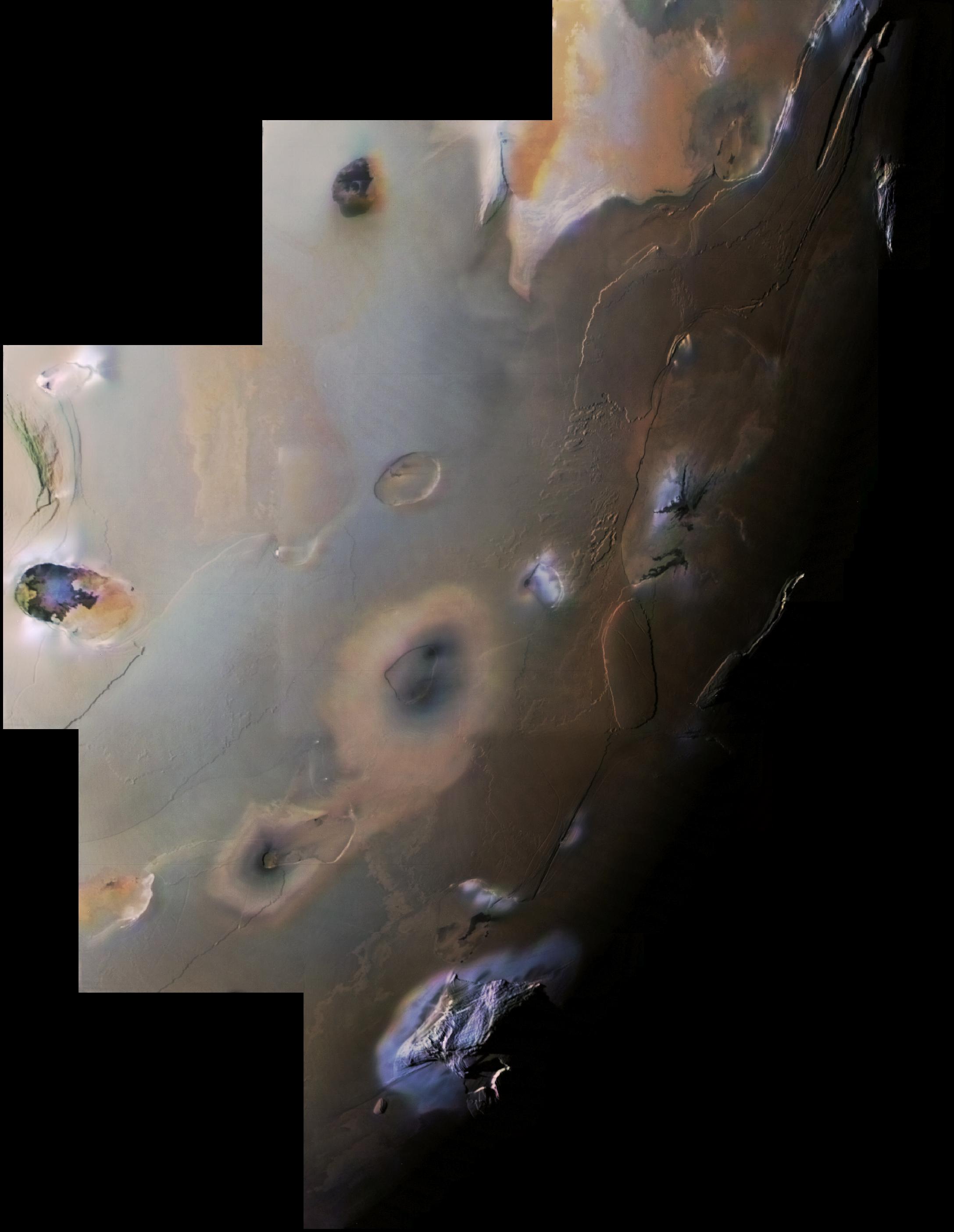
English: This Voyager 1 image mosaic shows Io's south polar region. The South Pole is near the terminator (line between daylight and night) at right center. Haemus Mons, a 10-km high (32,000 foot) mountain is at bottom. Elsewhere, much flatter volcanic plains, eroded volcanic plateaus, and crater-like volcanic calderas dominate the scene. The partly black-filled caldera at far left is Creidne Patera. The composition of the prevalent volcanic plains of Io could consist dominantly of sulfur with a thin discontinuous coating of sulfur dioxide frost or of silicates (such as basalt) coated with sulfurous condensates. The black material in Creidne Patera is where sulfur or silicates are probably still molten, whereas the brown material in the caldera is probably where the sulfur has solidified.
Many of the features in this image are annotated in Wikimedia Commons. |
| 日期 | |
| 来源 | http://photojournal.jpl.nasa.gov/catalog/PIA00327 |
| 作者 | NASA / Jet Propulsion Laboratory / USGS |
| 其他版本 |
|

| 此标签不表示文件的著作权状态。任何文件在附有此标签的同時还需要一个有效的著作权标签。请参阅许可协议说明页面以了解更多信息。 其他语言:
|
许可协议
[编辑]
| 本文件完全由NASA创作,在美国属于公有领域。根据NASA的版权方针,NASA的材料除非另有声明否则不受版权保护。(参见Template:PD-USGov/zh、NASA版权方针页面或JPL图片使用方针。) | ||
 |
警告:
|
原始上传日志
[编辑]
The original description page was here. All following user names refer to en.wikipedia.
- 2007-04-22 04:54 Volcanopele 2175×2810× (297821 bytes) This Voyager 1 image mosaic shows [[Io (moon)|]]'s south polar region. The South Pole is near the terminator (line between daylight and night) at right center. [[Haemus Mons]], a 10-km high (32,000 foot) mountain is at bottom. Elsewhere, much flatter volc
| 注解 | 该图片含有注解:在维基媒体共享资源上查看注解 |
文件历史
点击某个日期/时间查看对应时刻的文件。
| 日期/时间 | 缩略图 | 大小 | 用户 | 备注 | |
|---|---|---|---|---|---|
| 当前 | 2012年2月28日 (二) 18:49 | | 2,175 × 2,810(291 KB) | Cocu(留言 | 贡献) | {{Information |Description={{en|This Voyager 1 image mosaic shows Io's south polar region. The South Pole is near the terminator (line between daylight and night) at right center. en:Haemus Mons, a 10-km high (32,000 foot) mount... |
您不可以覆盖此文件。
文件用途
以下页面使用本文件:
全域文件用途
以下其他wiki使用此文件:
- ar.wikipedia.org上的用途
- bn.wikipedia.org上的用途
- ckb.wikipedia.org上的用途
- en.wikipedia.org上的用途
- en.wikibooks.org上的用途
- en.wikiversity.org上的用途
- eu.wikipedia.org上的用途
- fr.wikipedia.org上的用途
- hy.wikipedia.org上的用途
- id.wikipedia.org上的用途
- it.wikipedia.org上的用途
- ja.wikipedia.org上的用途
- ko.wikipedia.org上的用途
- mk.wikipedia.org上的用途
- no.wikipedia.org上的用途
- ro.wikipedia.org上的用途
- tr.wikipedia.org上的用途
- zh.wikipedia.org上的用途