File:Io VGR South polar color mosaic.jpg
跳至導覽
跳至搜尋
預覽大小:464 × 599 像素。 其他解析度:186 × 240 像素 | 371 × 480 像素 | 594 × 768 像素 | 792 × 1,024 像素 | 2,175 × 2,810 像素。
原始檔案 (2,175 × 2,810 像素,檔案大小:291 KB,MIME 類型:image/jpeg)
說明
說明
添加單行說明來描述出檔案所代表的內容
摘要
[編輯]| 描述 |
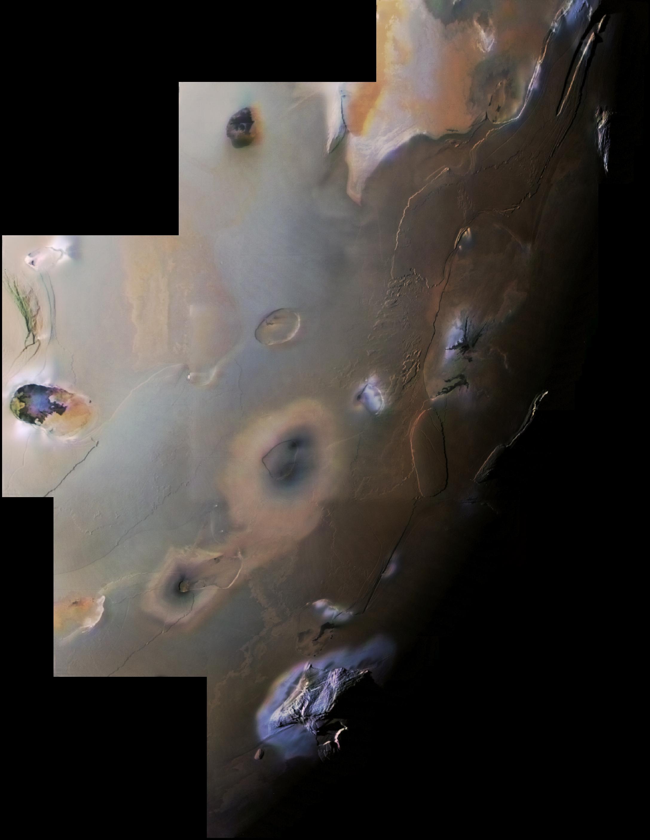
English: This Voyager 1 image mosaic shows Io's south polar region. The South Pole is near the terminator (line between daylight and night) at right center. Haemus Mons, a 10-km high (32,000 foot) mountain is at bottom. Elsewhere, much flatter volcanic plains, eroded volcanic plateaus, and crater-like volcanic calderas dominate the scene. The partly black-filled caldera at far left is Creidne Patera. The composition of the prevalent volcanic plains of Io could consist dominantly of sulfur with a thin discontinuous coating of sulfur dioxide frost or of silicates (such as basalt) coated with sulfurous condensates. The black material in Creidne Patera is where sulfur or silicates are probably still molten, whereas the brown material in the caldera is probably where the sulfur has solidified.
Many of the features in this image are annotated in Wikimedia Commons. |
| 日期 | |
| 來源 | http://photojournal.jpl.nasa.gov/catalog/PIA00327 |
| 作者 | NASA / Jet Propulsion Laboratory / USGS |
| 其他版本 |
|

| 此標籤不表示文件的著作權狀態。任何文件在附有此標籤的同時還需要一個有效的著作權標籤。請參閱許可協議說明頁面以了解更多資訊。 其他語言:
|
授權條款
[編輯]
| 本作品由NASA創作,屬於公有領域。根據NASA的版權政策:“NASA的創作除非另有聲明否則不受版權保護。”(參見:Template:PD-USGov/zh,NASA版權政策或JPL圖像使用政策) | ||
 |
警告:
|
原始上傳日誌
[編輯]
The original description page was here. All following user names refer to en.wikipedia.
- 2007-04-22 04:54 Volcanopele 2175×2810× (297821 bytes) This Voyager 1 image mosaic shows [[Io (moon)|]]'s south polar region. The South Pole is near the terminator (line between daylight and night) at right center. [[Haemus Mons]], a 10-km high (32,000 foot) mountain is at bottom. Elsewhere, much flatter volc
| 註解 | 該圖片含有註解:在維基媒體共享資源上查看註解 |
檔案歷史
點選日期/時間以檢視該時間的檔案版本。
| 日期/時間 | 縮圖 | 尺寸 | 使用者 | 備註 | |
|---|---|---|---|---|---|
| 目前 | 2012年2月28日 (二) 18:49 | | 2,175 × 2,810(291 KB) | Cocu(留言 | 貢獻) | {{Information |Description={{en|This Voyager 1 image mosaic shows Io's south polar region. The South Pole is near the terminator (line between daylight and night) at right center. en:Haemus Mons, a 10-km high (32,000 foot) mount... |
無法覆蓋此檔案。
檔案用途
下列頁面有用到此檔案:
全域檔案使用狀況
以下其他 wiki 使用了這個檔案:
- ar.wikipedia.org 的使用狀況
- bn.wikipedia.org 的使用狀況
- ckb.wikipedia.org 的使用狀況
- en.wikipedia.org 的使用狀況
- en.wikibooks.org 的使用狀況
- en.wikiversity.org 的使用狀況
- eu.wikipedia.org 的使用狀況
- fr.wikipedia.org 的使用狀況
- hy.wikipedia.org 的使用狀況
- id.wikipedia.org 的使用狀況
- it.wikipedia.org 的使用狀況
- ja.wikipedia.org 的使用狀況
- ko.wikipedia.org 的使用狀況
- mk.wikipedia.org 的使用狀況
- no.wikipedia.org 的使用狀況
- ro.wikipedia.org 的使用狀況
- tr.wikipedia.org 的使用狀況
- zh.wikipedia.org 的使用狀況