File:Iquitos Mapa de distritos 03.svg
Jump to navigation
Jump to search

Size of this PNG preview of this SVG file: 542 × 600 pixels. Other resolutions: 217 × 240 pixels | 434 × 480 pixels | 694 × 768 pixels | 925 × 1,024 pixels | 1,850 × 2,048 pixels | 1,665 × 1,843 pixels.
Original file (SVG file, nominally 1,665 × 1,843 pixels, file size: 152 KB)
Captions
Captions
Add a one-line explanation of what this file represents
Summary[edit]
| Description |
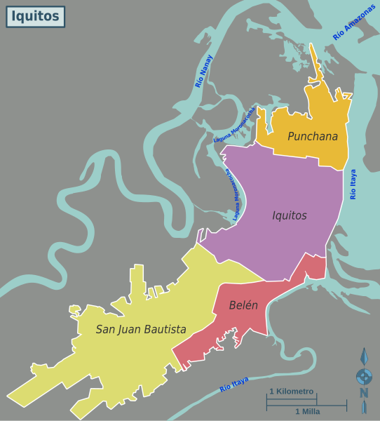
Español: Mapa de la ciudad de Iquitos, Perú con sus cuatro distritos (2015) y los ríos que la rodean. English: Map of Iquitos, Perú, featuring its four districts (2015) and rivers surrounding it. |
| Date | |
| Source | Own work |
| Author | EdwinJs |
Licensing[edit]
I, the copyright holder of this work, hereby publish it under the following license:
This file is licensed under the Creative Commons Attribution-Share Alike 4.0 International license.
- You are free:
- to share – to copy, distribute and transmit the work
- to remix – to adapt the work
- Under the following conditions:
- attribution – You must give appropriate credit, provide a link to the license, and indicate if changes were made. You may do so in any reasonable manner, but not in any way that suggests the licensor endorses you or your use.
- share alike – If you remix, transform, or build upon the material, you must distribute your contributions under the same or compatible license as the original.
File history
Click on a date/time to view the file as it appeared at that time.
| Date/Time | Thumbnail | Dimensions | User | Comment | |
|---|---|---|---|---|---|
| current | 14:35, 24 September 2015 | | 1,665 × 1,843 (152 KB) | EdwinJs (talk | contribs) | Corrección de error en escala. |
| 14:17, 24 September 2015 |  | 1,665 × 1,843 (152 KB) | EdwinJs (talk | contribs) | User created page with UploadWizard |
You cannot overwrite this file.
File usage on Commons
The following 2 pages use this file:
File usage on other wikis
The following other wikis use this file:
- Usage on en.wikipedia.org