File:Iran ethnoreligious distribution 2004.jpg
Aller à la navigation
Aller à la recherche

Taille de cet aperçu : 606 × 600 pixels. Autres résolutions : 242 × 240 pixels | 485 × 480 pixels | 980 × 970 pixels.
Fichier d’origine (980 × 970 pixels, taille du fichier : 308 kio, type MIME : image/jpeg)
Légendes
Légendes
Ajoutez en une ligne la description de ce que représente ce fichier

Description
[modifier]
| Description |
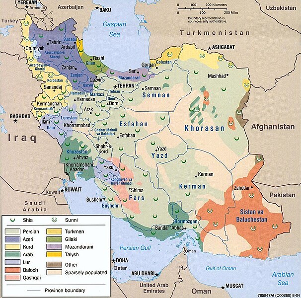
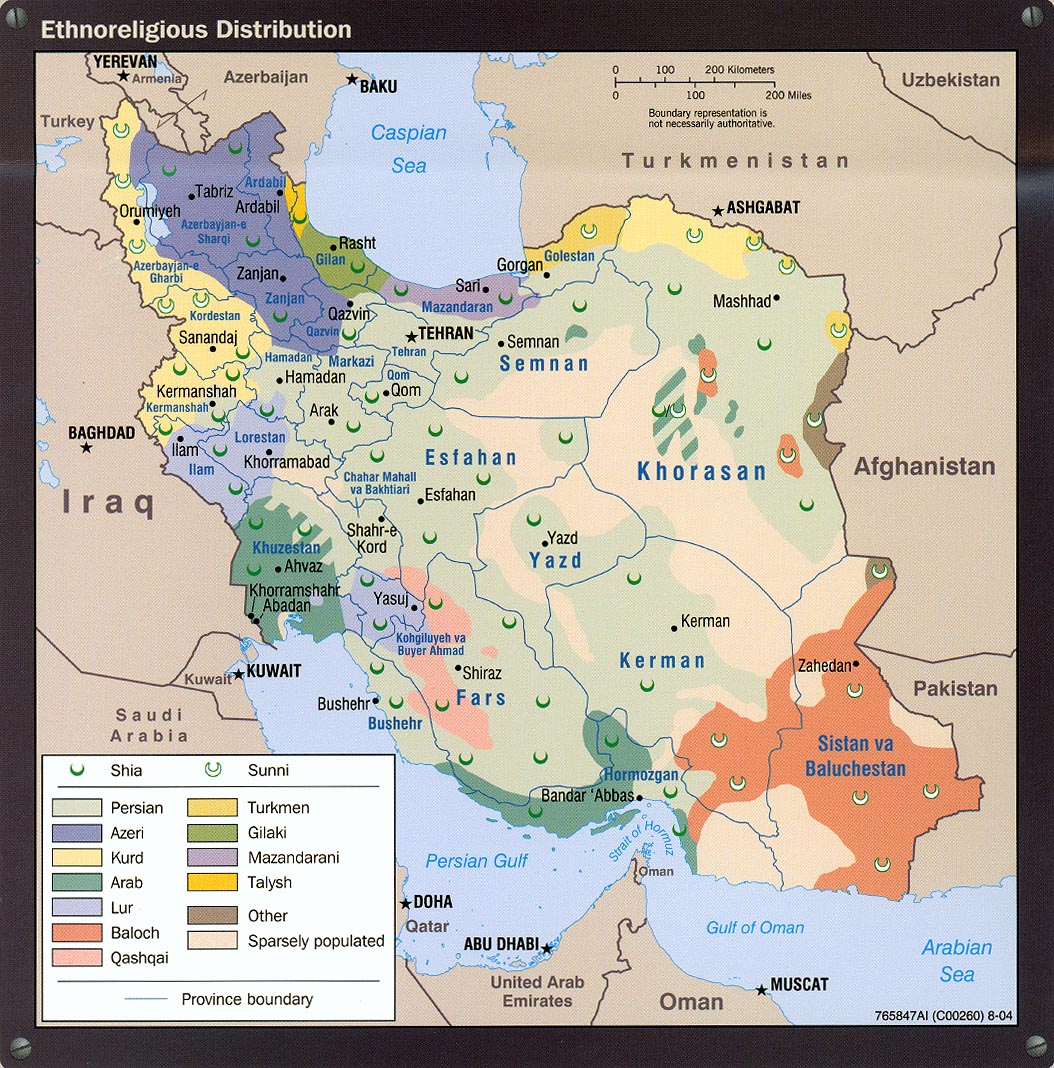
Bahasa Melayu: Iran — peta taburan etnik berdasarkan agama.
فارسی: نقشهٔ پراکنش قومی و مذهبی ایران در ۲۰۰۴ (انگلیسی) |
| Source | http://www.lib.utexas.edu/maps/middle_east_and_asia/iran_ethnoreligious_distribution_2004.jpg |
| Auteur | Central Intelligence Agency |
| Autorisation (Réutilisation de ce fichier) |
Above the list of maps available for download, the web site has the text: The following maps were produced by the U.S. Central Intelligence Agency, unless otherwise indicated. There is no indication that this map was not produced by the CIA. |
Conditions d’utilisation
[modifier]
| Cette image est une œuvre d'un employé de la Central Intelligence Agency, réalisée dans le cadre des tâches officielles de cette personne. En tant qu’œuvre du Gouvernement des États-Unis d'Amérique, ce document est placé dans le domaine public aux États-Unis d'Amérique.
|

|
Historique du fichier
Cliquer sur une date et heure pour voir le fichier tel qu'il était à ce moment-là.
| Date et heure | Vignette | Dimensions | Utilisateur | Commentaire | |
|---|---|---|---|---|---|
| actuel | 28 juillet 2021 à 17:38 | | 980 × 970 (308 kio) | GPinkerton (d | contributions) | Reverted to version as of 20:33, 13 December 2005 (UTC) Back to the original image, yet again. See https://lccn.loc.gov/2005634048 for the original 2004 CIA "Iran country profile" info-graphic of which this map is a part. |
| 23 février 2015 à 18:24 |  | 980 × 970 (419 kio) | Lantad (d | contributions) | original map is not correct | |
| 23 décembre 2014 à 02:05 |  | 980 × 970 (308 kio) | Abrahamic Faiths (d | contributions) | I assume that User:HistoryofIran reverted to this version by mistake, the lurs are not this widely spread, keep consistent with this map | |
| 8 octobre 2014 à 14:02 |  | 980 × 970 (419 kio) | HistoryofIran (d | contributions) | Removed vandalism by puppet account. | |
| 28 septembre 2014 à 14:07 |  | 980 × 970 (419 kio) | Apiculate (d | contributions) | You are going to say half of lorestan province are not lur ? | |
| 28 septembre 2014 à 14:06 |  | 980 × 970 (419 kio) | Apiculate (d | contributions) | You are going to say half of lorestan province are not lur ? | |
| 14 septembre 2014 à 18:57 |  | 980 × 970 (308 kio) | HistoryofIran (d | contributions) | Removed disprutive edit; that doesn't make any sense. | |
| 11 septembre 2014 à 22:25 |  | 980 × 970 (419 kio) | Apiculate (d | contributions) | in ethnologue, Bakhtiari considered a dialect of luri language ,Source: http://www.ethnologue.com/language/bqi/view/***EDITION*** | |
| 15 août 2014 à 16:12 |  | 980 × 970 (308 kio) | HistoryofIran (d | contributions) | Removed disprutive edit. | |
| 7 août 2014 à 10:56 |  | 980 × 970 (419 kio) | Apiculate (d | contributions) | Reverted to version as of 06:16, 6 June 2014 |
Vous ne pouvez pas remplacer ce fichier.
Utilisations locales du fichier
Les 9 pages suivantes utilisent ce fichier :
- Atlas of Kurdistan
- User talk:Hedwig in Washington/Archive 1
- Commons:Graphic Lab/Map workshop/Archive/2015
- Commons:Village pump/Archive/2014/09
- File:2004 Iran ethnoreligious distribution by the CIA (western Iran).jpg
- File:Iran-Ethnic map.PNG
- File:Iran-Ethnicity-2004.PNG
- File:Iran ethnoreligious distribution 2004b.JPG (redirection de fichier)
- File talk:1946 Kurdistan et groupements Kurdes isolés.jpg
.jpg)
Utilisations du fichier sur d’autres wikis
Les autres wikis suivants utilisent ce fichier :
- Utilisation sur af.wikipedia.org
- Utilisation sur av.wikipedia.org
- Utilisation sur ba.wikipedia.org
- Utilisation sur cs.wikipedia.org
- Utilisation sur de.wikipedia.org
- Utilisation sur en.wikipedia.org
- Utilisation sur en.wikinews.org
- Utilisation sur fa.wikipedia.org
- Utilisation sur he.wikipedia.org
- Utilisation sur hr.wikipedia.org
- Utilisation sur hu.wikipedia.org
- Utilisation sur it.wikipedia.org
- Utilisation sur ka.wikipedia.org
- Utilisation sur nl.wikipedia.org
- Utilisation sur nn.wikipedia.org
- Utilisation sur no.wikipedia.org
- Utilisation sur pt.wikipedia.org
- Utilisation sur ru.wikipedia.org
- Utilisation sur sh.wikipedia.org
- Utilisation sur simple.wikipedia.org
- Utilisation sur sr.wikipedia.org
- Utilisation sur tg.wikipedia.org
- Utilisation sur tr.wikipedia.org
- Utilisation sur tt.wikipedia.org
- Utilisation sur zh.wikipedia.org