File:Iraq marshes buffer maps UNESCO.png
Jump to navigation
Jump to search

Size of this preview: 800 × 564 pixels. Other resolutions: 320 × 225 pixels | 640 × 451 pixels | 1,024 × 722 pixels | 1,280 × 902 pixels | 1,527 × 1,076 pixels.
Original file (1,527 × 1,076 pixels, file size: 878 KB, MIME type: image/png)
Captions
Captions
Add a one-line explanation of what this file represents
Summary
[edit]
| Description |
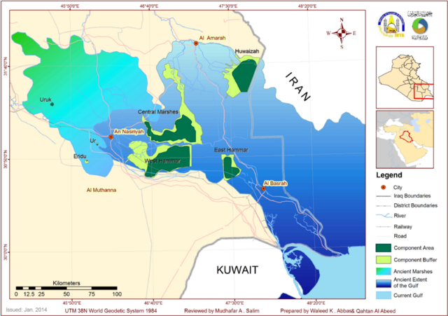
العربية: خريطة لمواقع الأهوار العراقية المُدرجة على قائمة التراث العالمي (أخضر غامق) عام 2016، ومناطق الحماية المحيطة بها (أخضرفاتح) وفقًا لمتطلبات اليونسكو. يظهر أيضًا مناطق امتدادات الأهوار قديمًا (أخضر) وامتداد مياه الخليج قديمًا (أزرق غامق). |
| Date | |
| Source | https://whc.unesco.org/en/list/1481/documents/ |
| Author | UNESCO |
Licensing
[edit]
This file is licensed under the Creative Commons Attribution-Share Alike 4.0 International license.
- You are free:
- to share – to copy, distribute and transmit the work
- to remix – to adapt the work
- Under the following conditions:
- attribution – You must give appropriate credit, provide a link to the license, and indicate if changes were made. You may do so in any reasonable manner, but not in any way that suggests the licensor endorses you or your use.
- share alike – If you remix, transform, or build upon the material, you must distribute your contributions under the same or compatible license as the original.
File history
Click on a date/time to view the file as it appeared at that time.
| Date/Time | Thumbnail | Dimensions | User | Comment | |
|---|---|---|---|---|---|
| current | 17:51, 19 December 2023 | | 1,527 × 1,076 (878 KB) | Freedom's Falcon (talk | contribs) | Uploaded a work by UNESCO from https://whc.unesco.org/en/list/1481/documents/ with UploadWizard |
You cannot overwrite this file.
File usage on Commons
There are no pages that use this file.