File:Irma 2017-09-05 1706Z.jpg
跳转到导航
跳转到搜索
本预览的尺寸:450 × 600像素。 其他分辨率:180 × 240像素 | 360 × 480像素 | 576 × 768像素 | 768 × 1,024像素 | 1,536 × 2,048像素 | 4,950 × 6,600像素。
原始文件 (4,950 × 6,600像素,文件大小:8.39 MB,MIME类型:image/jpeg)
说明
说明
添加一行文字以描述该文件所表现的内容
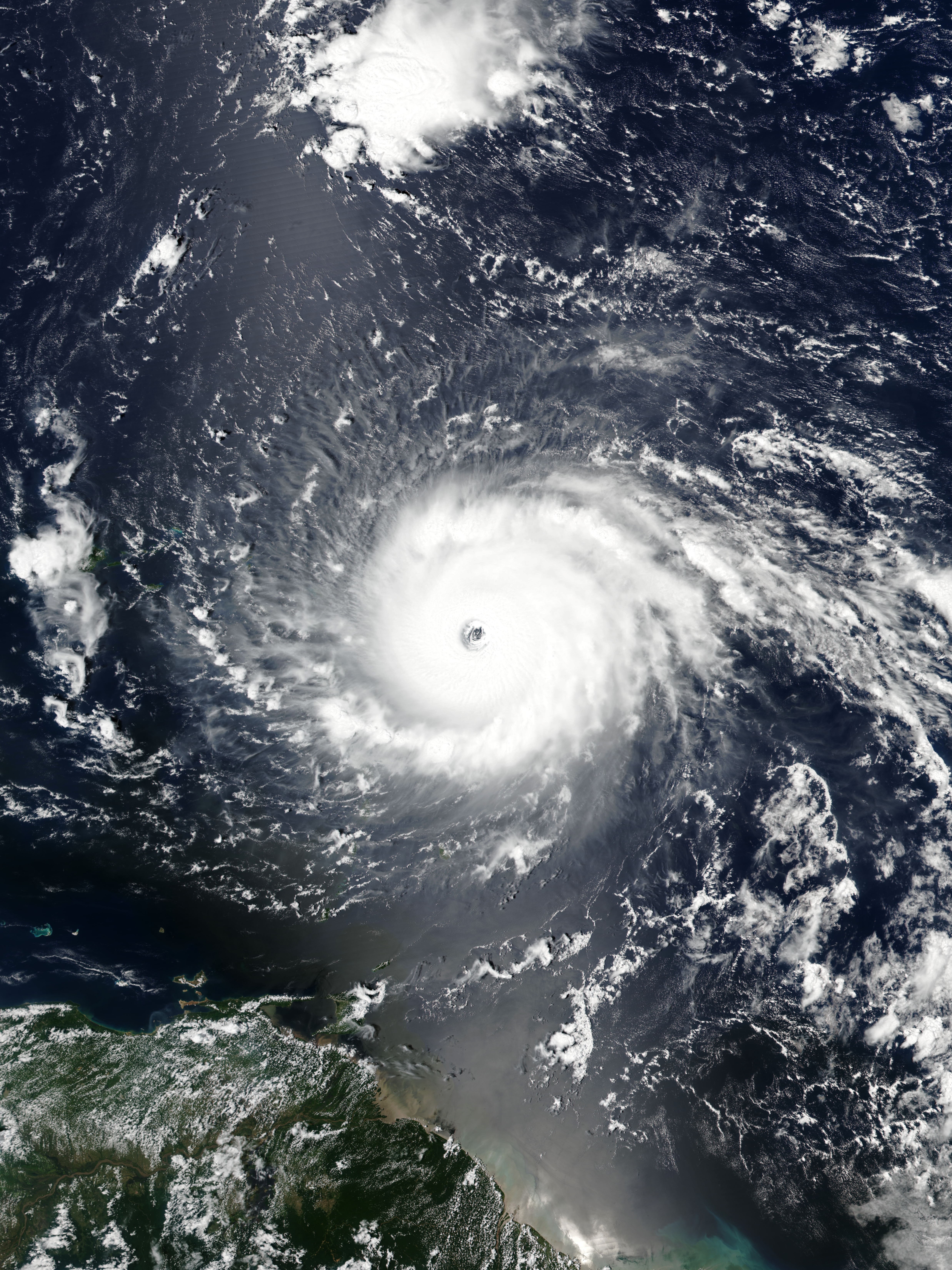
Hurricane Irma
摘要
[编辑]
| 描述 |
English: Hurricane Irma approaching the Leeward Islands at peak intensity on September 5, 2017 as the third most intense Atlantic hurricane on record in terms of sustained winds. |
| 日期 | |
| 来源 | EOSDIS Worldview |
| 作者 | VIIRS image captured by NOAA’s Suomi NPP satellite |
| 相机位置 | | 在以下服务上查看本图像和附近其他图像: OpenStreetMap |
|---|
许可协议
[编辑]
| 本文件完全由NASA创作,在美国属于公有领域。根据NASA的版权方针,NASA的材料除非另有声明否则不受版权保护。(参见Template:PD-USGov/zh、NASA版权方针页面或JPL图片使用方针。) | ||
 |
警告:
|
文件历史
点击某个日期/时间查看对应时刻的文件。
| 日期/时间 | 缩略图 | 大小 | 用户 | 备注 | |
|---|---|---|---|---|---|
| 当前 | 2021年5月15日 (六) 01:21 | | 4,950 × 6,600(8.39 MB) | Supportstorm(留言 | 贡献) | Reverted to version as of 21:19, 5 September 2017 (UTC) |
| 2021年5月15日 (六) 00:12 |  | 437 × 452(89 KB) | Super Cyclonic Storm Corona(留言 | 贡献) | Crop a bit. | |
| 2017年9月5日 (二) 21:19 |  | 4,950 × 6,600(8.39 MB) | Meow(留言 | 贡献) | User created page with UploadWizard |
您不可以覆盖此文件。
文件用途
以下4个页面使用本文件:
.jpg)
全域文件用途
以下其他wiki使用此文件:
- cs.wikipedia.org上的用途
- en.wikipedia.org上的用途
- Portal:Tropical cyclones/Anniversaries/September
- Portal:Tropical cyclones/Anniversaries/September/5
- User:LightandDark2000/My Notable Storms
- Talk:Hurricane Irma/Archive 2
- User:Tfmbty/List of the most intense tropical cyclones since 1979
- User talk:36.82.216.113
- Talk:2018 Atlantic hurricane season/Archive 2
- User talk:82.8.147.67
- es.wikipedia.org上的用途
- et.wikipedia.org上的用途
- hu.wikipedia.org上的用途
- pt.wikipedia.org上的用途
- ru.wikipedia.org上的用途
- sd.wikipedia.org上的用途
- sr.wikipedia.org上的用途
- th.wikipedia.org上的用途
- uk.wikipedia.org上的用途
- uz.wikipedia.org上的用途
- zh.wikipedia.org上的用途