File:Isla Hoste.png
跳转到导航
跳转到搜索
没有更高的分辨率。
Isla_Hoste.png (391 × 500像素,文件大小:410 KB,MIME类型:image/png)
说明
说明
添加一行文字以描述该文件所表现的内容
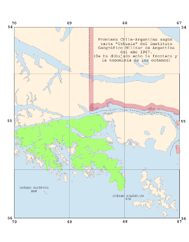
| 描述 | w:Hoste Island on a map of the southern part of the Archipelago of Tierra del Fuego, Borderline Chile-Argentina according to a map edited 1967 by the Argentine "Instituto Geografico Militar". The map is included in the book "El Conflicto del Beagle", edited by the Chilean Foreign Affairs Office, 1978, Switzerland. | ||||||||||
| 日期 | (UTC) | ||||||||||
| 来源 |
based on Image:Ushuaia.igm.arg.1967.png, changes made by myself self-made |
||||||||||
| 作者 | this image: Man77, source made by User:Createaccount | ||||||||||
| 授权 (二次使用本文件) |
|

文件历史
点击某个日期/时间查看对应时刻的文件。
| 日期/时间 | 缩略图 | 大小 | 用户 | 备注 | |
|---|---|---|---|---|---|
| 当前 | 2008年3月28日 (五) 14:20 | | 391 × 500(410 KB) | Man77(留言 | 贡献) | {{Information |Description=w:Hoste Island on a map of the southern part of the Archipelago of Tierra del Fuego, Borderline Chile-Argentina according to a map edited 1967 by the Argentine "Instituto Geografico Militar". The map is included in the book |
您不可以覆盖此文件。
文件用途
没有页面使用本文件。
全域文件用途
以下其他wiki使用此文件:
- ca.wikipedia.org上的用途
- fr.wikipedia.org上的用途
- it.wikipedia.org上的用途
- sh.wikipedia.org上的用途
- www.wikidata.org上的用途
- zh.wikipedia.org上的用途