File:Isle of Jersey (ASTER).jpg
跳转到导航
跳转到搜索

本预览的尺寸:763 × 600像素。 其他分辨率:306 × 240像素 | 611 × 480像素 | 978 × 768像素 | 1,280 × 1,006像素 | 1,400 × 1,100像素。
原始文件 (1,400 × 1,100像素,文件大小:231 KB,MIME类型:image/jpeg)
说明
说明
添加一行文字以描述该文件所表现的内容
摘要[编辑]
.jpg&action=edit§ion=1)
| 描述 |
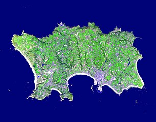
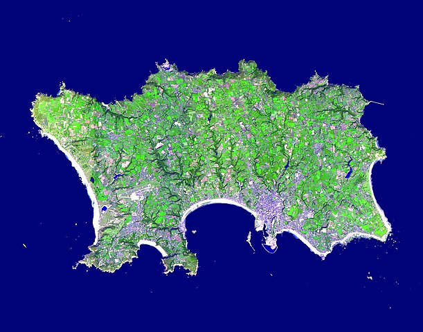
English: The Isle of Jersey (officially called the Bailiwick of Jersey) is the largest Channel Island, positioned in the Bay of Mont St Michel off the north-west coast of France. The island has a population of about 90,000, and covers about 90 square kilometers. The economy is based largely on international financial services, agriculture, and tourism. Called Caesaria in Roman times, Jersey became part of the Duchy of Normandy in 912. When William the Conqueror invaded and took the throne of England in 1066, the fortunes of Jersey then became linked to those in England, although the island manages its internal affairs through its own parliament, the States of Jersey. This image was acquired September 23, 2000, covers an area of 16.5 x 21 km, and is located at 49.2 degrees north latitude and 2.1 degrees west longitude |
||
| 日期 | 摄于2000年9月23日 | ||
| 来源 |
|
||
| 作者 | NASA/METI/AIST/Japan Space Systems, and U.S./Japan ASTER Science Team |
| 相机位置 | | 在以下服务上查看本图像和附近其他图像: OpenStreetMap |
|---|
.jpg¶ms=049.200000_N_-002.100000_E_globe:Earth_type:camera__&language=zh-cn)
许可协议[编辑]
.jpg&action=edit§ion=2)
| 本文件完全由NASA创作,在美国属于公有领域。根据NASA的版权方针,NASA的材料除非另有声明否则不受版权保护。(参见Template:PD-USGov/zh、NASA版权方针页面或JPL图片使用方针。) | ||
 |
警告:
|
文件历史
点击某个日期/时间查看对应时刻的文件。
| 日期/时间 | 缩略图 | 大小 | 用户 | 备注 | |
|---|---|---|---|---|---|
| 当前 | 2023年4月30日 (日) 15:48 | | 1,400 × 1,100(231 KB) | OptimusPrimeBot(留言 | 贡献) | #Spacemedia - Upload of https://asterweb.jpl.nasa.gov/gallery/images/jersey.jpg via Commons:Spacemedia |
您不可以覆盖此文件。
文件用途
以下5个页面使用本文件:
全域文件用途
以下其他wiki使用此文件:
- br.wikipedia.org上的用途
- en.wikipedia.org上的用途
- Minquiers and Ecréhous
- Saint Aubin, Jersey
- Les Dirouilles
- Vingtaine de Noirmont
- Vingtaine du Coin
- Vingtaine des Quennevais
- Vingtaine de la Moye
- Vingtaine de Samarès
- Grande Vingtaine (St Clement)
- Vingtaine du Rocquier
- Vingtaine de la Rocque
- Vingtaine des Marais
- Vingtaine de la Rue
- Vingtaine de Longueville
- Vingtaine du Rouge Bouillon
- Vingtaine de Bas du Mont au Prêtre
- Vingtaine du Mont à l'Abbé
- Vingtaine de Haut du Mont au Prêtre
- Vingtaine du Mont Cochon
- St Michael's Preparatory School
- Grouville Church
- St Peter la Rocque
- Vingtaine du Nord (St John)
- Vingtaine de Hérupe
- Vingtaine du Douet (St John)
- Template:Jersey-geo-stub
- Outline of Jersey
- Nicolle Tower
- Vingtaine de la Vallée
- Vingtaine du Coin Hâtain
- Vingtaine du Coin Motier
- Vingtaine du Coin Tourgis Sud
- Les Platons
- HM Prison La Moye
- Vingtaine du Nord (St Mary)
- Grainville School
- St Matthew's Church, Jersey
- Gulf of Saint-Malo
- Samarès Manor
- Saint Ouen's Manor
- FB Playing Fields
- Saint Helier Marina
- Vingtaine du Sud
- Vingtaine de Rozel
- Vingtaine de Faldouet
- Vingtaine de la Quéruée
- Vingtaine des Augrès
- Le Pinacle
- Beaulieu Convent School
查看此文件的更多全域用途。
.jpg)
.jpg&oldid=814910643)