File:Isles Dernieres.gif
跳至導覽
跳至搜尋
無更高解析度可提供。
Isles_Dernieres.gif (481 × 576 像素,檔案大小:23 KB,MIME 類型:image/gif)
說明
說明
添加單行說明來描述出檔案所代表的內容
檔案歷史
點選日期/時間以檢視該時間的檔案版本。
| 日期/時間 | 縮圖 | 尺寸 | 用戶 | 備註 | |
|---|---|---|---|---|---|
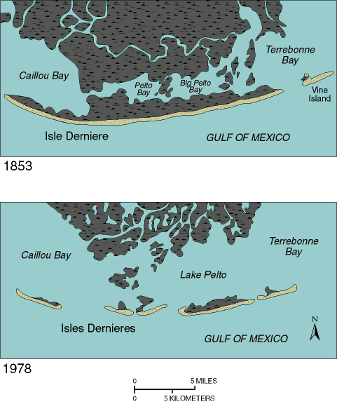
| 目前 | 2009年11月15日 (日) 14:08 | | 481 × 576(23 KB) | Dono17(對話 | 貢獻) | {{Information |Description={{en|1=Geographical comparison of the landscape around Isles Dernieres in 1853 and 1978}} |Source=http://pubs.usgs.gov/circ/c1075/dernieres.html |Author=Modified from Penland and others, 1989. |Date=1997-09-16 |Permission= |othe |
無法覆蓋此檔案。
檔案用途
沒有使用此檔案的頁面。
全域檔案使用狀況
以下其他 wiki 使用了這個檔案:
- az.wikipedia.org 的使用狀況
- en.wikipedia.org 的使用狀況
- es.wikipedia.org 的使用狀況
- fr.wikipedia.org 的使用狀況
- ru.wikipedia.org 的使用狀況
- tr.wikipedia.org 的使用狀況
- vi.wikipedia.org 的使用狀況
- zh.wikipedia.org 的使用狀況