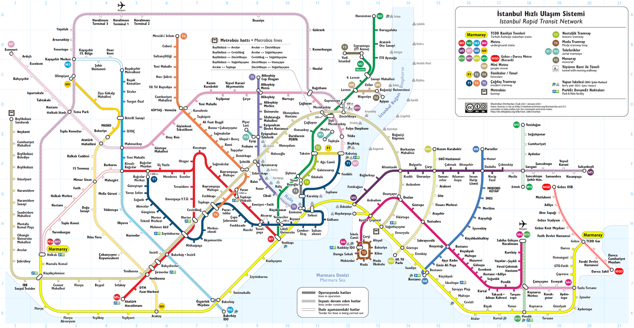
File:Istanbul Rapid Transit Map with Metrobüs (schematic).png

Fichier d’origine (3 828 × 1 979 pixels, taille du fichier : 1,75 Mio, type MIME : image/png)
Légendes
Légendes
Need Assistance!
I don't live in Turkey and the map basically was drawn after some informations from the Web which are often incorrect or very inaccurate. So if you want the network map as accurate as possible too, please announce your error hints and corrections on my German discussion page.
Thank you!
Description
[modifier]| Description |
|
|||
| Date | see file history | |||
| Source | Travail personnel | |||
| Auteur | Maximilian Dörrbecker (Chumwa) | |||
| Autorisation (Réutilisation de ce fichier) |
Moi, en tant que détenteur des droits d’auteur sur cette œuvre, je la publie sous la licence suivante : Ce fichier est disponible selon les termes de la licence Creative Commons Attribution – Partage dans les Mêmes Conditions 2.5 Générique
Sie dürfen das Bild zu den folgenden Bedingungen nutzen:
|
|||
| Autres versions |
Current maps:
Older maps (not longer maintained):
|

.png)


.png)
.png)
.png&action=edit§ion=1)

|
Cette image (de type transport map) devrait être recréée dans un format vectoriel, en tant que fichier SVG. Cela offrirait plusieurs avantages : voir Commons:Media for cleanup pour plus d'informations. Si une version SVG de cette image est déjà disponible, merci de bien vouloir l'envoyer. Après cela, remplacez ce modèle par {{vector version available|nouveau nom d'image.svg}}.
|
Historique du fichier
Cliquer sur une date et heure pour voir le fichier tel qu'il était à ce moment-là.
.png&uselang=fr&dir=prev)
.png&uselang=fr&offset=20180708080459)
.png&uselang=fr&offset=&limit=20)
.png&uselang=fr&offset=&limit=50)
.png&uselang=fr&offset=&limit=100)
.png&uselang=fr&offset=&limit=250)
.png&uselang=fr&offset=&limit=500)
| Date et heure | Vignette | Dimensions | Utilisateur | Commentaire | |
|---|---|---|---|---|---|
| actuel | 10 janvier 2023 à 15:34 | | 3 828 × 1 979 (1,75 Mio) | Alikam1896 (d | contributions) | 2023 |
| 3 janvier 2021 à 06:32 |  | 3 828 × 1 979 (1,24 Mio) | Chumwa (d | contributions) | ||
| 7 novembre 2020 à 08:57 |  | 3 828 × 1 979 (1,24 Mio) | Chumwa (d | contributions) | update | |
| 13 juin 2020 à 07:56 |  | 3 828 × 1 979 (1,26 Mio) | Chumwa (d | contributions) | update | |
| 7 avril 2019 à 20:23 |  | 4 497 × 2 441 (1,54 Mio) | Chumwa (d | contributions) | ||
| 31 mars 2019 à 17:34 |  | 3 646 × 1 979 (1,15 Mio) | Chumwa (d | contributions) | update | |
| 14 mars 2019 à 20:40 |  | 3 645 × 1 798 (1,1 Mio) | Chumwa (d | contributions) | update | |
| 30 octobre 2018 à 20:45 |  | 3 645 × 1 798 (1,1 Mio) | Chumwa (d | contributions) | update | |
| 26 juillet 2018 à 17:35 |  | 3 645 × 1 798 (1,1 Mio) | Chumwa (d | contributions) | update | |
| 8 juillet 2018 à 08:04 |  | 3 645 × 1 798 (1,07 Mio) | Chumwa (d | contributions) | update |
Vous ne pouvez pas remplacer ce fichier.
Utilisations locales du fichier
Plus de 100 pages utilisent ce fichier. La liste suivante affiche seulement les 100 premières pages qui utilisent ce fichier. Une liste complète est disponible.
.png)
- Top 200 transport map images that should use vector graphics
- Transit maps
- İstanbul
- User:Chumwa/Gallery
- User:Chumwa/Istanbul.kml
- User:Chumwa/Istanbul Public Transport Maps
- User:Chumwa/OgreBot/Potential transport maps/2016 August 21-31
- User:Chumwa/OgreBot/Potential transport maps/2016 December 11-20
- User:Chumwa/OgreBot/Potential transport maps/2016 June 1-10
- User:Chumwa/OgreBot/Potential transport maps/2016 May 1-10
- User:Chumwa/OgreBot/Potential transport maps/2016 November 11-20
- User:Chumwa/OgreBot/Potential transport maps/2017 April 21-30
- User:Chumwa/OgreBot/Potential transport maps/2017 December 11-20
- User:Chumwa/OgreBot/Potential transport maps/2017 December 21-31
- User:Chumwa/OgreBot/Potential transport maps/2018 July 1-10
- User:Chumwa/OgreBot/Potential transport maps/2018 July 21-31
- User:Chumwa/OgreBot/Potential transport maps/2018 October 21-31
- User:Chumwa/OgreBot/Potential transport maps/2019 March 11-20
- User:Chumwa/OgreBot/Public transport information/2015 April 11-20
- User:Chumwa/OgreBot/Public transport information/2015 August 11-20
- User:Chumwa/OgreBot/Public transport information/2015 February 1-9
- User:Chumwa/OgreBot/Public transport information/2015 June 11-20
- User:Chumwa/OgreBot/Public transport information/2016 August 21-31
- User:Chumwa/OgreBot/Public transport information/2016 December 11-20
- User:Chumwa/OgreBot/Public transport information/2016 June 1-10
- User:Chumwa/OgreBot/Public transport information/2016 May 1-10
- User:Chumwa/OgreBot/Public transport information/2016 November 11-20
- User:Chumwa/OgreBot/Public transport information/2017 April 21-30
- User:Chumwa/OgreBot/Public transport information/2017 December 11-20
- User:Chumwa/OgreBot/Public transport information/2017 December 21-31
- User:Chumwa/OgreBot/Public transport information/2018 July 1-10
- User:Chumwa/OgreBot/Public transport information/2018 July 21-31
- User:Chumwa/OgreBot/Public transport information/2018 October 21-31
- User:Chumwa/OgreBot/Public transport information/2019 March 11-20
- User:Chumwa/OgreBot/Public transport information/2019 March 21-31
- User:Chumwa/OgreBot/Transport Maps/2015 April 11-20
- User:Chumwa/OgreBot/Transport Maps/2015 August 11-20
- User:Chumwa/OgreBot/Transport Maps/2015 February 1-9
- User:Chumwa/OgreBot/Transport Maps/2015 June 11-20
- User:Chumwa/OgreBot/Transport Maps/2016 August 21-31
- User:Chumwa/OgreBot/Transport Maps/2016 December 11-20
- User:Chumwa/OgreBot/Transport Maps/2016 June 1-10
- User:Chumwa/OgreBot/Transport Maps/2016 May 1-10
- User:Chumwa/OgreBot/Transport Maps/2016 November 11-20
- User:Chumwa/OgreBot/Transport Maps/2017 April 21-30
- User:Chumwa/OgreBot/Transport Maps/2017 December 11-20
- User:Chumwa/OgreBot/Transport Maps/2017 December 21-31
- User:Chumwa/OgreBot/Transport Maps/2018 July 1-10
- User:Chumwa/OgreBot/Transport Maps/2018 July 21-31
- User:Chumwa/OgreBot/Transport Maps/2018 October 21-31
- User:Chumwa/OgreBot/Transport Maps/2019 March 11-20
- User:Chumwa/OgreBot/Transport Maps/2019 March 21-31
- User:Chumwa/OgreBot/Travel and communication maps/2016 August 21-31
- User:Chumwa/OgreBot/Travel and communication maps/2016 December 11-20
- User:Chumwa/OgreBot/Travel and communication maps/2016 June 1-10
- User:Chumwa/OgreBot/Travel and communication maps/2016 May 1-10
- User:Chumwa/OgreBot/Travel and communication maps/2016 November 11-20
- User:Chumwa/OgreBot/Travel and communication maps/2017 April 21-30
- User:Chumwa/OgreBot/Travel and communication maps/2017 December 11-20
- User:Chumwa/OgreBot/Travel and communication maps/2017 December 21-31
- User:Chumwa/OgreBot/Travel and communication maps/2018 July 1-10
- User:Chumwa/OgreBot/Travel and communication maps/2018 July 21-31
- User:Chumwa/OgreBot/Travel and communication maps/2018 October 21-31
- User:Chumwa/OgreBot/Travel and communication maps/2019 March 11-20
- User:Chumwa/OgreBot/Travel and communication maps/2019 March 21-31
- User:Chumwa/OtherVersions - Public transport Maps - Istanbul
- User:Liesel/Rail transport/2015 February 1-9
- File:Istanbul M2 Linienband.png
- File:Istanbul M3 Linienband.png
- File:Istanbul M4 Linienband.png
- File:Istanbul Metrobüs Lines.png
- File:Istanbul Rapid Transit Map.png
- File:Istanbul Rapid Transit Map (including future projects).png
- File:Istanbul Rapid Transit Map (schematic).png
- File:Istanbul Rapid Transit Map with Metrobüs (schematic).png
- File:Istanbul public transport - Banliyö Treni line symbol.png
- File:Istanbul public transport - F1 line symbol.png
- File:Istanbul public transport - M1 line symbol.png
- File:Istanbul public transport - M2 line symbol.png
- File:Istanbul public transport - M3 line symbol.png
- File:Istanbul public transport - M4 line symbol.png
- File:Istanbul public transport - M5 line symbol.png
- File:Istanbul public transport - M6 line symbol.png
- File:Istanbul public transport - M7 line symbol.png
- File:Istanbul public transport - M8 line symbol.png
- File:Istanbul public transport - M9 line symbol.png
- File:Istanbul public transport - MM line symbol.png
- File:Istanbul public transport - Metrobüs line symbol.png
- File:Istanbul public transport - Nostaljik Tramvay symbol.png
- File:Istanbul public transport - T1 line symbol.png
- File:Istanbul public transport - T3 line symbol.png
- File:Istanbul public transport - T4 line symbol.png
- File:Istanbul public transport - Teleferik line symbol.png
- File:Istanbul public transport - Tünel line symbol.png
- File:Istanbul public transport icons.svg
- File:Map of the Districts of Istanbul.png
- File:Map of the Istanbul Metro line M1A and M1B.png
- File:Map of the Istanbul Metrobüs.png
- File:Metrobüs - Fahrtenangebot.png
- File:SchienenverkehrIstanbul2006.png
Voir plus de liens vers ce fichier.
Utilisations du fichier sur d’autres wikis
Les autres wikis suivants utilisent ce fichier :
- Utilisation sur de.wikipedia.org
- Istanbul
- Benutzer:Chumwa
- Metro Istanbul
- İstanbul Ulaşım
- Benutzer Diskussion:Chumwa/Archiv/2011/1. Quartal
- Wikipedia:Redaktion Bilder/Charts
- M2 (Metro Istanbul)
- T4 (Hafif Metro Istanbul)
- M1 (Metro Istanbul)
- İstanbul Banliyö Trenleri
- Benutzer:FootyBystander/Test3
- Wikipedia:Kartenwerkstatt/Karte des Tages/Galerie
- Benutzer:Chumwa/SomeOfMyFiles
- Benutzer Diskussion:Chumwa/Archiv/2016/2. Quartal
- Benutzer Diskussion:Chumwa/Archiv/2016/4. Quartal
- Benutzer Diskussion:Chumwa/Archiv/2020/4. Quartal
- Utilisation sur en.wikivoyage.org
- Utilisation sur eo.wikipedia.org
- Utilisation sur fa.wikivoyage.org
- Utilisation sur fi.wikivoyage.org
- Utilisation sur fr.wikipedia.org
- Utilisation sur he.wikivoyage.org
- Utilisation sur hu.wikipedia.org
- Utilisation sur id.wikipedia.org
- Utilisation sur it.wikipedia.org
- Utilisation sur ja.wikipedia.org
- Utilisation sur ko.wikipedia.org
- Utilisation sur pl.wikivoyage.org
- Utilisation sur pt.wikipedia.org
- Utilisation sur ru.wikipedia.org
- Utilisation sur uk.wikipedia.org
- Utilisation sur uz.wikipedia.org
- Utilisation sur www.wikidata.org
.png&oldid=834675783)