File:Italy 1000 AD-de.svg

Algfail (SVG-fail, algsuurus 572 × 819 pikslit, faili suurus: 334 KB)
Pealdised
Pealdised
Lühikirjeldus
[muuda]| Kirjeldus |
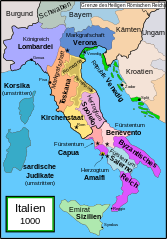
English: Political map of Italy in 1000 AD (CE). German translation of Image:Italy_1000_AD.svg which was created by MapMaster.
Part of a series of maps on the history of Italy:
|
| Kuupäev | 20. detsember 2007 (algne üleslaadimiskuupäev) |
| Allikas | Allikas masinloetaval kujul ära toomata. Oletatavalt üleslaadija oma töö (autoriõiguse ütluse järgi). |
| Autor | Autor masinloetaval kujul ära toomata. Oletatavalt Bamse (autoriõiguse ütluse järgi). |
| Teised versioonid |
[]
SVG:
PNG:
|


|
See fail sisaldab teksti, mida saab tõlkida sinu keelde, kasutades SVG- või tekstiredaktorit. Lisateavet leiad siit: SVG-failide tõlkimise kohta. |
References
[muuda]
- Bjorklund, Oddvar; Holmboe, Haakon; Rohr, Anders (1970) Historical Atlas of the World, Barnes & Noble, NY, SBN: 389-00253-4.
- This map from Allyn & Bacon, Longman, textbook publishers.
- This map of the w:en:Holy Roman Empire
- A map from Attilios
- This map of 1050 AD Italy, from the 1923 The Historical Atlas by William R. Shepherd
- This map of 1000 AD Italy from Fordham University, adapted from Muir's Historical Atlas, (1911).
In addition, a number of other sources were consulted in an effort to determine the following matters:
- The extent of Venetian control over the cities of Dalmatia such as Zara and Spalato. Although the Venetians had been pushed off the mainland earlier, in the period around the year 1000, the Venetians made an effort to recover these cities.
- The extent of Saracen control over Corsica and Sardinia. Information is sparse. The apparent situation is that the Muslims had several bases on the coasts of these islands, but did not control the countryside (such as they did in Sicily).
- Whether or not the principalities of Capua and Benevento were separate states in the year 1000. Based on lists of their rulers (various Pandulfs and Landulfs), the answer seems to be "yes".
- Who controlled the Balkans on the southeastern border of the Kingdom of Croatia. Candidates include Bulgaria, the Byzantine Empire, Croatia, and Serbia.
As noted, there is significant disagreement among sources on these questions.
This map was commissioned by Attilios, and there is also a discussion to be found on MapMaster's English talk page.
Litsents
[muuda]

|
Luba on antud selle dokumendi kopeerimiseks, avaldamiseks ja/või muutmiseks GNU Vaba Dokumentatsiooni Litsentsi versiooni 1.2 või hilisema Vaba Tarkvara Fondi avaldatud versiooni tingimuste alusel; muutumatute osadeta, esikaane tekstideta ja tagakaane tekstideta. Sellest loast on lisatud koopia leheküljel pealkirjaga "GNU Free Documentation License". |
| See fail kuulub jurisdiktsiooniga sidumata Creative Commonsi litsentsi "Autorile viitamine + jagamine samadel tingimustel 3.0" alla. | ||
| ||
| See litsentsimärgis lisati sellele failile GFDL-i litsentsimisuuenduse raames. |
Faili ajalugu
Klõpsa kuupäeva ja kellaaega, et näha sel ajahetkel kasutusel olnud failiversiooni.
| Kuupäev/kellaaeg | Pisipilt | Mõõtmed | Kasutaja | Kommentaar | |
|---|---|---|---|---|---|
| viimane | 11. aprill 2009, kell 16:36 | | 572 × 819 (334 KB) | Rhegion (arutelu | kaastöö) | aggiunta Reggio |
| 20. detsember 2007, kell 08:05 |  | 572 × 819 (332 KB) | Bamse (arutelu | kaastöö) | == Summary == '''de:''' Political map of Italy in 1000 AD (CE). German translation of Image:Italy_1000_AD.svg which was created by MapMaster. Part of a series of maps on the history of Italy: <gallery> Image:Italy and Illyria 1084 v2.svg|1084 AD Im |
Sa ei saa seda faili üle kirjutada.
Faili kasutus
Seda faili kasutavad järgmised 33 lehekülge:
- File:Italia 1000 AD-Ido.svg
- File:Italien 1000 AD.svg (failiümbersuunamine)
- File:Italy 1000 AD.svg
- File:Italy 1000 AD-it.svg
- File:Italy 1000 AD-de.svg
- File:Italy 1000 AD-es.svg
- File:Italy 1000 AD-pl.png
- File:Italy 1000 AD-fr.svg
- File:Italy 1000 AD-cs.svg
- File:Italy 1000 AD-hu.svg
- Template:Other versions/Italy 1000 AD
- File:Italy 1000 AD-he.svg
- File:Italy 1000 AD-ru.svg
- File:Italy 1000 AD-ar.svg
- File:Italy 1000 AD-el.png
- File:Italy 1000 AD-zh.svg
- File:Italy 1000 AD-zh.png
- File:Italia 1000 AD-Ido.svg
- File:Italy 1000 AD-ar.svg
- File:Italy 1000 AD-cs.svg
- File:Italy 1000 AD-de.svg
- File:Italy 1000 AD-el.png
- File:Italy 1000 AD-es.svg
- File:Italy 1000 AD-fr.svg
- File:Italy 1000 AD-he.svg
- File:Italy 1000 AD-hu.svg
- File:Italy 1000 AD-it.svg
- File:Italy 1000 AD-pl.png
- File:Italy 1000 AD-ru.svg
- File:Italy 1000 AD-zh.png
- File:Italy 1000 AD-zh.svg
- File:Italy 1000 AD.svg
- Template:Other versions/Italy 1000 AD
Globaalne failikasutus
Järgmised muud vikid kasutavad seda faili:
- Faili kasutus vikis da.wikipedia.org
- Faili kasutus vikis de.wikipedia.org
- 1011
- 1016
- 1018
- 1000
- Korsika
- Mark (Territorium)
- Etrurien
- Pietro II. Orseolo
- Herzogtum Benevent
- Herzogtum Spoleto
- Pietro II. Candiano
- Markgrafschaft Verona
- Pietro Orseolo
- Fürstentum Capua
- Pietro Badoer
- Vitale Candiano
- Tribuno Memmo
- Wikipedia:Kartenwerkstatt/Archiv/2007-12
- Herzogtum Amalfi
- Normannische Eroberung Süditaliens
- Katepanat Italien
- Abu l-Qasim (Emir)
- Hassan al-Kalbi
- Ottone Orseolo
- Pietro III. Candiano
- Pietro IV. Candiano
- Civita
- Nikephoros Phokas der Ältere
- Pandulf I.
- Italien-Runensteine
- Benutzer:Methodios/Boioannes
- Giovanni Orseolo
- Emirat von Sizilien
- Markgrafschaft Tuscien
- Waldrada (ductrix)
- Cesina
- Liste der historischen Staaten in Italien
- Maria (ductrix)
- Johanna (ductrix)
- Italienische Münzgeschichte
- Faili kasutus vikis de.wikibooks.org
- Faili kasutus vikis de.wikiversity.org
- Faili kasutus vikis eo.wikipedia.org
- Faili kasutus vikis nl.wikipedia.org
- Faili kasutus vikis uk.wikipedia.org