File:Italy 1000 AD-de.svg
Aller à la navigation
Aller à la recherche

Taille de cet aperçu PNG pour ce fichier SVG : 419 × 600 pixels. Autres résolutions : 167 × 240 pixels | 335 × 480 pixels | 536 × 768 pixels | 715 × 1 024 pixels | 1 430 × 2 048 pixels | 572 × 819 pixels.
Fichier d’origine (Fichier SVG, nominalement de 572 × 819 pixels, taille : 334 kio)
Légendes
Légendes
Ajoutez en une ligne la description de ce que représente ce fichier
Description[modifier]
| Description |
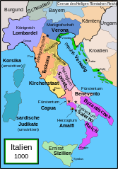
English: Political map of Italy in 1000 AD (CE). German translation of Image:Italy_1000_AD.svg which was created by MapMaster.
Part of a series of maps on the history of Italy:
|
| Date | 20 décembre 2007 (date de téléversement originale) |
| Source | La source n’a pas pu être reconnue automatiquement. « Travail personnel » supposé (étant donné la revendication de droit d’auteur). |
| Auteur | L’auteur n’a pas pu être identifié automatiquement. Il est supposé qu'il s'agit de : Bamse (étant donné la revendication de droit d’auteur). |
| Autres versions |
[]
SVG:
PNG:
|


|
Ce fichier SVG contient du texte encapsulé pouvant facilement être traduit dans votre langue en utilisant n'importe quel éditeur de fichier SVG ou de texte, ou par l'outil de traduction de fichiers SVG. Pour plus d'informations, voir : A propos de la traduction des fichiers SVG. |
References[modifier]
- Bjorklund, Oddvar; Holmboe, Haakon; Rohr, Anders (1970) Historical Atlas of the World, Barnes & Noble, NY, SBN: 389-00253-4.
- This map from Allyn & Bacon, Longman, textbook publishers.
- This map of the w:en:Holy Roman Empire
- A map from Attilios
- This map of 1050 AD Italy, from the 1923 The Historical Atlas by William R. Shepherd
- This map of 1000 AD Italy from Fordham University, adapted from Muir's Historical Atlas, (1911).
In addition, a number of other sources were consulted in an effort to determine the following matters:
- The extent of Venetian control over the cities of Dalmatia such as Zara and Spalato. Although the Venetians had been pushed off the mainland earlier, in the period around the year 1000, the Venetians made an effort to recover these cities.
- The extent of Saracen control over Corsica and Sardinia. Information is sparse. The apparent situation is that the Muslims had several bases on the coasts of these islands, but did not control the countryside (such as they did in Sicily).
- Whether or not the principalities of Capua and Benevento were separate states in the year 1000. Based on lists of their rulers (various Pandulfs and Landulfs), the answer seems to be "yes".
- Who controlled the Balkans on the southeastern border of the Kingdom of Croatia. Candidates include Bulgaria, the Byzantine Empire, Croatia, and Serbia.
As noted, there is significant disagreement among sources on these questions.
This map was commissioned by Attilios, and there is also a discussion to be found on MapMaster's English talk page.
Conditions d’utilisation[modifier]
Moi, en tant que détenteur des droits d’auteur sur cette œuvre, je la publie sous la licence suivante :

|
Vous avez la permission de copier, distribuer et modifier ce document selon les termes de la GNU Free Documentation License version 1.2 ou toute version ultérieure publiée par la Free Software Foundation, sans sections inaltérables, sans texte de première page de couverture et sans texte de dernière page de couverture. Un exemplaire de la licence est inclus dans la section intitulée GNU Free Documentation License. |
| Ce fichier est disponible selon les termes de la licence Creative Commons Attribution – Partage dans les Mêmes Conditions 3.0 (non transposée). | ||
| ||
| Ce bandeau de licence a été ajouté à ce fichier dans le cadre de la procédure de mise à jour des licences des images sous GFDL. |
Historique du fichier
Cliquer sur une date et heure pour voir le fichier tel qu'il était à ce moment-là.
| Date et heure | Vignette | Dimensions | Utilisateur | Commentaire | |
|---|---|---|---|---|---|
| actuel | 11 avril 2009 à 16:36 | | 572 × 819 (334 kio) | Rhegion (d | contributions) | aggiunta Reggio |
| 20 décembre 2007 à 08:05 |  | 572 × 819 (332 kio) | Bamse (d | contributions) | == Summary == '''de:''' Political map of Italy in 1000 AD (CE). German translation of Image:Italy_1000_AD.svg which was created by MapMaster. Part of a series of maps on the history of Italy: <gallery> Image:Italy and Illyria 1084 v2.svg|1084 AD Im |
Vous ne pouvez pas remplacer ce fichier.
Utilisations locales du fichier
Les 33 pages suivantes utilisent ce fichier :
- File:Italia 1000 AD-Ido.svg
- File:Italien 1000 AD.svg (redirection de fichier)
- File:Italy 1000 AD.svg
- File:Italy 1000 AD-it.svg
- File:Italy 1000 AD-de.svg
- File:Italy 1000 AD-es.svg
- File:Italy 1000 AD-pl.png
- File:Italy 1000 AD-fr.svg
- File:Italy 1000 AD-cs.svg
- File:Italy 1000 AD-hu.svg
- Template:Other versions/Italy 1000 AD
- File:Italy 1000 AD-he.svg
- File:Italy 1000 AD-ru.svg
- File:Italy 1000 AD-ar.svg
- File:Italy 1000 AD-el.png
- File:Italy 1000 AD-zh.svg
- File:Italy 1000 AD-zh.png
- File:Italia 1000 AD-Ido.svg
- File:Italy 1000 AD-ar.svg
- File:Italy 1000 AD-cs.svg
- File:Italy 1000 AD-de.svg
- File:Italy 1000 AD-el.png
- File:Italy 1000 AD-es.svg
- File:Italy 1000 AD-fr.svg
- File:Italy 1000 AD-he.svg
- File:Italy 1000 AD-hu.svg
- File:Italy 1000 AD-it.svg
- File:Italy 1000 AD-pl.png
- File:Italy 1000 AD-ru.svg
- File:Italy 1000 AD-zh.png
- File:Italy 1000 AD-zh.svg
- File:Italy 1000 AD.svg
- Template:Other versions/Italy 1000 AD
Utilisations du fichier sur d’autres wikis
Les autres wikis suivants utilisent ce fichier :
- Utilisation sur da.wikipedia.org
- Utilisation sur de.wikipedia.org
- 1011
- 1016
- 1018
- 1000
- Korsika
- Mark (Territorium)
- Etrurien
- Pietro II. Orseolo
- Herzogtum Benevent
- Herzogtum Spoleto
- Pietro II. Candiano
- Markgrafschaft Verona
- Pietro Orseolo
- Fürstentum Capua
- Pietro Badoer
- Vitale Candiano
- Tribuno Memmo
- Wikipedia:Kartenwerkstatt/Archiv/2007-12
- Herzogtum Amalfi
- Normannische Eroberung Süditaliens
- Katepanat Italien
- Abu l-Qasim (Emir)
- Hassan al-Kalbi
- Ottone Orseolo
- Pietro III. Candiano
- Pietro IV. Candiano
- Civita
- Nikephoros Phokas der Ältere
- Pandulf I.
- Italien-Runensteine
- Benutzer:Methodios/Boioannes
- Giovanni Orseolo
- Emirat von Sizilien
- Markgrafschaft Tuscien
- Waldrada (ductrix)
- Cesina
- Liste der historischen Staaten in Italien
- Maria (ductrix)
- Johanna (ductrix)
- Italienische Münzgeschichte
- Utilisation sur de.wikibooks.org
- Utilisation sur de.wikiversity.org
- Utilisation sur eo.wikipedia.org
- Utilisation sur nl.wikipedia.org
- Utilisation sur uk.wikipedia.org