File:Italy and Illyria 1084 AD-ru.svg
Pāriet uz navigāciju
Pāriet uz meklēšanu

Size of this PNG preview of this SVG file: 480 × 600 pikseļi. Citi izmēri: 192 × 240 pikseļi | 384 × 480 pikseļi | 614 × 768 pikseļi | 819 × 1 024 pikseļi | 1 638 × 2 048 pikseļi | 588 × 735 pikseļi.
Sākotnējais fails (SVG fails, definētais izmērs 588 × 735 pikseļi, faila izmērs: 252 KB)
Captions
Captions
Pievieno vienas rindiņas aprakstu, ko šis fails attēlo
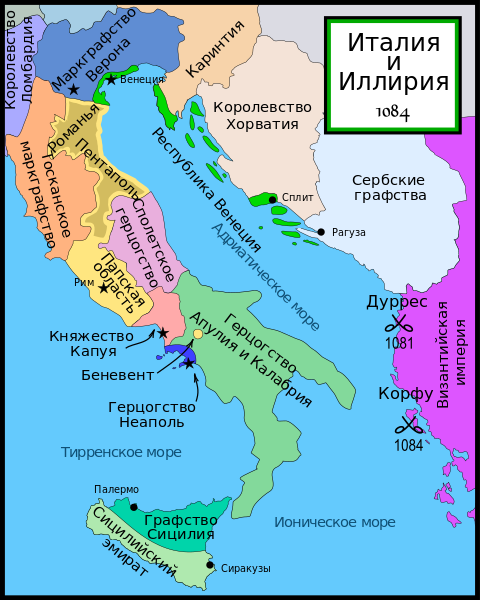
| Apraksts | Map of Italy and the Illyrian coast in the year 1084. |
| Datums | (UTC) |
| Avots | |
| Autors | |
| Citas versijas |
[]
Part of a series of maps on the history of Italy:
|


| This is a retouched picture, which means that it has been digitally altered from its original version. Modifications: Rusiphication.. The original can be viewed here: Italy and Illyria 1084 v2.svg:
|
MapMaster, šī darba autortiesību īpašnieks, publicē to saskaņā ar šo licenci:
Šis fails tiek izplatīts saskaņā ar licences Creative Commons Atsauce-Līdzīgi Noteikumi 2.5 Vispārējiem noteikumiem.
Atsauce: MapMaster
- Jūs varat brīvi:
- koplietot – kopēt, izplatīt un pārraidīt darbu
- remiksēt – pielāgot darbu
- Saskaņā ar šādiem nosacījumiem:
- atsaucoties – Tev ir jānorāda autors, saite uz licenci un to, vai veiktas kādas izmaiņas. To var darīt jebkādā saprātīgā veidā, bet ne tādā, kas norādītu, ka licencētājs atbalsta tevi vai veidu, kā tu izmanto šo darbu.
- nemainot licenci – Ja tu miksē, pārveido vai izmanto materiālu, tev savs devums jāpublicē ar to pašu vai saderīgu licenci kā oriģināls.
References[labot šo sadaļu]
- This map from Allyn & Bacon, Longman, textbook publishers.
- Bjorklund, Oddvar; Holmboe, Haakon; Rohr, Anders (1970) Historical Atlas of the World, Barnes & Noble, NY, SBN: 389-00253-4.
- Hammond Atlas Corporation (2007) Hammond Historical World Atlas.
- Matthew, Donald (1989) Atlas of Medieval Europe, Time-Life Books.
- This map of 1000 AD Italy from Fordham University, adapted from Muir's Historical Atlas, (1911).
- This map of 1050 AD Italy, from the 1923 The Historical Atlas by William R. Shepherd
- This Wikipedia map of the w:en:Holy Roman Empire
Original upload log[labot šo sadaļu]
This image is a derivative work of the following images:
- File:Italy_and_Illyria_1084_v2.svg licensed with Cc-by-sa-2.5
- 2007-07-29T12:20:43Z Lokal Profil 588x735 (659776 Bytes) Cleaned up code (specifically loads of empty groups)
- 2007-04-15T05:43:43Z MapMaster 588x735 (711771 Bytes) Minor changes
- 2007-02-13T03:56:13Z MapMaster 588x735 (710980 Bytes) Map of Italy and the Illyrian coast in the year 1084
Uploaded with derivativeFX
Faila hronoloģija
Uzklikšķini uz datums/laiks kolonnā esošās saites, lai apskatītos, kā šis fails izskatījās tad.
| Datums/Laiks | Attēls | Izmēri | Dalībnieks | Komentārs | |
|---|---|---|---|---|---|
| tagadējais | 2009. gada 27. maijs, plkst. 14.33 | | 588 × 735 (252 KB) | Ahnode (diskusija | devums) | {{Information |Description=Map of Italy and the Illyrian coast in the year 1084. Part of a series of maps on the history of Italy: <gallery> Image:Italy 1000 AD.svg|1000 AD Image:Italy 1494 v2.png|1494 AD Image:Italy 1796.png|1796 AD Image:Italy c 1810.p |
Šo failu nevar pārrakstīt.
Faila lietojums
Šo failu izmanto šajās 27 lapās:
- File:Italy and Illyria 1084 AD-ca.svg
- File:Italy and Illyria 1084 AD-cs.svg
- File:Italy and Illyria 1084 AD-es.svg
- File:Italy and Illyria 1084 AD-fr.svg
- File:Italy and Illyria 1084 AD-hu.svg
- File:Italy and Illyria 1084 AD-it.svg
- File:Italy and Illyria 1084 AD-ru.svg
- File:Italy and Illyria 1084 AD-sv.png
- File:Italy and Illyria 1084 AD-vi.svg
- File:Italy and Illyria 1084 AD-zh.png
- File:Italy and Illyria 1084 AD-zh.svg
- File:Italy and Illyria 1084 AD.svg
- File:Italy and Illyria 1084 v2 ru.svg (faila pāradresācija)
- File:Italy and Illyria 1084 AD.svg
- File:Italy and Illyria 1084 AD-sv.png
- File:Italy and Illyria 1084 AD-cs.svg
- File:Italy and Illyria 1084 AD-it.svg
- File:Italy and Illyria 1084 AD-ru.svg
- File:Italy and Illyria 1084 AD-fr.svg
- File:Italy and Illyria 1084 AD-hu.svg
- Template:Other versions/Italy and Illyria 1084 AD
- File:Italy and Illyria 1084 AD-zh.svg
- File:Italy and Illyria 1084 AD-zh.png
- File:Italy and Illyria 1084 AD-vi.svg
- File:Italy and Illyria 1084 AD-es.svg
- File:Italy and Illyria 1084 AD-ca.svg
- Template:Other versions/Italy and Illyria 1084 AD
Globālais faila lietojums
Šīs Vikipēdijas izmanto šo failu:
- Izmantojums be.wikipedia.org
- Izmantojums ru.wikipedia.org
- Генрих IV (император Священной Римской империи)
- Роберт Гвискар
- Алексей I Комнин
- Боэмунд I (князь Антиохии)
- Участник:Samvlamix
- Княжество Капуя
- Сицилийский эмират
- Проект:Графическая мастерская/Заявки/Архив/2009/05
- Битва при Диррахии (1081)
- Нормандское завоевание Южной Италии
- Ландульф VI (князь Беневенто)
- Участник:Удивленный1/Вспомогательная
- Izmantojums uz.wikipedia.org