File:JMA Surface Analysis Chart 01-03-2017 06Z.png
Original file (3,004 × 2,097 pixels, file size: 2.13 MB, MIME type: image/png)
Captions
Captions
Summary
[edit]| Description |
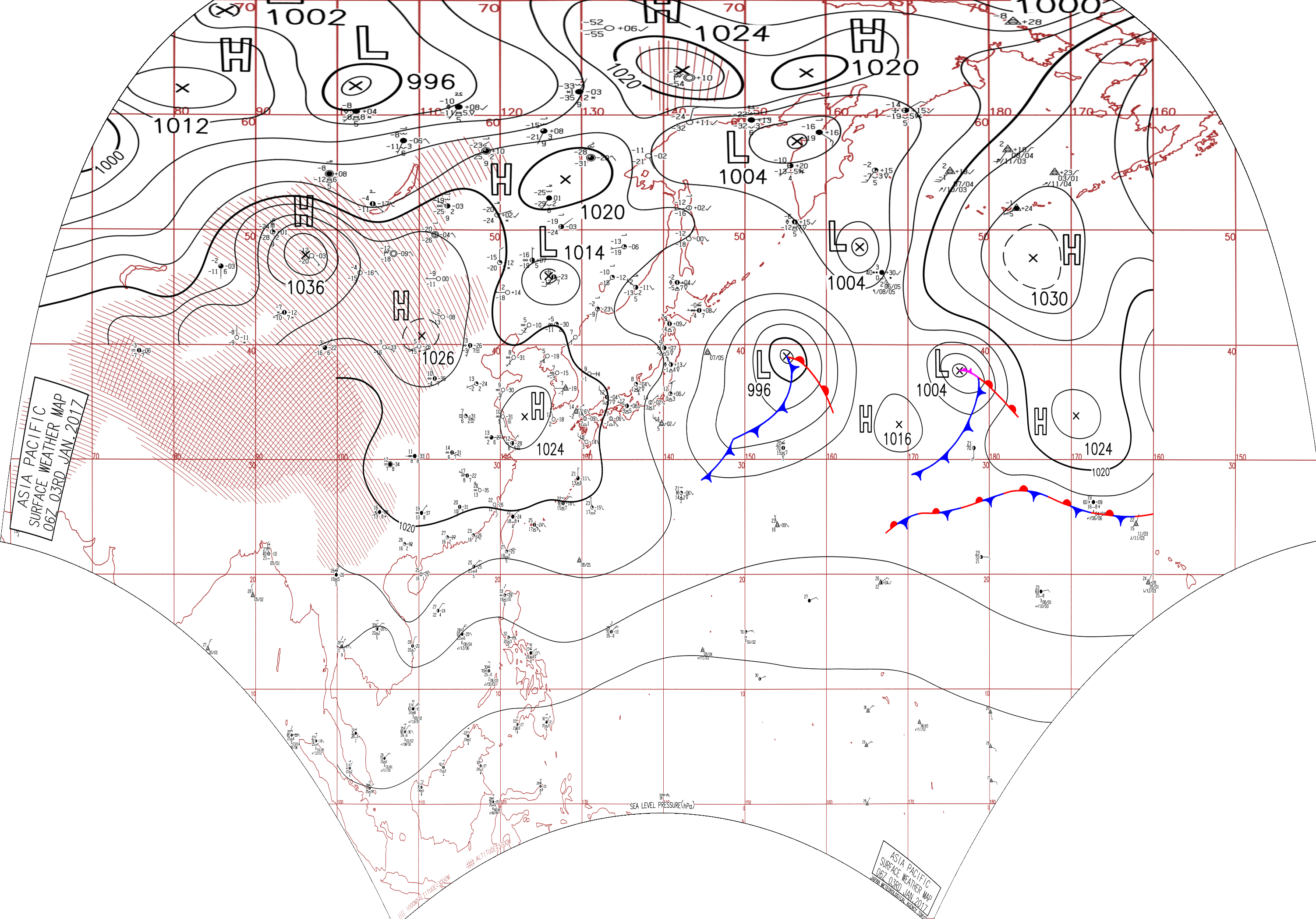
English: Surface analysis chart of Metarea XI for 3 January 2017, 06Z. Product of the Japan Meteorological Agency.
WWJP25 RJTD 030600 WARNING AND SUMMARY 030600. WARNING VALID 040600. WARNING IS UPDATED EVERY 6 HOURS. GALE WARNING. DEVELOPING LOW 996 HPA AT 39N 155E FAR OFF EAST OF JAPAN MOVING EASTNORTHEAST 25 KNOTS. WARM FRONT FROM 39N 155E TO 37N 158E 34N 160E. COLD FRONT FROM 39N 155E TO 37N 156E 34N 153E 32N 149E 30N 147E 29N 144E. WINDS 30 TO 40 KNOTS WITHIN 700 MILES OF LOW SOUTH SEMICIRCLE AND 400 MILES ELSEWHERE. GALE WARNING. DEVELOPING LOW 1004 HPA AT 38N 176E SEA SOUTH OF ALEUTIANS MOVING NORTHEAST 20 KNOTS. OCCLUDED FRONT FROM 38N 176E TO 38N 177E 37N 179E. WARM FRONT FROM 37N 179E TO 35N 178W 34N 176W. COLD FRONT FROM 37N 179E TO 34N 178E 30N 174E 28N 169E. WINDS 30 TO 40 KNOTS WITHIN 400 MILES OF LOW SOUTHEAST SEMICIRCLE AND 300 MILES ELSEWHERE. GALE WARNING. DEVELOPING LOW 1004 HPA AT 49N 164E SEA EAST OF KURILS MOVING NORTHNORTHEAST 25 KNOTS. WINDS 30 TO 35 KNOTS WITHIN 300 MILES OF LOW. WARNING. DENSE FOG OBSERVED LOCALLY OVER BOHAI YELLOW SEA EAST CHINA SEA. WARNING. DENSE FOG OBSERVED LOCALLY OVER WATERS BOUNDED BY 45N 158E 49N 162E 47N 172E 46N 180E 38N 180E 38N 165E 45N 158E. SUMMARY. LOW 1004 HPA AT 58N 156E EAST SLOWLY. HIGH 1024 HPA AT 34N 123E ESE SLOWLY. HIGH 1016 HPA AT 32N 169E EAST 20 KT. STATIONARY FRONT FROM 25N 175E TO 26N 178E 27N 180E.
|
| Date | |
| Source | Japan Meteorological Agency weather chart page |
| Author | Based on "Surface Analysis Chart" (Japan Meteorological Agency) |
Licensing
[edit]This image was produced by the Japan Meteorological Agency. The legal notice (archive) stated that all the images published on their website is compatible with the Creative Commons Attribution 4.0 License, which means that all the images on this website is published under the Creative Commons Attribution 4.0 License unless otherwise specified.
This file is licensed under the Creative Commons Attribution 4.0 International license. Attribution: Japan Meteorological Agency
|
 |

File history
Click on a date/time to view the file as it appeared at that time.
| Date/Time | Thumbnail | Dimensions | User | Comment | |
|---|---|---|---|---|---|
| current | 07:24, 24 August 2017 | | 3,004 × 2,097 (2.13 MB) | Supportstorm (talk | contribs) | Reanalysis |
| 05:16, 9 August 2017 |  | 2,500 × 1,614 (2.09 MB) | Supportstorm (talk | contribs) | =={{int:filedesc}}== {{Information |description={{en|1=Surface analysis chart of Metarea XI for 3 January 2017, 06Z. Product of the Japan Meteorological Agency.}} WWJP25 RJTD 030600 WARNING AND SUMMARY 030600. WARNING VALID 040600. WARNING IS UPDATE... |
You cannot overwrite this file.
File usage on Commons
There are no pages that use this file.