File:JMA Surface Analysis Chart 01-22-2017 00Z.png
Original file (3,004 × 2,097 pixels, file size: 2.22 MB, MIME type: image/png)
Captions
Captions
Summary[edit]
| Description |
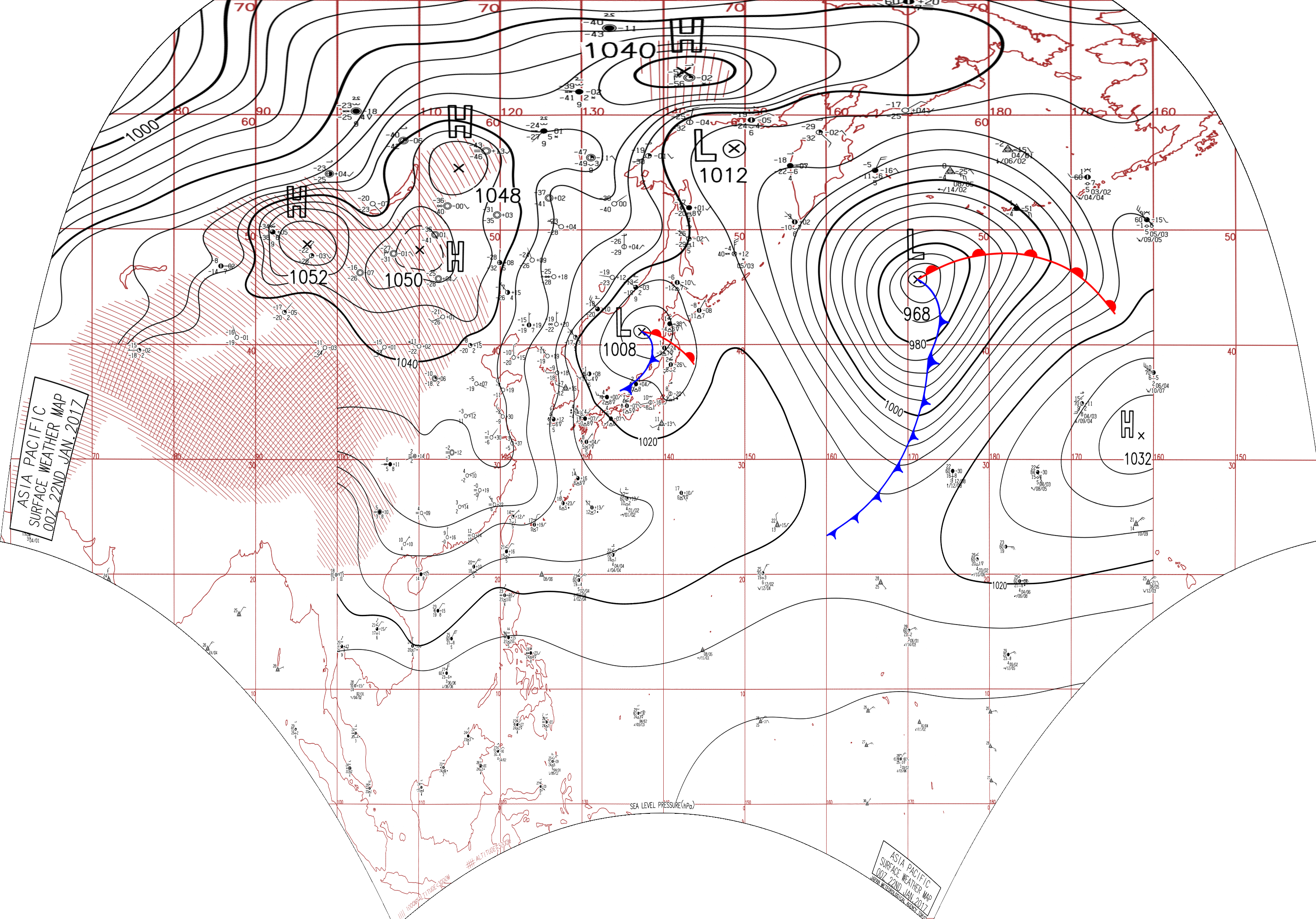
English: Surface analysis chart of Metarea XI for 22 January 2017, 00Z. Product of the Japan Meteorological Agency.
WWJP25 RJTD 220000 WARNING AND SUMMARY 220000. WARNING VALID 230000. WARNING IS UPDATED EVERY 6 HOURS. STORM WARNING. DEVELOPING LOW 968 HPA AT 46N 171E SEA SOUTH OF ALEUTIANS MOVING NORTHEAST 40 KNOTS. WARM FRONT FROM 46N 171E TO 48N 178E 47N 172W 43N 165W. COLD FRONT FROM 46N 171E TO 41N 173E 37N 171E 32N 169E 26N 163E 23N 157E. WINDS 30 TO 50 KNOTS WITHIN 1200 MILES OF LOW SOUTH SEMICIRCLE AND 700 MILES ELSEWHERE. FORECAST POSITION FOR 221200UTC AT 51N 177E WITH UNCERTAINTY OF 85 MILES RADIUS. FORECAST POSITION FOR 230000UTC AT 50N 178W WITH UNCERTAINTY OF 130 MILES RADIUS. GALE WARNING. DEVELOPING LOW 1008 HPA AT 41N 137E SEA OF JAPAN MOVING EASTNORTHEAST 20 KNOTS. WARM FRONT FROM 41N 137E TO 40N 140E 38N 142E. COLD FRONT FROM 41N 137E TO 39N 137E 36N 135E 34N 131E. WINDS 30 TO 35 KNOTS WITHIN 900 MILES OF LOW SOUTH SEMICIRCLE AND 500 MILES ELSEWHERE. GALE WARNING. EXPECTED NORTHERLY TO NORTHEASTERLY WINDS 30 TO 35 KNOTS PREVAILING OVER WATERS BOUNDED BY 26N 120E 17N 128E 17N 119E 09N 110E 06N 105E 08N 104E 12N 109E 21N 113E 26N 120E FOR NEXT 12 HOURS. WARNING. DENSE FOG OBSERVED LOCALLY OVER WATERS BOUNDED BY 43N 168E 51N 176E 52N 180E 42N 180E 41N 175E 43N 168E. SUMMARY. LOW 1012 HPA AT 57N 149E ALMOST STATIONARY.
|
| Date | |
| Source | Japan Meteorological Agency weather chart page |
| Author | Based on "Surface Analysis Chart" (Japan Meteorological Agency) |
Licensing[edit]
This image was produced by the Japan Meteorological Agency. The legal notice (archive) stated that all the images published on their website is compatible with the Creative Commons Attribution 4.0 License, which means that all the images on this website is published under the Creative Commons Attribution 4.0 License unless otherwise specified.
This file is licensed under the Creative Commons Attribution 4.0 International license. Attribution: Japan Meteorological Agency
|
 |

File history
Click on a date/time to view the file as it appeared at that time.
| Date/Time | Thumbnail | Dimensions | User | Comment | |
|---|---|---|---|---|---|
| current | 23:36, 2 September 2017 | | 3,004 × 2,097 (2.22 MB) | Supportstorm (talk | contribs) | Reanalysis |
| 02:08, 11 August 2017 |  | 2,500 × 1,614 (2.19 MB) | Supportstorm (talk | contribs) | =={{int:filedesc}}== {{Information |description={{en|1=Surface analysis chart of Metarea XI for 22 January 2017, 00Z. Product of the Japan Meteorological Agency.}} WWJP25 RJTD 220000 WARNING AND SUMMARY 220000. WARNING VALID 230000. WARNING IS UPDAT... |
You cannot overwrite this file.
File usage on Commons
There are no pages that use this file.