File:JMA Surface Analysis Chart 08-01-2017 06Z.png
Original file (2,500 × 1,614 pixels, file size: 2.01 MB, MIME type: image/png)
Captions
Captions
Summary
[edit]| Description |
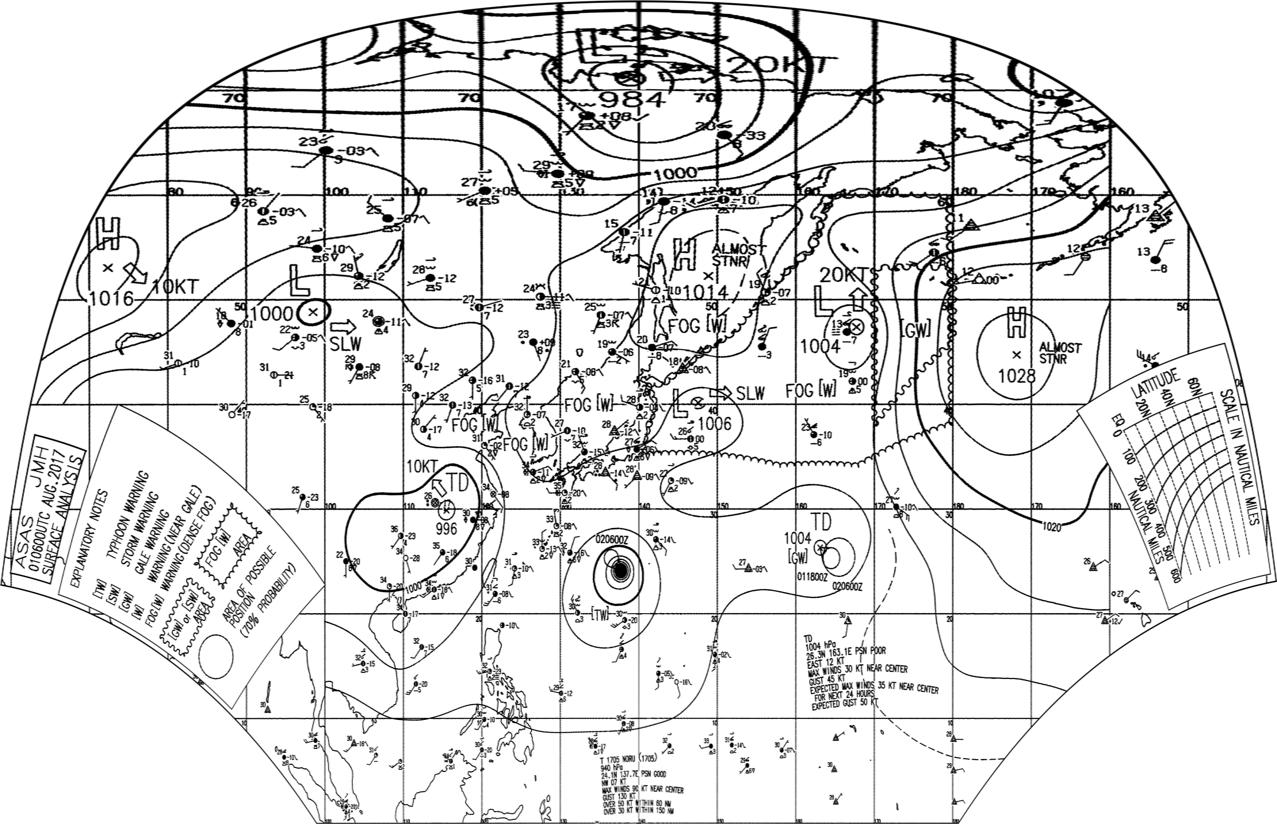
English: Surface analysis chart of Metarea XI for 1 August 2017, 06Z. Product of the Japan Meteorological Agency.
WWJP25 RJTD 010600 WARNING AND SUMMARY 010600. WARNING VALID 020600. WARNING IS UPDATED EVERY 6 HOURS. GALE WARNING. SOUTHERLY TO SOUTHEASTERLY WINDS 30 TO 35 KNOTS PREVAILING OVER WATERS BOUNDED BY 38N 170E 53N 170E 53N 180E 46N 180E 38N 170E. GALE WARNING. TROPICAL DEPRESSION 1004 HPA AT 26.3N 163.1E SEA AROUND OF WAKE MOVING EAST 12 KNOTS. POSITION POOR. MAX WINDS 30 KNOTS NEAR CENTER. EXPECTED MAX WINDS 35 KNOTS NEAR CENTER FOR NEXT 24 HOURS. FORECAST POSITION FOR 011800UTC AT 25.3N 164.5E WITH 60 MILES RADIUS OF 70 PERCENT PROBABILITY CIRCLE. FORECAST POSITION FOR 020600UTC AT 25.4N 165.5E WITH 110 MILES RADIUS OF 70 PERCENT PROBABILITY CIRCLE. WARNING. DENSE FOG OBSERVED LOCALLY OVER SEA OF OKHOTSK SEA OF JAPAN BOHAI YELLOW SEA. WARNING. DENSE FOG OBSERVED LOCALLY OVER WATERS BOUNDED BY 35N 140E 40N 142E 42N 141E 42N 143E 47N 152E 55N 162E 60N 164E 60N 180E 38N 180E 34N 168E 34N 158E 35N 140E. SUMMARY. LOW 1006 HPA AT 40N 148E EAST SLOWLY. LOW 1004 HPA AT 47N 168E NORTH 20 KT. HIGH 1014 HPA AT 52N 149E ALMOST STATIONARY. REMARKS. TYPHOON 1705 NORU (1705) 940 HPA AT 24.1N 137.7E : SEE TROPICAL CYCLONE WARNING.
|
| Date | |
| Source | Japan Meteorological Agency weather chart page |
| Author | Based on "Surface Analysis Chart" (Japan Meteorological Agency) |
Licensing
[edit]This image was produced by the Japan Meteorological Agency. The legal notice (archive) stated that all the images published on their website is compatible with the Creative Commons Attribution 4.0 License, which means that all the images on this website is published under the Creative Commons Attribution 4.0 License unless otherwise specified.
This file is licensed under the Creative Commons Attribution 4.0 International license. Attribution: Japan Meteorological Agency
|
 |

| Annotations | This image is annotated: View the annotations at Commons |
File history
Click on a date/time to view the file as it appeared at that time.
| Date/Time | Thumbnail | Dimensions | User | Comment | |
|---|---|---|---|---|---|
| current | 20:04, 2 August 2017 | | 2,500 × 1,614 (2.01 MB) | Supportstorm (talk | contribs) | =={{int:filedesc}}== {{Information |description={{en|1=Surface analysis chart of Metarea XI for 1 August 2017, 06Z. Product of the Japan Meteorological Agency.}} |date=2017-08-01 |source=[http://www.jma.go.jp/en/g3/ Japan Meteorological Agency weather... |
You cannot overwrite this file.
File usage on Commons
There are no pages that use this file.