File:JMA Surface Analysis Chart 08-04-2017 12Z.png

Original file (2,500 × 1,614 pixels, file size: 2 MB, MIME type: image/png)
Captions
Captions
Summary
[edit]| Description |
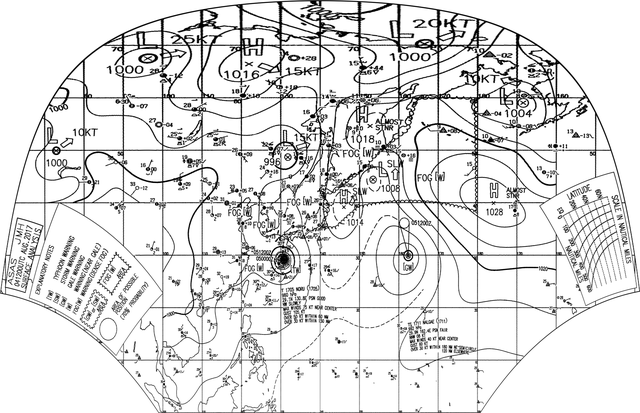
English: Surface analysis chart of Metarea XI for 4 August 2017, 12Z. Product of the Japan Meteorological Agency.
WWJP25 RJTD 041200 WARNING AND SUMMARY 041200. WARNING VALID 051200. WARNING IS UPDATED EVERY 6 HOURS. WARNING. DENSE FOG OBSERVED LOCALLY OVER SEA OF OKHOTSK SEA OF JAPAN BOHAI YELLOW SEA EAST CHINA SEA. WARNING. DENSE FOG OBSERVED LOCALLY OVER WATERS BOUNDED BY 35N 140E 39N 142E 42N 140E 42N 143E 46N 150E 54N 162E 60N 164E 60N 180E 38N 180E 39N 150E 35N 144E 35N 140E. SUMMARY. LOW 1008 HPA AT 44N 153E NORTH SLOWLY. HIGH 1014 HPA AT 39N 146E NNE SLOWLY. HIGH 1018 HPA AT 55N 153E ALMOST STATIONARY. REMARKS. TYPHOON 1705 NORU (1705) 960 HPA AT 29.1N 130.8E : SEE TROPICAL CYCLONE WARNING. TROPICAL STORM 1711 NALGAE (1711) 992 HPA AT 29.9N 162.4E : SEE TROPICAL CYCLONE WARNING.
|
| Date | |
| Source | Japan Meteorological Agency weather chart page |
| Author | Based on "Surface Analysis Chart" (Japan Meteorological Agency) |
Licensing
[edit]This image was produced by the Japan Meteorological Agency. The legal notice (archive) stated that all the images published on their website is compatible with the Creative Commons Attribution 4.0 License, which means that all the images on this website is published under the Creative Commons Attribution 4.0 License unless otherwise specified.
This file is licensed under the Creative Commons Attribution 4.0 International license. Attribution: Japan Meteorological Agency
|
 |

| Annotations | This image is annotated: View the annotations at Commons |
File history
Click on a date/time to view the file as it appeared at that time.
| Date/Time | Thumbnail | Dimensions | User | Comment | |
|---|---|---|---|---|---|
| current | 19:11, 4 August 2017 | | 2,500 × 1,614 (2 MB) | Supportstorm (talk | contribs) | =={{int:filedesc}}== {{Information |description={{en|1=Surface analysis chart of Metarea XI for 4 August 2017, 12Z. Product of the Japan Meteorological Agency.}} WWJP25 RJTD 041200 WARNING AND SUMMARY 041200. WARNING VALID 051200. WARNING IS UPDATED... |
You cannot overwrite this file.
File usage on Commons
There are no pages that use this file.