File:JMA Surface Analysis Chart 08-05-2017 18Z.png

Original file (2,500 × 1,614 pixels, file size: 1.95 MB, MIME type: image/png)
Captions
Captions
Summary
[edit]| Description |
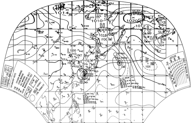
English: Surface analysis chart of Metarea XI for 5 August 2017, 18Z. Product of the Japan Meteorological Agency.
WWJP25 RJTD 051800 WARNING AND SUMMARY 051800. WARNING VALID 061800. WARNING IS UPDATED EVERY 6 HOURS. WARNING. DENSE FOG OBSERVED LOCALLY OVER SEA OF OKHOTSK SEA OF JAPAN BOHAI YELLOW SEA. WARNING. DENSE FOG OBSERVED LOCALLY OVER WATERS BOUNDED BY 35N 140E 40N 142E 43N 141E 44N 146E 51N 158E 60N 164E 60N 180E 40N 180E 38N 168E 38N 152E 35N 144E 35N 140E. SUMMARY. HIGH 1016 HPA AT 58N 147E ALMOST STATIONARY. REMARKS. TYPHOON 1705 NORU (1705) 970 HPA AT 30.3N 130.5E : SEE TROPICAL CYCLONE WARNING. TROPICAL STORM 1711 NALGAE (1711) 990 HPA AT 38.2N 160.4E : SEE TROPICAL CYCLONE WARNING.
|
| Date | |
| Source | Japan Meteorological Agency weather chart page |
| Author | Based on "Surface Analysis Chart" (Japan Meteorological Agency) |
Licensing
[edit]This image was produced by the Japan Meteorological Agency. The legal notice (archive) stated that all the images published on their website is compatible with the Creative Commons Attribution 4.0 License, which means that all the images on this website is published under the Creative Commons Attribution 4.0 License unless otherwise specified.
This file is licensed under the Creative Commons Attribution 4.0 International license. Attribution: Japan Meteorological Agency
|
 |

| Annotations | This image is annotated: View the annotations at Commons |
File history
Click on a date/time to view the file as it appeared at that time.
| Date/Time | Thumbnail | Dimensions | User | Comment | |
|---|---|---|---|---|---|
| current | 21:41, 5 August 2017 | | 2,500 × 1,614 (1.95 MB) | Supportstorm (talk | contribs) | =={{int:filedesc}}== {{Information |description={{en|1=Surface analysis chart of Metarea XI for 5 August 2017, 18Z. Product of the Japan Meteorological Agency.}} WWJP25 RJTD 051800 WARNING AND SUMMARY 051800. WARNING VALID 061800. WARNING IS UPDATED... |
You cannot overwrite this file.
File usage on Commons
There are no pages that use this file.