File:JMA Surface Analysis Chart 08-23-2017 12Z.png

Original file (2,500 × 1,614 pixels, file size: 1.95 MB, MIME type: image/png)
Captions
Captions
Summary[edit]
| Description |
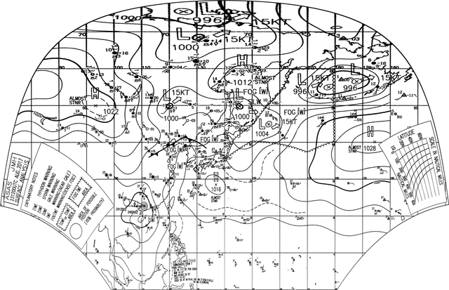
English: Surface analysis chart of Metarea XI for 23 August 2017, 12Z. Product of the Japan Meteorological Agency.
WWJP25 RJTD 231200 WARNING AND SUMMARY 231200. WARNING VALID 241200. WARNING IS UPDATED EVERY 6 HOURS. WARNING. DENSE FOG OBSERVED LOCALLY OVER SEA OF OKHOTSK SEA OF JAPAN BOHAI YELLOW SEA. WARNING. DENSE FOG OBSERVED LOCALLY OVER WATERS BOUNDED BY 35N 140E 41N 143E 45N 150E 54N 160E 60N 164E 60N 180E 40N 180E 37N 170E 40N 150E 35N 140E. SUMMARY. LOW 1000 HPA AT 50N 145E EAST SLOWLY. LOW 1004 HPA AT 45N 156E ENE 15 KT. LOW 996 HPA AT 55N 178E ENE 15 KT. HIGH 1016 HPA AT 28N 137E ALMOST STATIONARY. HIGH 1012 HPA AT 58N 146E ALMOST STATIONARY. STATIONARY FRONT FROM 36N 113E TO 39N 119E 41N 125E 40N 130E 38N 133E. REMARKS. SEVERE TROPICAL STORM 1713 HATO (1713) 985 HPA AT 22.7N 111.0E : SEE TROPICAL CYCLONE WARNING.
|
| Date | |
| Source | Japan Meteorological Agency weather chart page |
| Author | Based on "Surface Analysis Chart" (Japan Meteorological Agency) |
Licensing[edit]
This image was produced by the Japan Meteorological Agency. The legal notice (archive) stated that all the images published on their website is compatible with the Creative Commons Attribution 4.0 License, which means that all the images on this website is published under the Creative Commons Attribution 4.0 License unless otherwise specified.
This file is licensed under the Creative Commons Attribution 4.0 International license. Attribution: Japan Meteorological Agency
|
 |

File history
Click on a date/time to view the file as it appeared at that time.
| Date/Time | Thumbnail | Dimensions | User | Comment | |
|---|---|---|---|---|---|
| current | 21:37, 23 August 2017 | | 2,500 × 1,614 (1.95 MB) | Supportstorm (talk | contribs) | =={{int:filedesc}}== {{Information |description={{en|1=Surface analysis chart of Metarea XI for 23 August 2017, 12Z. Product of the Japan Meteorological Agency.}} WWJP25 RJTD 231200 WARNING AND SUMMARY 231200. WARNING VALID 241200. WARNING IS UPDATE... |
You cannot overwrite this file.
File usage on Commons
There are no pages that use this file.
File usage on other wikis
The following other wikis use this file:
- Usage on ja.wikipedia.org