File:Jabłonna (gmina w województwie lubelskim) location map.png

Original file (1,211 × 1,004 pixels, file size: 335 KB, MIME type: image/png)
Captions
Captions
Summary
[edit]_location_map.png&action=edit§ion=1)
| Description |
English: Location map |
| Date | |
| Source | Own work |
| Author | Smat |
| Description |
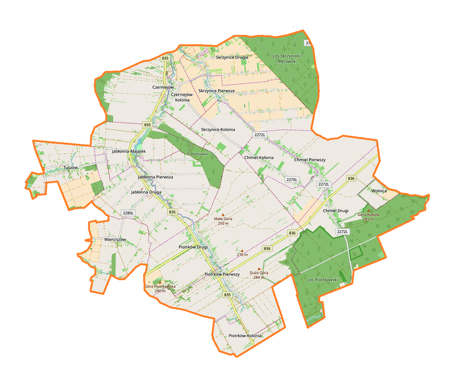
Polski: Mapa gminy Jabłonna, Polska
English: Map of Jabłonna (gmina w województwie lubelskim), Poland |
|||||||||
| Date | ||||||||||
| Source | You may find a page on the OpenStreetMap wiki page for Jabłonna (gmina w województwie lubelskim) | |||||||||
| Creator |
OpenStreetMap contributors OpenStreetMap contributors |
|||||||||
| Permission (Reusing this file) |
OpenStreetMap data is available under the Open Database License (details). Map tiles are licensed under the Creative Commons Attribution-ShareAlike 2.0 license (CC-BY-SA 2.0).
This file is licensed under the Creative Commons Attribution-Share Alike 2.0 Generic license.
|
|||||||||
| Geotemporal data | ||||||||||
| Bounding box |
|
|||||||||
| Georeferencing | If inappropriate please set warp_status = skip to hide. | |||||||||
Licensing
[edit]_location_map.png&action=edit§ion=2)
| This work contains information from OpenStreetMap, which is made available under the Open Database License (ODbL).
The ODbL does not require any particular license for maps produced from ODbL data. Prior to 1 August 2020, map tiles produced by the OpenStreetMap Foundation were licensed under the CC-BY-SA-2.0 license. Maps produced by other people may be subject to other licences. |
File history
Click on a date/time to view the file as it appeared at that time.
| Date/Time | Thumbnail | Dimensions | User | Comment | |
|---|---|---|---|---|---|
| current | 18:28, 18 September 2017 | | 1,211 × 1,004 (335 KB) | Smat (talk | contribs) | User created page with UploadWizard |
You cannot overwrite this file.
File usage on Commons
There are no pages that use this file.
File usage on other wikis
The following other wikis use this file:
- Usage on pl.wikipedia.org
- Rezerwat przyrody Chmiel
- Rezerwat przyrody Olszanka (woj. lubelskie)
- Jabłonna (gmina w województwie lubelskim)
- Chmiel Pierwszy
- Czerniejów-Kolonia
- Jabłonna Pierwsza
- Piotrków Pierwszy
- Skrzynice Pierwsze
- Tuszów
- Wierciszów
- Wolnica (województwo lubelskie)
- Czerniejów (powiat lubelski)
- Chmiel-Kolonia
- Chmiel Drugi
- Piotrków Drugi
- Skrzynice-Kolonia
- Skrzynice Drugie
- Jabłonna Druga
- Jabłonna-Majątek
- Piotrków-Kolonia
- ER Piotrków
- Cmentarz wojenny w Tuszowie
- Parafia Chrystusa Dobrego Pasterza w Piotrkowie
- Parafia Wniebowstąpienia Pańskiego w Jabłonnie
- Sachalin (Piotrków Pierwszy)
- Parafia Matki Bożej Częstochowskiej w Chmielu
- Cmentarz wojenny w Piotrkowie (zachodni)
- Parafia św. Wawrzyńca w Czerniejowie
- Cmentarz wojenny w Piotrkowie (wschodni)
- Cmentarz wojenny w Piotrkowie (południowy)
- Zbór Kościoła Adwentystów Dnia Siódmego Ruchu Reformacyjnego w Lublinie
- Majdanek Chmielowski
- Moduł:Mapa/dane/Jabłonna (gmina w województwie lubelskim)
- Wólka Jabłońska
- Cmentarz mariawicki w Chmielu
- Usage on pl.wikibooks.org
_location_map.png&oldid=708054752)